
Yavatmal ( is a city and municipal council in the Indian state of Maharashtra. It is the administrative headquarters of Yavatmal District. Yavatmal is around 90 km away from divisional headquarters Amravati while it is 670 km away from the state capital Mumbai.
Murtijapur is a Municipal council and one of the taluka of district of Akola of the Amravati division of the Vidarbha region of Maharashtra.

Gondia is a city and municipal council in the Indian state of Maharashtra which serves the administrative headquarters of the eponymous administrative district. Gondia is also known as Rice City due to the abundance of rice mills in the area. Gondia Airport is the only airport in the district.

Chandrapur is a city and a municipal corporation in Chandrapur district, Maharashtra state, India. It is the district headquarters of Chandrapur district. Chandrapur is a fort city founded by Khandkya Ballal Sah, a Gond king of the 13th century. The city sits at the confluence of the Erai river and Zarpat river. The area around the city is rich in coal seams.. Hence, Chandrapur is also known as the "Black Gold City".
Gadchiroli ( [ɡəɖt͡ʃiɾoliː]) is a city and a municipal council in Gadchiroli district in the state of Maharashtra, central India. It is located on eastern side of Maharashtra, and is the administrative headquarters of the district. Gadchiroli is called a lung of Maharashtra as it has almost 35% of this district has forest cover. The main river flowing through city is the Wainganga River. The landscape is lush and green during the monsoon season which is prone to flooding. Gadchiroli is known for its forests. Teak is grown commercially and bamboos are used for various crafts.
Warora is a city and municipal council in Chandrapur district in the Indian state of Maharashtra. During the British Raj, the town was part of the Central Provinces and was a coal-mining center. The work place of famous social worker Baba Amte, "Anandwan" is situated in Warora.
Bhandara is a city and municipal council which serves the administrative headquarters of eponymous administrative Bhandara Taluka and Bhandara district in the state of Maharashtra, India. It is connected with NH-53 and NH-247.
Chikhli is a city and a municipal council in Buldana district in Vidarbha Region of Maharashtra state, India. It is located on the Pune-Nagpur highway. It is situated at the westernmost border of Vidarbha region of Maharashtra and is 500 km from the state capital, Mumbai. Chikhli is situated on the border of the Marathwada Region and Vidarbha Regions of Maharashtra.
Ghugus is a census town in Chandrapur district in the Indian state of Maharashtra.

Kalameshwar-Bramhani is a city and a municipal council also a major Industrial hub in Nagpur district in the Indian state of Maharashtra. It is connected to National Highways NH-353I, NH-353J & NH-547E.
Pauni is a town and a Municipal Council in Bhandara district in the Indian state of Maharashtra. Now it has National Highway NH-247. Pauni is also known as Kashi of Vidarbha due to its wide swath of temples.
Rajura is a town and municipal council in the Chandrapur district of the Indian state of Maharashtra.
Sinnar is a city and a municipal council in Sinnar taluka of Nashik district in the Indian state of Maharashtra. Sinnar is the third largest city in Nashik district after Nashik and Malegaon.

Wani is a 3rd largest city in Yavatmal district in the Indian state of Maharashtra.

Bhadravati is a city and a municipal council in Chandrapur district in the state of Maharashtra, India. It lies 26 km from Chandrapur city. Bhadravati city has recently bagged the Best City in 'Innovation & Best Practices' award under the population Category - 50K to 1 Lakh from the Government of India under Swach Surverkshan Awards-2021. It has also bagged 8th Rank in being the cleanest city under category population Category - 50K to 1 Lakh under Swach Surverkshan Awards-2021 amongst 132 cities nominated.

Sakoli is a city and a municipal council in Bhandara district in the Indian state of Maharashtra. It is connected with NH-53 and NH-353C.

Armori is a city and municipal council in the Gadchiroli district in the Indian state of Maharashtra. It is connected with the National Highway NH-353C.
Sindewahi is a town and Nagar Panchayat in Chandrapur district, Maharashtra, India. Notable villages in this tehsil are Navargaon, Ladbori and Ramala. Nagpur, the nearest large city, is about 130 kilometres (81 mi) away. According to the 2011 census it has a population of 12914 living in 3214 households.
Keolari is a town and a tehsil in Seoni district in the state of Madhya Pradesh, India. The confluence of the Wainganga and Sagar rivers is located at Keolari. The town has a District Institute of Education Training. (D.I.E.T.).
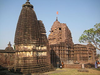
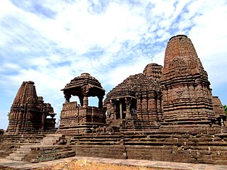
Markanda Mahadev Temple Complex is situated at the banks of the Wainganga River near Chamorshi town in the Gadchiroli District of Maharashtra. This 8th Century Temple Complex is called Mini Khajuraho. The nearest village is Marakand Deo.
