
Yellandu is a town in Bhadradri Kothagudem district of the Indian state of Telangana. It is located in Yellandu mandal of Kothagudem revenue division.

Bhadrachalam is a census town in the Indian state of Telangana, Bhadradri Kothagudem district. It is an important Hindu pilgrimage town with the Bhadrachalam Temple of Lord Rama, situated on the banks of Godavari river. It is located 312 kilometres (194 mi) from east of state capital, Hyderabad,115 kilometres (71 mi) from Khammam,192 kilometres (119 mi) from Vijayawada,177 kilometres (110 mi) from Suryapet, 180 kilometres (112 mi) from Warangal, 220 kilometres (137 mi), from the Andhra Pradesh State Capital Amaravathi, 350 kilometres (217 mi) from Visakhapatnam.
Khammam district is a district in the eastern region of the Indian state of Telangana. The city of Khammam is the district headquarters. The district shares boundaries with Suryapet, Mahabubabad, Bhadradri districts and with Andhra pradesh state.

Manuguru is a census town and mandal in Bhadradri Kothagudem district in the Indian state of Telangana. It comes under Mahaboobabad parliamentary constituency and Pinapaka Assembly constituency. Manuguru is an urban area, situated on the banks of Godavari River. The town is famous for Singareni coal mines. The singareni had provided many employment opportunities. Since there is a availability of coal the TS government has taken an action to construct a power plant(BTPS) in the coal city MANUGURU Pin code of Manuguru is 507117.
Chunchupalle is a census town in Bhadradri Kothagudem district of the Indian state of Telangana. It is located in Chunchupalli mandal of Kothagudem revenue division.
Palwancha is a town in Bhadradri district of the Indian state of Telangana. It is located in Palwancha mandal of Kothagudem revenue division.
Cherla is a mandal in Bhadradri Kothagudem district. It is located on the banks of River Godavari. Prior to 30 November 1959, it was a part of Bhadrachalam constituency in Bhadradri Kothagudem district
Burgampahad is the headquarters of Burgampahad mandal in Bhadradri Kothagudem district of the Indian state of Telangana.
Gundala is a mandal of Bhadradri Kothagudem District of Telangana state in India. It is located at and is near the town of Kothagudem. The headquarters of the sub-division are in the village of Gundala. The sub-division has 17 villages under its administration. Markode, Muthapuram and Lingagudem are the other populated regions in the mandal.
Dammapeta is a mandal in Bhadradri Kothagudem district, Telangana.
Pinapaka is a Mandal in Bhadradri Kothagudem district, Telangana.
Aswaraopeta is a mandal in Bhadradri Kothagudem district, Telangana.
Aswapuram or Ashwapuram is a Mandal in Bhadradri Kothagudem district, Telangana State, India.
Julurpad or Julurpadu is a mandal in Bhadradri Kothagudem district, Telangana, India.
Chandrugonda is a village in Chandrugonda mandal in Bhadradri Kothagudem district of Telangana, India.
Kothagudem Assembly constituency is a constituency of Telangana Legislative Assembly, India. It is one of constituencies in Bhadadri Kothadugem District. It includes the towns of Kothagudem and Palwancha and part of Khammam Lok Sabha constituency.

Gannavaram mandal is one of the 50 mandals in Krishna district of the Indian state of Andhra Pradesh. It is under the administration of Nuzvid revenue division and the headquarters are located at Gannavaram. The mandal is bounded by Agiripalle, Bapulapadu, Unguturu, Vijayawada (rural) and Kankipadu mandals. The mandal is also a part of the Andhra Pradesh Capital Region under the jurisdiction of APCRDA.
Bhadradri Kothagudem district is a district in the eastern region of the Indian state of Telangana. The town of Kothagudem is the district headquarters..In terms of area, Bhadradri Kothagudem is the largest district with an area of 7,483 km2 in the state.The district share boundaries with Khammam, Mahabubabad and Mulugu and withe state boundary of Chhattisgarh and Andhra Pradesh.
Kothagudem Airport is a proposed greenfield airport at Kothagudem in Bhadradri Kothagudem District of Telangana, India. The Government of Telangana has identified 1,600 acres of land at Punukuduchelka village in Kothagudem mandal for the purpose.

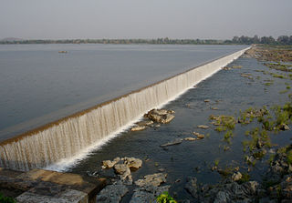
Sitamma Sagar Barrage is a proposed barrage across Godavari River with run-of-river hydroelectric power project at Dummugudem village, Bhadradri Kothagudem district in Telangana. The project is proposed at about 200 meters downstream of the existing Dummugudem anicut built about 150 years ago.

