Mulberry Street Bridge

Last updated
Mulberry Street Bridge

Mulberry street bridge 1913.jpg

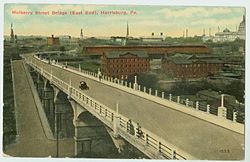
Postcard of the Mulberry Street Bridge as seen from Allison Hill in 1913
Coordinates 40°15′40″N76°52′30″W / 40.2612°N 76.875°W / 40.2612; -76.875 Coordinates: 40°15′40″N76°52′30″W / 40.2612°N 76.875°W / 40.2612; -76.875
Carries Motor vehicles and pedestrians
Crosses Cameron Street, Paxton Creek
Locale Harrisburg, Pennsylvania
Characteristics
Total length 178 m (584 ft)
Width 9.27 m (30.4 ft)
History
Opened 1907-09
rehabilitated 1957

The Mulberry Street Bridge is a concrete arch bridge that spans Cameron Street and Paxton Creek in Harrisburg, Pennsylvania. The bridge is the second constructed at the current site to connect the Allison Hill neighborhood of East Harrisburg to Downtown. It replaced an iron and fire-prone, wood-decked structure erected in 1891, which was heralded as a unifier of a “Greater Harrisburg.” [1] The concrete replacement bridge constructed in 1909, was a marvel at the time, and is eligible to be listed on the National Register of Historic Places. [2]

Bridge structure built to span physical obstacles

A bridge is a structure built to span a physical obstacle, such as a body of water, valley, or road, without closing the way underneath. It is constructed for the purpose of providing passage over the obstacle, usually something that can be detrimental to cross otherwise. There are many different designs that each serve a particular purpose and apply to different situations. Designs of bridges vary depending on the function of the bridge, the nature of the terrain where the bridge is constructed and anchored, the material used to make it, and the funds available to build it.

Paxton Creek tributary of the Susquehanna River in Pennsylvania, United States

Paxton Creek is a 13.9-mile-long (22.4 km) tributary of the Susquehanna River in Dauphin County, Pennsylvania in the United States.

Harrisburg, Pennsylvania Capital of Pennsylvania

Harrisburg is the capital city of the Commonwealth of Pennsylvania in the United States, and the county seat of Dauphin County. With a population of 49,192, it is the 15th largest city in the Commonwealth. It lies on the east bank of the Susquehanna River, 107 miles (172 km) west of Philadelphia. Harrisburg is the anchor of the Susquehanna Valley metropolitan area, which had a 2018 estimated population of 574,659, making it the fourth most populous in Pennsylvania and 96th most populous in the United States.

Related Research Articles

Wormleysburg, Pennsylvania Borough in Pennsylvania, United States

Wormleysburg is a borough in Cumberland County, Pennsylvania, United States. The population was 3,070 at the 2010 census. It is part of the Harrisburg–Carlisle Metropolitan Statistical Area.

Harrisburg University of Science and Technology

Harrisburg University of Science & Technology, commonly referred to as Harrisburg University (HU), is a private STEM-focused university in Harrisburg, Pennsylvania with satellite campuses in Philadelphia. Founded in 2001 Harrisburg, Pennsylvania as Harrisburg Polytechnic Institute, it offers STEM-focused degree and certificate programs.

City Island (Pennsylvania) Neighborhood of Harrisburg in Dauphin County, Pennsylvania, United States

City Island is a mile-long island in the Susquehanna River between Harrisburg and Wormleysburg, Pennsylvania in the United States. It is used mainly for leisure and sports activities. Its previous names have included Turkey Island, Maclay's Island, Forster's Island and Hargast Island.

Downtown Newark central business district in United States

Downtown Newark is the Central Business District of Newark in Essex County, New Jersey, United States.

Interstate 76 (I-76) is an Interstate Highway in the United States, running about 434 miles (700 km) from an interchange with I-71 west of Akron, Ohio, east to I-295 in Bellmawr, New Jersey.

The South Mountain Railroad was an American railroad which operated in Pennsylvania.

Downtown Harrisburg, Pennsylvania Neighborhood in Harrisburg in Dauphin County, Pennsylvania, United States

Downtown Harrisburg, is the central core business and government center which surrounds the focal point of Market Square, and serves as the regional center for the greater metropolitan area of Harrisburg, Pennsylvania, United States.

Allison Hill is a neighborhood in Harrisburg, Pennsylvania, in the United States. It is located directly east of downtown Harrisburg on a bluff overlooking the older original borough along the Susquehanna River. The Hill comprises many sub-neighborhoods with nicknames such as "The Ville" and the "Third Ward".

Conodoguinet Creek creek in Pennsylvania, United States

Conodoguinet Creek is a 104-mile-long (167 km) tributary of the Susquehanna River in South central Pennsylvania in the United States. The name is Native American, and means "A Long Way with Many Bends".

Pennsylvania Route 230 highway in Pennsylvania

Pennsylvania Route 230 is a 28.4-mile (45.7 km) long state route in central Pennsylvania. Its western terminus is at an intersection with U.S. Route 22 in Harrisburg. Its eastern terminus is at an interchange with PA 283 near Salunga. The route passes through Dauphin and Lancaster counties and serves as a surface road parallel to the PA 283 freeway that connects the cities of Harrisburg and Lancaster. Along the way, PA 230 passes through Middletown, Elizabethtown, and Mount Joy. The route intersects the Airport Connector near the Harrisburg International Airport, PA 441 and PA 341 in the Middletown area, PA 241 and PA 743 in Elizabethtown, and PA 772 in Mount Joy.

Strawberry Square is a mixed-use retail and commercial complex located in downtown Harrisburg, Pennsylvania. It is owned and managed by the Harristown Development Corporation (HDC), a non-profit organization.

WKBO is the callsign of an AM radio station licensed to serve Harrisburg, Pennsylvania. The station is owned by One Heart Ministries, Inc. and broadcasts a Christian contemporary format. Studios are located at Stage and Studio Cafe in Mechanicsburg, Pennsylvania and the station's tower is located at the Harrisburg Water plant.

U.S. Route 11 in Pennsylvania highway in Pennsylvania

U.S. Route 11 roughly parallels Interstate 81 in the U.S. state of Pennsylvania. It serves Harrisburg and Scranton. Between those two cities, US 11 follows the Susquehanna River, while I-81 follows a shorter route over the mountains.

Episcopal Diocese of Central Pennsylvania

The Episcopal Diocese of Central Pennsylvania is one of the dioceses of the Episcopal Church in the United States of America. It was founded in 1905 as the Diocese of Harrisburg, separating from the original Diocese of Central Pennsylvania now known as the Episcopal Diocese of Bethlehem. The seat of the bishop and home of the diocesan offices is St. Stephen's Episcopal Cathedral at 221 North Front Street in Downtown Harrisburg, Pennsylvania.

U.S. Route 11 (US 11) in the U.S. state of Tennessee travels from the Georgia state line in Chattanooga to Knoxville, where it then splits into US 11E and US 11W. These two highways then travel to the Virginia state line near Kingsport and Bristol. During its length, it shares concurrencies with SR 2 and SR 38.

Strasburg Road

Strasburg Road was an early road in Pennsylvania connecting Philadelphia to Strasburg in Lancaster County. The route was surveyed by John Sellers and others in 1772-3 under the colonial administration of Governor Richard Penn and completed under the new administration of the independent state of Pennsylvania. The route started at the "second ferry" on the Schuylkill River, today's Market Street in Philadelphia, and went through West Chester, East Fallowfield Township, and Gap, before ending in Strasburg. Earlier roads travelled much the same route, including a Native American path in use as early as 1620.

Italian Lake Park is a public park located at 3rd and Division Streets in the Uptown neighborhood of Harrisburg, Pennsylvania.

Market Square, Harrisburg, Pennsylvania Neighborhood of Harrisburg in Dauphin County, Pennsylvania, United States

Harrisburg's Market Square is located in Downtown Harrisburg at the intersection of 2nd and Market Streets. The square was created in 1785. Since then, it has traditionally been the heart of the city, and since the 1980s has undergone a revival with several new commercial, residential and retail spaces either planned or built. It is one block from Riverfront Park and the Market Street Bridge, which crosses over the Susquehanna River.

San Jacinto Street Bridge over Buffalo Bayou

The San Jacinto Street Bridge is a viaduct which crosses Buffalo Bayou in Houston, Texas. The structure is listed on the National Register of Historic Places (NRHP). This bridge was built in 1914 to replace an iron pivot bridge of 1883 origin, and rehabilitated in 1997. It is a transportation conduit connecting downtown and the historical Fifth Ward.

References

  1. City of Harrisburg (2004). "Visitors Guide to Downtown Harrisburg". harrisburgpa.gov/. Archived from the original on 2007-03-14. Retrieved 2006-12-23.
  2. Baughn, James (2006). "Mulberry Street Ramp Bridge". Historic Bridges of the United States. Retrieved 2006-12-23.

Coordinates: 40°15′40″N76°52′30″W / 40.2612°N 76.8750°W / 40.2612; -76.8750

Geographic coordinate system Coordinate system

A geographic coordinate system is a coordinate system that enables every location on Earth to be specified by a set of numbers, letters or symbols. The coordinates are often chosen such that one of the numbers represents a vertical position and two or three of the numbers represent a horizontal position; alternatively, a geographic position may be expressed in a combined three-dimensional Cartesian vector. A common choice of coordinates is latitude, longitude and elevation. To specify a location on a plane requires a map projection.