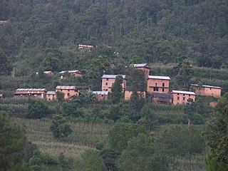
Okhaldhunga is the headquarters of the Okhaldhunga District in the Sagarmatha Zone of Nepal. At the time of the 1991 Nepal census it had a population of 3761 living in 790 individual households.

Kavrepalanchok District also known as Kavre is one of the 77 districts of Nepal. The district, with Dhulikhel as its district headquarters, covers an area of 1,396 km2 (539 sq mi). It is a part of Bagmati Province and has a population of 364,039.

Khotang District is one of 14 districts of Koshi Province of eastern Nepal. The district, with Diktel as its district headquarters, covers an area of 1,591 km2 (614 sq mi) and has a population (2021) of 206,312. The district is bordered by Bhojpur District in the east, Udayapur District in the south, Okhaldhunga District in the west and Solukhumbu District in the North. In this district there are two municipalities and eight rural/urban municipalities.

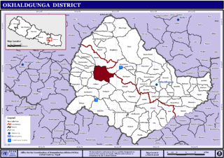
Okhaldhunga District is one of 14 districts of Koshi Province in eastern Nepal. The district, with the municipality of Okhaldhunga as its district headquarters, covers an area of 1,074.5 km2 (414.9 sq mi) and had a population of 156,702 in 2001 and 147,984 in 2011.

Solukhumbu District (Nepali: सोलुखुम्बु जिल्ला, Sherpa: ཤར་ཁུམ་བུ་རྫོང་།, Wylie: shar khum bu dzong) is one of 14 districts of Koshi Province of eastern Nepal. As the name suggests, it consists of the sub-regions Solu and Khumbu. The closest post office to Solukhumbu with a postal code assigned to it is the Sindhuli D.P.O., which has the postal code 56000.
Saping is a sparsely populated village in Kabhrepalanchok district, about 60 kilometres east of Kathmandu, Nepal. As of 2011 census, Saping village has 786 households with 3,246 individuals, 1,472 males and 1,774 females, and under the "new" federal structure, formed by a new constitution, adopted on 20 September 2015, Saping is now a part of Bhumlu Gaupalika and is organized as Ward Number 1.
Balakhu is a village development committee in Okhaldhunga District in the Sagarmatha Zone of mid-eastern Nepal. Balakhu Village is located on the bank of Sunkoshi river at the south western part of Okhaldhunga District.At the time of the 1991 Nepal census it had a population of 3703 living in 677 individual households. Simalchaur
Bhadaure is a village development committee in Okhaldhunga District in the Sagarmatha Zone of mid-eastern Nepal. At the time of the 1991 Nepal census it had a population of 3030.
Bilandu is a village development committee in Okhaldhunga District in the Sagarmatha Zone of mid-eastern Nepal. At the time of the 1991 Nepal census it had a population of 2279 living in 431 individual households. On December 15, 2010 a plane crashed in the forest of Bilandu, near the village of Shreechaur in the adjacent village development committee.
Chyanam is a village development committee in Okhaldhunga District in the Sagarmatha Zone of mid-eastern Nepal. At the time of the 1991 Nepal census it had a population of 3000 living in 585 individual households.
Katunje is a village development committee in Okhaldhunga District in the Sagarmatha Zone of mid-eastern Nepal. At the time of the 1991 Nepal census, it had a population of 4027 living in 824 individual households.
Khiji Phalate is a part of Khiji Chandeshwari it has village development committee in Okhaldhunga District in the Sagarmatha Zone of mid-eastern Nepal. At the time of the 1991 Nepal census it had a population of 2944 living in 459 individual households.
Moli is a village development committee in Okhaldhunga District in the Sagarmatha Zone of mid-eastern Nepal. At the time of the 1991 Nepal census it had a population of 3447 living in 597 individual households.
Raniban, Sagarmatha is a village development committee in Okhaldhunga District in the Sagarmatha Zone of mid-eastern Nepal. At the time of the 1991 Nepal census it had a population of 1874 living in 372 individual households.
Serna is a village development committee in Okhaldhunga District in the Sagarmatha Zone of mid-eastern Nepal. At the time of the 1991 Nepal census it had a population of 1790.
Taluwa is a village development committee in Okhaldhunga District in the Sagarmatha Zone of mid-eastern Nepal. At the time of the 1991 Nepal census, it had a population of 2067 living in 371 individual households.
Vadaure is a village development committee in Okhaldhunga District in the Province No. 1 of mid-eastern Nepal. At the time of the 1991 Nepal census it had a population of 2498 living in 451 individual households.
Sanghutar is a village development committee in Ramechhap District in the Janakpur Zone of north-eastern Nepal. At the time of the 1991 Nepal census it had a population of 2,177 people living in 394 individual households. The VDC has a small market called Sanghutar Bazaar, situated in the bank of the Likhu River and bordering Okhaldhunga District. The bazaar is flat land near to the bridge ; therefore, its name is Sanghutar. It is a main commercial center of many neighboring villages of Ramechhap and Okhaldhunga District with a higher secondary school called Himaganga.
Srichaur is a village development committee in Okhaldhunga District in the Sagarmatha Zone of mid-eastern Nepal. At the time of the 1991 Nepal census it had a population of 2388 living in 437 individual households. On December 15, 2010 a plane crashed in the forest of Bilandu, in the southwestern part of Shreechaur VDC.
Sunkoshi Rural Municipality in Okhaldhunga District was formed in March 2017, by merging 5 former VDCs of Katunje, Chyanam, Mulkharka, Sisneri and Balakhu. The center of this rural municipality is located at Mulkharka.

