
Kvinnherad is a municipality in Hordaland county, Norway. It is located in the traditional district of Sunnhordland, along the Hardangerfjorden. The municipality is the 5th in size in Hordaland county.

Jondal is a municipality in Hordaland county, Norway. It is located on the Folgefonna peninsula in the Hardanger district, on the eastern shore of the Hardangerfjorden. The administrative centre of the municipality is the village of Jondal. Other villages in Jondal include Herand, Kysnesstranda, and Torsnes.

The Hardangerfjord is the fourth longest fjord in the world, and the second longest fjord in Norway. It is located in Hordaland county in the Hardanger region. The fjord stretches 179 kilometres (111 mi) from the Atlantic Ocean into the mountainous interior of Norway along the Hardangervidda plateau. The innermost point of the fjord reaches the town of Odda.

Øystese is a village in the municipality of Kvam in Hordaland county, Norway. It is located along the Hardangerfjord about 7 kilometres (4.3 mi) east of the municipal centre of Norheimsund. Norwegian County Road 7 passes through the village. The 1.89-square-kilometre (470-acre) village has a population (2012) of 1,881; giving the village a population density of 995 inhabitants per square kilometre (2,580/sq mi).
Bjølsegrøvvatnet is a lake in the municipality of Kvam in Hordaland county, Norway. The 5.82-square-kilometre (2.25 sq mi) lake lies at an altitude of 880 metres (2,890 ft) above sea level in the mountains east of the Fyksesund fjord and northwest of the village of Ålvik. It has a dam on the southeastern tip of the lake to regulate the amount of water in it. The lake is used as a reservoir for the nearby Bjølvo hydroelectric power station.
Steine is a village in the municipality of Kvam in Hordaland county, Norway. It is located in the Steinsdalen valley which runs from the Kvamskogen area to the outskirts of the large village of Norheimsund. Norwegian County Road 7 runs through Steine. The Steinsdalsfossen waterfall is a notable tourist attraction in the village.
Kysnesstranda is a village in the Jondal municipality, Hordaland county, Norway. The village lies along the southern shore of the Hardangerfjorden. The village lies about 15 kilometres (9.3 mi) south of the municipal centre of Jondal.

Holmavatnet or Holmevatnet is a lake in the municipality of Kvam in Hordaland county, Norway. It is located on the north side of Kvamskogen, about 12 kilometres (7.5 mi) northwest of the municipal centre of Norheimsund. The western end of the lake is dammed for purposes of hydroelectric power generation.

Fjelberg is a former municipality in Hordaland county, Norway. The municipality existed from 1838 until 1965 when it was dissolved. In 1965, the municipality covered 79.8 square kilometres (30.8 sq mi), mostly islands and a small area on the mainland. It encompassed part of the present day municipalities of Kvinnherad and Vindafjord, primarily the islands of Fjelbergøya, Borgundøya, and Halsnøya, as well as some surrounding areas on the mainland. The administrative centre of the municipality was the small village located on the island of Fjelbergøya where Fjelberg Church is located.
Bru or Ploganes is a village in the municipality of Kvam in Hordaland county, Norway. It's located in the Strandebarm area, on the northern shore of the Hardangerfjorden. It is located about 6 kilometres (3.7 mi) north of the village of Omastranda and about 10 kilometres (6.2 mi) northwest from the village of Kysnesstranda in Jondal Municipality.

Hatlestrand is a village in Kvinnherad municipality in Hordaland county, Norway. The village is located along the Hardangerfjorden, northeast of the villages of Husa and Ølve. The village has a ferry port called Gjermundshamn, which has regular ferry connections to the island of Varaldsøy and to Årsnes on the opposite side of the fjord. Hatlestrand Church is located in the village.
Bergsdalen is a river valley in Vaksdal municipality, Hordaland county, Norway. The 16-kilometre (9.9 mi) long valley begins at the lake Hamlagrøvatnet on the border of the municipalities of Vaksdal, Voss, and Kvam. The valley then runs to the northwest along the river Bergsdalselvi all the way to the village of Dale where the valley ends. This valley was historically part of the main route between the city of Bergen and Voss, until the European route E16 highway was built to the north of the valley.
Varaldsøy is a former municipality in Hordaland county, Norway. The 83-square-kilometre (32 sq mi) municipality encompassed the whole island of Varaldsøy and a 2-to-3-kilometre wide strip of the mainland northwest and west of the island. The administrative centre of the municipality was the village area of Varaldsøy on the southern part of the island, where Varaldsøy Church is located.
Strandebarm Church is a parish church in Kvam municipality in Hordaland county, Norway. It is located in the village of Bru. The church is part of the Strandebarm parish in the Hardanger og Voss deanery in the Diocese of Bjørgvin. Historically, this was the main church for the old Strandebarm municipality.
Tørvikbygd is a village in Kvam municipality Hardanger, Hordaland, Norway. The village is located on the west side of Hardanger Fjord, around 13 km south of the community center Norheimsund.

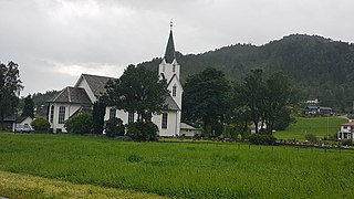
Varaldsøy Church is a parish church in Kvinnherad municipality in Hordaland county, Norway. It is located on the island of Varaldsøy. The church is part of the Varaldsøy parish in the Sunnhordland deanery in the Diocese of Bjørgvin. The white, wooden church was built in 1885 by the architects Conrad Fredrik von der Lippe and Hans Heinrich Jess. The church, which seats about 390 people, was consecrated on 25 November 1885 by the Bishop Waldemar Hvoslef.
County Road 550 is an 81.96-kilometer (50.93 mi) road in Norway. The road runs from Jondal in the municipality of Jondal to Odda in the municipality of Odda.


