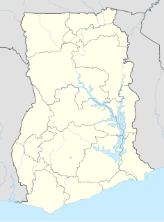
Ghana is a West African country in Africa, along the Gulf of Guinea, just a few degrees north of the equator.

UNESCO Biosphere Reserves are environment-protected scientific-research institutions of international status that are created with the intent for conservation in a natural state the most typical natural complexes of biosphere, conducting background ecological monitoring, studying of the surrounding natural environment, its changes under the activity of anthropogenic factors.

The Towra Point Nature Reserve is a protected nature reserve that is located in Sutherland Shire, southern Sydney, New South Wales, in eastern Australia. The 603-hectare (1,490-acre) reserve is situated on the southern shores of Botany Bay at Kurnell, within the Sutherland Shire. The reserve is protected under the Ramsar Convention as a wetland of international importance as an important breeding ground for many vulnerable, protected, or endangered species. The Towra Point Aquatic Nature Reserve is located in the surrounding waterways.

The Cape Floristic Region is a floristic region located near the southern tip of South Africa. It is the only floristic region of the Cape Floristic Kingdom, and includes only one floristic province, known as the Cape Floristic Province.

The wildlife of Liberia consists of the flora and fauna of the Republic of Liberia. This West African nation has a long Atlantic coastline and a range of habitat types, with a corresponding diversity of plants and animals. Liberia is considered a biodiversity hotspot and has more intact forests characteristic of the Upper Guinea Massif than do neighbouring countries. There are 2000 species of vascular plants, approximately 140 species of mammals, and over 600 species of birds.

The wildlife of Togo is composed of the flora and fauna of Togo, a country in West Africa. Despite its small size the country has a diversity of habitats; there are only remnants of the once more extensive rain forests in the south, there is Sudanian Savanna in the north-western part of the country and larger areas of Guinean forest-savanna mosaic in the centre and northeast. The climate is tropical with distinct wet and dry seasons. There are estimated to be over 3000 species of vascular plant in the country, and 196 species of mammal and 676 species of bird have been recorded there.

Bundala National Park is an internationally important wintering ground for migratory water birds in Sri Lanka. Bundala harbors 197 species of birds, the highlight being the greater flamingo, which migrate in large flocks. Bundala was designated a wildlife sanctuary in 1969 and redesignated to a national park on 4 January 1993. In 1991 Bundala became the first wetland to be declared as a Ramsar site in Sri Lanka. In 2005 the national park was designated as a biosphere reserve by UNESCO, the fourth biosphere reserve in Sri Lanka. The national park is situated 245 kilometres (152 mi) southeast of Colombo.

The Central African mangroves ecoregion consists of the largest area of mangrove swamp in Africa, located on the coasts of West Africa, mainly in Nigeria.

The Ord River floodplain is the floodplain of the lower Ord River in the Shire of Wyndham-East Kimberley, in the Kimberley region of northern Western Australia. It lies within the Victoria Bonaparte IBRA bioregion and contains river, seasonal creek, tidal mudflat and floodplain wetlands, with extensive stands of mangroves, that support saltwater crocodiles and many waterbirds. It is recognised as an internationally important wetland area, with 1,384 km2 of it designated on 7 June 1990 as Ramsar Site 477 under the Ramsar Convention on Wetlands.

Keta Lagoon, also called Anlo-Keta lagoon, is the largest of the over 90 lagoons that cover the 550 km stretch of the coastline of Ghana. This lagoon is 126.13 km in length. It is located in the eastern coast of Ghana and separated from the Gulf of Guinea by a narrow strip of sandbar. This open salty water is surrounded by flood plains and mangrove swamps. Together they form the Keta Lagoon Ramsar site which covers 1200 km2
The Songor Lagoon is located at 05°45'N 000°30'E on the eastern coast of Ghana, West Africa. The site covers an area of 28,740 hectares, and it is located just outside the major town of Ada and to the west of the Volta River estuary. It was designated as Ramsar wetland site of international importance number 566 on June 22, 1988. In 2011, UNESCO approved the Songor Biosphere Reserve as part of the World Network of Biosphere Reserves. Among several other important functions, it acts as habitat and/or breeding ground for several notable species.

The Hunter Estuary Wetlands comprise a group of associated wetlands at and near the mouth of the Hunter River in the city of Newcastle, New South Wales, Australia. Some 30 km2 of the wetlands has been recognised as being of international importance by designation under the Ramsar Convention. It was listed on 21 February 1984 as Ramsar site 287. A larger area of the wetlands has been identified by BirdLife International as an Important Bird Area (IBA). The wetlands are recognised as the most important area in New South Wales for waders, or shorebirds.

The Little Llangothlin Nature Reserve is a protected wetland nature reserve that is located on the Northern Tablelands in the New England region of New South Wales, in eastern Australia. The 257-hectare (640-acre) reserve is situated approximately 10 kilometres (6.2 mi) north-east of the rural locality of Llangothlin, and some 20 kilometres (12 mi) north-east of Guyra.

The Sakumo Ramsar Site also known as the Sakumo Lagoon is a wetland of international importance. It covers an area of 1,400 hectares and is situated along the coastal road between Accra and Tema in the Greater Accra Region of Ghana. It is about 3 km (1.9 mi) west of Tema. Activities ongoing within the Ramsar Site include farming, fishing, recreation, urban and industrial development.

Biodiversity in Suriname is high, mostly because of the variety of habitats and the temperature. The average annual temperature in the coastal area is between 26° and 28° Celsius. Suriname can be divided into four major ecological zones, namely from north to south;
- The young coastal plain
- The old coastal plain
- The Savannah or Zanderij belt
- The interior residual uplands.

Younger Lagoon Reserve is a 72-acre (28-hectare) University of California Natural Reserve System reserve on the northern shore of Monterey Bay in Santa Cruz County, California. The site is owned by the University of California and managed for teaching and research. It is adjacent to Long Marine Laboratory.

Ría Lagartos Biosphere Reserve is a UNESCO Biosphere Reserve in the state of Yucatán, Mexico. The reserve is located at the eastern end of the coastal strip of the Yucatán Peninsula, with the Gulf of Mexico at its northern limit. The area encompasses coastal areas of the Gulf of Mexico and includes important wetlands designated under the Ramsar Wetlands Convention. The site presents a rich diversity of landscapes and ecosystems, such as mangroves, small estuaries, medium semi-evergreen forest, low deciduous forest, coastal dune vegetation, coastal lagoons, marshes (petenes) and savanna represented by tular vegetation, grasslands and reed beds that are the main nesting sites for marshland and sea birds.

The Red River Delta Biosphere Reserve is a UNESCO biosphere reserve in the coastal region of northern Vietnam. Mangroves and intertidal habitats of the Red River Delta form wetlands of high biodiversity especially in the Xuan Thuy and Tien Hai districts. These wetlands are of global importance as migratory sites for several bird species.

The Araya and Paria xeric scrub (NT1301) is an ecoregion in Venezuela that stretches along the Caribbean coast to the west of Trinidad, and that includes Margarita Island and some smaller islands. The ecoregion includes dune herbs, dry thorn scrubs and deciduous forests. The mountains on Margarita Island hold montane forests similar to those in the mainland coastal range. The beaches are used for breeding by sea turtles. Some endemic bird species are threatened with extinction by illegal capture for the pet trade. Deforestation and over-grazing by goats are also problems.


