Related Research Articles

Veracruz, formally Veracruz de Ignacio de la Llave, officially the Estado Libre y Soberano de Veracruz de Ignacio de la Llave, is one of the 31 states which, along with Mexico City, comprise the 32 Federal Entities of Mexico. Located in eastern Mexico, Veracruz is bordered by seven states, which are Tamaulipas, San Luis Potosí, Hidalgo, Puebla, Oaxaca, Chiapas, and Tabasco. Veracruz is divided into 212 municipalities, and its capital city is Xalapa-Enríquez.

The Totonac are an indigenous people of Mexico who reside in the states of Veracruz, Puebla, and Hidalgo. They are one of the possible builders of the pre-Columbian city of El Tajín, and further maintained quarters in Teotihuacán. Until the mid-19th century they were the world's main producers of vanilla.
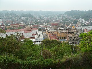
Papantla is a city and municipality located in the north of the Mexican state of Veracruz, in the Sierra Papanteca range and on the Gulf of Mexico. The city was founded in the 13th century by the Totonacs and has dominated the Totonacapan region of the state since then. The region is famed for vanilla, which occurs naturally in this region, the Danza de los Voladores and the El Tajín archeological site, which was named a World Heritage Site. Papantla still has strong communities of Totonacs who maintain the culture and language. The city contains a number of large scale murals and sculptures done by native artist Teodoro Cano García, which honor the Totonac culture. The name Papantla is from Nahuatl and most often interpreted to mean "place of the papanes". This meaning is reflected in the municipality's coat of arms.

Cempoala or Zempoala is an important Mesoamerican archaeological site located in the municipality of Úrsulo Galván in the Mexican state of Veracruz. The site was inhabited mainly by Totonacs, Chinantecas and Zapotecs. It was one of the most important Totonac settlements during the postclassical Mesoamerican period and the capital of the kingdom of Totonacapan. It is located one kilometer from the shore of the Actopan River and six kilometres from the coast.

Totonacapan refers to the historical extension where the Totonac people of Mexico dominated, as well as to a region in the modern states of Veracruz and Puebla. The historical territory was much larger than the currently named region, extending from the Cazones River in the north to the Papaloapan River in the south and then west from the Gulf of Mexico into what is now the Sierra Norte de Puebla region and into parts of Hidalgo. When the Spanish arrived, the Totonac ethnicity dominated this large region, although they themselves were dominated by the Aztec Empire. For this reason, they allied with Hernán Cortés against Tenochtitlán. However, over the colonial period, the Totonac population and territory shrank, especially after 1750 when mestizos began infiltrating Totonacapan, taking political and economic power. This continued into the 19th and 20th centuries, prompting the division of most of historical Totonacpan between the states of Puebla and Veracruz. Today, the term refers only to a region in the north of Veracruz where Totonac culture is still important. This region is home to the El Tajín and Cempoala archeological sites as well as Papantla, which is noted for its performance of the Danza de los Voladores.
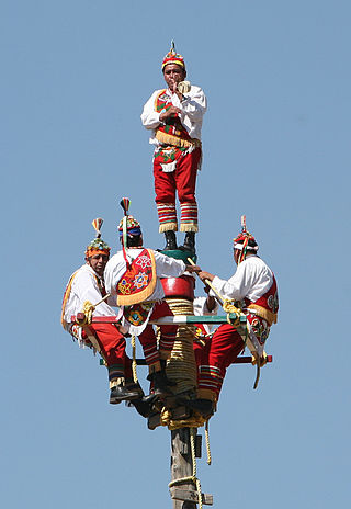
The Danza de los Voladores, or Palo Volador, is an ancient Mesoamerican ceremony/ritual still performed today, albeit in modified form, in isolated pockets in Mexico. It is believed to have originated with the Nahua, Huastec and Otomi peoples in central Mexico, and then spread throughout most of Mesoamerica. The ritual consists of dance and the climbing of a 30-meter pole from which four of the five participants then launch themselves tied with ropes to descend to the ground. The fifth remains on top of the pole, dancing and playing a flute and drum. According to one myth, the ritual was created to ask the gods to end a severe drought. Although the ritual did not originate with the Totonac people, today it is strongly associated with them, especially those in and around Papantla in the Mexican state of Veracruz. The ceremony was named an Intangible cultural heritage by UNESCO in order to help the ritual survive and thrive in the modern world. The Aztecs believed that Danza de los Voladores was the symbol of their culture.

La Huasteca is a geographical and cultural region located partially along the Gulf of Mexico and including parts of the states of Tamaulipas, Veracruz, Puebla, Hidalgo, San Luis Potosí, Querétaro and Guanajuato. It is roughly defined as the area in which the Huastec people had influence when their civilization was at its height during the Mesoamerican period. Today, the Huastecs occupy only a fraction of this region with the Nahua people now the most numerous indigenous group. However, those who live in the region share a number of cultural traits such as a style of music and dance, along with religious festivals such as Xantolo.
Huasteca Nahuatl is a Nahuan language spoken by over a million people in the region of La Huasteca in Mexico, centered in the states of Hidalgo (Eastern) and San Luis Potosí (Western).
Cuyuxquihui is an archaeological site located in the Tecolutla valley of Veracruz, Mexico, in the region of the Totonac culture, about 22 kilometres (14 mi) southeast of El Tajín or 5 kilometres (3.1 mi) southeast of Paso de Correo.
Zacapoaxtla is a city and seat of the Zacapoaxtla Municipality, in the Mexican state of Puebla. The city has a population of 8,062 inhabitants, while the municipality has 49,242 inhabitants at the 2000 census.

The Sierra Norte de Puebla is a rugged mountainous region accounting for the northern third of the state of Puebla, Mexico. It is at the intersection of the Trans-Mexican Volcanic Belt and the Sierra Madre Oriental, between the Mexican Plateau and the Gulf of Mexico coast. From the Mesoamerican period to the 19th century, this area was part of a larger region called Totonacapan, and area dominated by the Totonac people, extending further east to the Gulf of Mexico. Political maneuvers to weaken the Totonacs led to the region being divided between the modern states of Puebla and Veracruz with the Puebla section given its current name. Until the 19th century, the area was almost exclusively indigenous, with the four main groups still found here today, Totonacs, Nahuas, Otomis and Tepehuas, but coffee cultivation brought in mestizos and some European immigrants who took over political and economic power. While highly marginalized socioeconomically, the area has been developed heavily since the mid 20th century, especially with the building of roadways linking it to the Mexico City area and the Gulf coast.

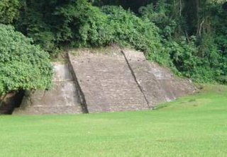
Huatusco is an archaeological site located in the Carrillo Puerto municipality, near the small, almost deserted town of Santiago Huatusco, on the northern bank of the Rio Atoyac in the Rancho El Fortin. The importance of the site due to the nearly undamaged pyramid from prehispanic times, the largest part of the actual temple is still standing, in the state of Veracruz, Mexico.
Mesa de Cacahuatenco is a Mesoamerican pre-Columbian archeological site, located in the municipality of Ixhuatlán de Madero in northern Veracruz, Mexico, south of the Vinasca River.

The Tecolutla River is a river in the state of Veracruz in Mexico, and the main drainage of the historical and cultural region of Totonacapan. It is principally fed by four rivers that rise in the Sierra Norte de Puebla: from north to south, they are the Necaxa, the Lajajalpan, the Tecuantepec and the Apulco. These rivers converge in the municipality of Espinal, Veracruz, and from here the Tecolutla flows about 100 kilometres (62 mi) east through the coastal plain and the municipalities of Papantla and Gutiérrez Zamora to its mouth at the town of Tecolutla on the Gulf of Mexico, On its south bank the Tecolutla receives the Joloapan River near Paso del Correo, and the Chichicatzapan River via the Ostiones estuary near its mouth.
Huehuetla is a rural municipality in Puebla, Mexico.

The Tepehuas are an indigenous people of Mexico whose name means in Nahuatl, "people of the mountain", although they refer to themselves without a term or name that encompasses a supposed ethnic group. They also use endoethnonyms that originate in Spanish-influenced Nahuatl:
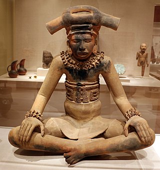
The Totonac culture or Totonec culture was a culture that existed among the indigenous Mesoamerican Totonac people who lived mainly in Veracruz and northern Puebla. Originally, they formed a confederation of cities, but, in later times, it seems that they were organized in three dominions: North, South and Serran. Its economy was agricultural and commercial. They had large urban centers such as: El Tajín (300–1200), which represents the height of the Totonac culture, Papantla (900–1519) and Cempoala (900–1519).

The Huasteca Alta region is one of the regions of the Mexican state of Veracruz. It is part of the broader Huasteca region that comprises parts of the states of Tamaulipas, Veracruz, Puebla, Hidalgo, San Luis Potosí, Querétaro and Guanajuato.
The Huasteca Baja region is one of the regions of the Mexican state of Veracruz. It is part of the broader Huasteca region that comprises parts of the states of Tamaulipas, Veracruz, Puebla, Hidalgo, San Luis Potosí, Querétaro and Guanajuato.

The geography of the State of Hidalgo refers to the physical geography and human geography of Hidalgo, a state in central Mexico.
References
- Valderrama Rouy, Pablo. 2005. In Sandstrom, Alan R., and Enrique Hugo García Valencia. 2005. Native peoples of the Gulf Coast of Mexico. Tucson: University of Arizona Press.