Huehuetla, Puebla

Last updated
Huehuetla
Huehuetla, Puebla, Pue..JPG
The town and municipal seat of Huehuetla
Escudo de Huehuetla.JPG
Mexico Puebla Huehuetla location map.svg
Location in Puebla
Mexico States blank map.svg
Red pog.svg
Huehuetla
Location in Mexico
Coordinates: 20°06′27″N97°37′24″W / 20.10750°N 97.62333°W / 20.10750; -97.62333 [1]
CountryFlag of Mexico.svg  Mexico
State Flag of Puebla.svg Puebla
Established1895
SeatHuehuetla
Government
[2]
  PresidentRuben Vázquez Cabrera
Area
[1]
  Total48 km2 (19 sq mi)
Elevation
[1] (of seat)
562 m (1,844 ft)
Population
 (2010 Census) [3]
  Total15,689
  Estimate 
(2015 Intercensal Survey) [4]
18,803
  Density330/km2 (850/sq mi)
  Seat
1,764
Time zone UTC-6 (Central)
  Summer (DST) UTC-5 (Central)
Postal code of seat
73470
Area code 233

Huehuetla (Nahuatl: "old place" [2] ) is a rural municipality in Puebla, Mexico. [1]

Contents

Geography

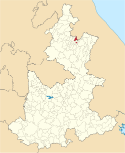
Huehuetla is located in northern Puebla on its border with Veracruz. The southern exclave of San Juan Ocelonacaxtla is separated from the rest of the municipality by Caxhuacan and Ixtepec. The main part of the municipality also borders Olintla and Hueytlalpan in the west and the Veracruzian municipalities of Coxquihui and Zozocolco de Hidalgo in the east. San Juan Ocelonacaxtla additionally borders the Pueblan municipalities of Tuzamapan de Galeana, Jonotla, Zoquiapan and Atlequizayan. [3] Huehuetla covers an area of 48 square kilometres (19 sq mi). [1]

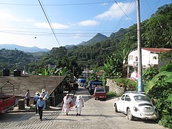
Situated in the Sierra Norte de Puebla, Huehuetla's topography is quite rugged, with hills topping 800 metres (2,600 ft) above sea level descending to river valleys less than 300 metres (980 ft) above sea level. The municipality is located in the Tecolutla River basin. The main river in the municipality is the Tehuancate, which flows through it from west to east. The Tehuancate drains into the Zempoala River, which also forms the southeastern boundary of the Ocelonacaxtla exclave. [2] Over half of the land in the municipality is used for agriculture, although the soils in the municipality are leptosols and poorly suited for agriculture. [5]

Huehuetla is located in a climatic transition zone between the temperate Sierra Norte and the hot Gulf of Mexico coast. Rain occurs throughout the year. [2] Average temperatures range between 18 and 24 degrees Celsius and average annual precipitation is between 2900 and 3600 millimetres. [5]

History

In Pre-Hispanic times, Huehuetla was inhabited by Nahua and Totonac peoples. Spanish settlement of the area began in 1550: property titles were first given to settlers in 1574, in which the area was named San Salvador Huehuetla. Previously part of the district of Zacatlán, Huehuetla was established as a free municipality in 1895. [2]

Administration

The municipal government comprises one councillor (Spanish: síndico) and eight trustees (regidores), six of whom are elected by relative majority and two by proportional representation, headed by a president. The current president of the municipality is Ruben Vázquez Cabrera. San Juan Ocelonacaxtla elects an auxiliary board (junta auxiliar) whose functions are subject to the municipal authorities. [2]

Demographics

In the 2010 Mexican Census, the municipality of Huehuetla recorded a population of 15,689 inhabitants living in 3361 households. [6] It recorded a population of 18,803 inhabitants in the 2015 Intercensal Survey. [4]

There are 14 localities in the municipality, [1] of which only the municipal seat, also called Huehuetla, is classified as urban. It recorded a population of 1764 inhabitants in the 2010 Census. [6] The Ozelonacaxtla exclave, located 12 kilometres (7.5 mi) south of the municipal seat, [2] recorded a population of 1326 inhabitants in the 2010 Census. [6]

Culture

Huehuetla is located in the cultural region of Totonacapan. [7] In the 2015 Intercensal Survey, 97.68% of people in the municipality identified themselves as indigenous. [4] In the 2010 Census, 12,904 people or 82% of the population in Huehuetla reported speaking an indigenous language, of which 12,187 spoke Totonac. [1] In the 2015 Intercensal Survey, 29.52% of the people reported speaking an indigenous language did not speak Spanish. [4] Sociolinguistic fieldwork done in Ozelonacaxtla indicates that Totonac language vitality in that community remains high. [8] The Independent Totonac Organization (Organización Independiente Totonaca, OIT) is an indigenous social movement founded in 1989 that has played an influential role in promoting the revitalization of Totonac culture and advancing the interests of the Totonac people in the area. [7] [9]

Economy

The main economic activity in Huehuetla is agriculture: [2] main crops include coffee and corn. [7] The gross domestic product of the municipality was unofficially estimated at 263.9 million Mexican pesos in 2010. [10]

Related Research Articles

Sierra Totonac is a native American language complex spoken in Puebla and Veracruz, Mexico. One of the Totonacan languages, it is also known as Highland Totonac. The language is best known through the work of the late Herman “Pedro” Aschmann who produced a small dictionary and several academic articles on the language.

<span class="mw-page-title-main">San José del Rincón</span> Municipality in Mexico, Mexico

San José del Rincón is a municipality in the State of Mexico. Its inhabitants are referred to as monteros.

<span class="mw-page-title-main">Tlaxco Municipality, Tlaxcala</span> Municipality in Tlaxcala, Mexico

Tlaxco is a municipality in the Mexican state of Tlaxcala in south-eastern Mexico.

Comapa is a municipality in the Mexican state of Veracruz, located about 40 kilometres (25 mi) south of the state capital Xalapa.

<span class="mw-page-title-main">Jilotepec, Veracruz</span> Municipality in Veracruz, Mexico

Jilotepec is a municipality in the Mexican state of Veracruz, located 11 kilometres (6.8 mi) north-northwest of the state capital Xalapa.

Las Minas is a municipality in the Mexican state of Veracruz, located 28 kilometres (17 mi) northeast of the state capital Xalapa.

<span class="mw-page-title-main">Los Reyes, Veracruz</span> Municipality in Veracruz, Mexico

Los Reyes is a municipality in the Mexican state of Veracruz, located about 100 kilometres (62 mi) south of the state capital Xalapa.

Naranjal is a municipality in the Mexican state of Veracruz, located 10 kilometres (6.2 mi) south of the city of Córdoba.

<span class="mw-page-title-main">Tepetzintla, Veracruz</span> Municipality in Veracruz, Mexico

Tepetzintla is a municipality in the Mexican state of Veracruz, located 207 kilometres (129 mi) northwest of the state capital of Xalapa and 119 kilometres (74 mi) south of the city of Tampico.

<span class="mw-page-title-main">Citlaltépetl, Veracruz</span> Municipality in Veracruz, Mexico

Citlaltépetl is a municipality in the Mexican state of Veracruz, located 223 kilometres (139 mi) northwest of the state capital of Xalapa and 99 kilometres (62 mi) south of the city of Tampico, Tamaulipas.

<span class="mw-page-title-main">Tomatlán, Veracruz</span> Municipality in Veracruz, Mexico

Tomatlán is a municipality in the Mexican state of Veracruz, located 58 kilometres (36 mi) south of the state capital of Xalapa.

<span class="mw-page-title-main">Xoxocotla, Veracruz</span> Municipality in Veracruz, Mexico

Xoxocotla is a municipality in the Mexican state of Veracruz, located 103 kilometres (64 mi) south of the state capital Xalapa.

<span class="mw-page-title-main">Zacualpan, Veracruz</span> Municipality in Veracruz, Mexico

Zacualpan is a municipality in the Mexican state of Veracruz, located 179 kilometres (111 mi) northwest of the state capital of Xalapa and 56 kilometres (35 mi) northeast of the city of Pachuca, Hidalgo.

Zaragoza is a municipality in the Mexican state of Veracruz, located 297 kilometres (185 mi) southeast of the state capital of Xalapa and 10 kilometres (6.2 mi) southwest of the city of Minatitlán.

<span class="mw-page-title-main">Churintzio</span> Municipality in Michoacán, Mexico

Churintzio is a municipality in the Mexican state of Michoacán, located 104 kilometres (65 mi) northwest of the state capital of Morelia.

<span class="mw-page-title-main">Cojumatlán de Régules</span> Municipality in Michoacán, Mexico

Cojumatlán de Régules is a municipality in the Mexican state of Michoacán, located 180 kilometres (110 mi) west of the state capital of Morelia.

Contepec is a municipality in the Mexican state of Michoacán, located 110 kilometres (68 mi) east of the state capital of Morelia.

<span class="mw-page-title-main">Nahuatzen</span> Municipality in Michoacán, Mexico

Nahuatzen is a municipality in the Mexican state of Michoacán, located approximately 75 kilometres (47 mi) west of the state capital of Morelia.

<span class="mw-page-title-main">Vista Hermosa, Michoacán</span> Municipality in Michoacán, Mexico

Vista Hermosa is a municipality in the Mexican state of Michoacán, located approximately 150 kilometres (93 mi) northwest of the state capital of Morelia.

<span class="mw-page-title-main">Miguel Auza Municipality</span> Municipality in Zacatecas, Mexico

Miguel Auza is a municipality in the Mexican state of Zacatecas, located approximately 190 kilometres (120 mi) northwest of the state capital of Zacatecas City.

References

  1. 1 2 3 4 5 6 7 "Sistema Nacional de Información Municipal" (in Spanish). SEGOB. 2010. Retrieved 16 November 2017.
  2. 1 2 3 4 5 6 7 8 "Huehuetla". Enciclopedia de los Municipios y Delegaciones de México (in Spanish). INAFED . Retrieved 16 November 2017.
  3. 1 2 "Huehuetla: Datos generales". Cédulas de información municipal (in Spanish). SEDESOL. 2013. Retrieved 16 November 2017.
  4. 1 2 3 4 "Panorama sociodemográfico de Puebla 2015" (PDF). INEGI. 2016. p. 168. ISBN   978-607-739-864-6 . Retrieved 16 November 2017.
  5. 1 2 "Compendio de Información Geográfica Municipal 2010: Huehuetla, Puebla". INEGI . Retrieved 16 November 2017.
  6. 1 2 3 "Resumen municipal: Municipio de Huehuetla". Catálogo de Localidades (in Spanish). SEDESOL . Retrieved 16 November 2017.
  7. 1 2 3 Hernández Aguilar, Luis Manuel (2010). "Si con el nombre de indios nos humillaron y explotaron, con el nombre de indios nos liberaremos": El proceso de configuración de un Sujeto Político Indígena, estudio de caso de la Organización Independiente Totonaca (OIT) (PDF) (MSSc thesis) (in Spanish). FLACSO . Retrieved 16 November 2017.
  8. "Other communities". Upper Necaxa Totonac Project. Retrieved 16 November 2017.
  9. "Totonac Cultural Revitalization". Ethnoscope. 29 April 1995. Retrieved 16 November 2017.
  10. González-Estrada, Adrián; Gallegos-Cedillo, Gilberto (2014). "The gross domestic product of municipalities of Mexico: II. Estates M-Z" (PDF). Revista Mexicana de Ciencias Agrícolas. 5 (8): 1405–1421. Retrieved 16 November 2017.