Huauchinango Municipality | |
|---|---|
 | |
 Seal | |
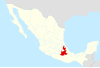
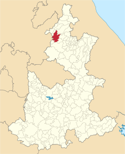 Location of the municipality in Puebla | |
| Country | |
| State | Puebla |
| Time zone | UTC-6 (Central Standard Time) |
Huauchinango is a municipality in the Mexican state of Puebla. [1] The municipal seat is at Huauchinango.
Huauchinango Municipality | |
|---|---|
| | |
| Seal | |
| Location of the municipality in Puebla | |
| Country | |
| State | Puebla |
| Time zone | UTC-6 (Central Standard Time) |
Huauchinango is a municipality in the Mexican state of Puebla. [1] The municipal seat is at Huauchinango.

Veracruz, formally Veracruz de Ignacio de la Llave, officially the Free and Sovereign State of Veracruz de Ignacio de la Llave, is one of the 31 states which, along with Mexico City, comprise the 32 Federal Entities of Mexico. Located in eastern Mexico, Veracruz is bordered by seven states, which are Tamaulipas, San Luis Potosí, Hidalgo, Puebla, Oaxaca, Chiapas, and Tabasco. Veracruz is divided into 212 municipalities, and its capital city is Xalapa-Enríquez.

The State of Mexico, officially just Mexico, is one of the 32 federal entities of the United Mexican States. Commonly known as Edomex to distinguish it from the name of the whole country, it is the most populous, as well as the most densely populated, state in the country.

Puebla, officially Free and Sovereign State of Puebla, is one of the 32 states which comprise the Federal Entities of Mexico. It is divided into 217 municipalities and its capital is the city of Puebla.

Municipalities are the second-level administrative divisions of Mexico, where the first-level administrative division is the state. They should not be confused with cities or towns that may share the same name as they are distinct entities and do not share geographical boundaries. As of January 2021, there are 2,454 municipalities in Mexico, excluding the 16 boroughs of Mexico City.

The Necaxa River is one of the main rivers of the Mexican state of Puebla. It is a tributary of the Tecolutla River. Beginning south of Huauchinango with the name Totolapa, it runs through tall mountains and deep canyons of the Sierra Madre Oriental, forming the waterfalls known as Salto Chico y Salto Grande. Its flow is also used to generate hydroelectric power.
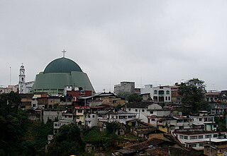
Huauchinango is a city in the far north of the state of Puebla in central Mexico. It is located in the rugged Sierra Norte de Puebla mountain region, filled with peaks, ravines and rivers that form waterfalls. The city is home to a locally venerated image called the Señor del Santo Entierro and also to the area's main commercial fair, the Feria de las Flores, which promotes the area's flower production, especially that of azaleas. It serves as the municipal seat for the surrounding municipality of the same name.

Zihuatanejo de Azueta is a municipality located on the Pacific coast in the western part of the Mexican state of Guerrero. It includes the major resort communities of Zihuatanejo and Ixtapa in addition to numerous other towns. In 2010 it had a population of 118,211 inhabitants. It has an area of 1468 km². Its municipal seat is the city of Zihuatanejo. Its municipal president for the 2005-08 period was Silvano Blanco Deaquino.

The Sierra Norte de Puebla is a rugged mountainous region accounting for the northern third of the state of Puebla, Mexico. It is at the intersection of the Trans-Mexican Volcanic Belt and the Sierra Madre Oriental, between the Mexican Plateau and the Gulf of Mexico coast. From the Mesoamerican period to the 19th century, this area was part of a larger region called Totonacapan, and area dominated by the Totonac people, extending further east to the Gulf of Mexico. Political maneuvers to weaken the Totonacs led to the region being divided between the modern states of Puebla and Veracruz with the Puebla section given its current name. Until the 19th century, the area was almost exclusively indigenous, with the four main groups still found here today, Totonacs, Nahuas, Otomis and Tepehuas, but coffee cultivation brought in mestizos and some European immigrants who took over political and economic power. While highly marginalized socioeconomically, the area has been developed heavily since the mid 20th century, especially with the building of roadways linking it to the Mexico City area and the Gulf coast.

Zacatlán is a city and municipal seat of Zacatlán Municipality located in the Sierra Norte de Puebla region of Puebla in central Mexico. The area is known for its production of apples, other fruit, cider and fruit wines, which are promoted through the annual Feria de la Manzana and Festival de la Sidra. It is also home to the Relojes Centenario company, the first clock factory in Latin America and the builder of the city's double sided flower clock in the main square. The historic center of the city is filled with traditional houses with red tile roofs and Zacatlan was designated a “Pueblo Mágico” in 2011. Outside of the city proper, there is a significant indigenous population, the Piedras Encimadas Valley with its rock formations and various waterfalls and ravines.
The Instituto Nacional para el Federalismo y el Desarrollo Municipal is a decentralised agency of the Mexican federal government. It has responsibility for promoting the ideals of federalism between the several levels of government in Mexico, by acting to coordinate and implement policies, programmes and services that are designed to strengthen inter-governmental relations between the federal and "subsidiary" levels of governance at the state and municipal levels.
El Higo is one of the 212 municipalities of the Mexican state of Veracruz. It is located in the state's Huasteca Alta region. The municipal seat is the village of El Higo, Veracruz.
Pilcaya is one of the 81 municipalities of Guerrero, in south-western Mexico. The municipal seat lies at Pilcaya. The municipality covers an area of 62.1 km².
Xochistlahuaca Municipality is one of the 81 municipalities of Guerrero, in south-western Mexico. The municipal seat lies at Xochistlahuaca. The municipality covers an area of 321.1 km².
Coyotepec is a municipality in the Mexican state of Puebla. The name comes from the Nahuatl words coyotl (coyote) and tepetl (hill)

Pahuatlán, officially Pahuatlán del Valle, is a town and municipality located in the northwest of the state of Puebla in central Mexico. The municipality is part of the Sierra Norte region of the state, a steep mountainous area which receive significant moisture from the Gulf of Mexico, and borders the states of Hidalgo and Veracruz.

Zacatlán Municipality is a municipality in Puebla in south-eastern Mexico. Its administrative centre is the city of Zacatlán.
This is a list of events that happened in 2011 in Mexico. The article also lists the most important political leaders during the year at both federal and state levels.
The Mexica New Year is the celebration of the new year according to the Aztec calendar. The date on which the holiday falls in the Gregorian calendar depends on the version of the calendar used, but it is generally considered to occur at sunrise on 12 March. The holiday is observed in some Nahua communities in Mexico. To celebrate, ocote (pitch-pine) candles are lit on the eve of the new year, along with fireworks, drumming, and singing. Some of the most important events occur in Huauchinango, Naupan, Mexico City, Zongolica, and Xicotepec.
Federal Highway 132D is the designation for toll highways paralleling Mexican Federal Highway 132. Highway 132D forms most of the Mexico City-Tuxpan highway corridor, with contiguous segments in the State of Mexico and from Tulancingo, Hidalgo to Tihuatlán, Veracruz.
| Authority control: National |
|---|
| | This article about a location in the Mexican state of Puebla is a stub. You can help Wikipedia by expanding it. |