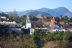
Coyomeapan | |
---|---|
Municipality and town | |
Country | Mexico |
State | Puebla |
Time zone | UTC-6 (Central Standard Time) |
• Summer (DST) | UTC-5 (Central Daylight Time) |
Coyomeapan is a town and municipality in the Mexican state of Puebla in south-eastern Mexico. [1]
Ixhuatlán del Café is a city in the Mexican state of Veracruz. It serves as the municipal seat of the municipality of the same name.
Robledillo de Trujillo is a municipality located in the province of Cáceres, Extremadura, Spain. According to the 2006 census (INE), the municipality has a population of 454 inhabitants.
Galisteo is a municipality located in the province of Cáceres, Extremadura, Spain. According to the 2006 census (INE), the municipality has a population of 2001 inhabitants.
Cosautlán in Veracruz, Mexico. It is located in the montane central zone of the State of Veracruz, about 23.5 km from state capital Xalapa. It has a surface of 72.38 km2. It is located at 19°20′N96°59′W. The town has 2224 men and 2393 women.
Rafael Lucio is a municipality located in the montane central zone of the State of Veracruz, about 9 km from state capital Xalapa. It has a surface of 24.68 km2. It is located at 19°35′N96°59′W. By Decree of November 5, 1932 Rafael Lucio's municipality and the head-board is created they are named Rafael Lucio, in honor of the illustrious doctor of Xalapa.
San Miguel Mixtepec is a town and municipality in Oaxaca in south-western Mexico. The municipality covers an area of 48.48 km². It is part of the Zimatlán District in the west of the Valles Centrales Region
San Pablo Cuatro Venados is a town and municipality in Oaxaca in south-western Mexico. The municipality covers an area of 59.96 km². It is part of the Zaachila District in the west of the Valles Centrales Region
Santiago Miltepec is a town and municipality in Oaxaca in south-western Mexico. The municipality covers an area of km². It is part of the Huajuapan District in the north of the Mixteca Region.
Santiago Tlazoyaltepec is a town and municipality in Oaxaca in south-western Mexico. The municipality covers an area of 93.13 km². It is part of the Etla District in the Valles Centrales region. As of 2005, the municipality had a total population of 4,357.
Santo Domingo Xagacía is a town and municipality in Oaxaca in south-western Mexico. It is part of the Villa Alta District in the center of the Sierra Norte Region.
Acatzingo Municipality is a municipality in the Mexican state of Puebla in south-eastern Mexico.
Cuautlancingo Municipality is a town and municipality in the Mexican state of Puebla, south-eastern Mexico. It is part of the Metropolitan area of Puebla. The town is bordered on the north by the state of Tlaxcala, Tlaxcala, east to the municipality of Tlaxcala and the city of Puebla, to the south with the municipality of San Pedro Cholula and Puebla and west by the municipality of Coronango.
Chinantla Municipality is a municipality in the Mexican state of Puebla in south-eastern Mexico.
Quimixtlán Municipality is a municipality in the Mexican state of Puebla in south-eastern Mexico.
San Salvador el Verde (municipality) is a town and municipality in the Mexican state of Puebla in south-eastern Mexico. It is best known as the site of the Chautla Hacienda, which was the property of Eulogio Gillow, the first archbishop of Antequera (city of Oaxaca) and contains an English style residence called locally called "El Castillo" (The Castle). The facility today is run as a recreation center.
Teopantlán (municipality) is a town and municipality in the Mexican state of Puebla in south-eastern Mexico.
Zongozotla Municipality is a municipality in the Mexican state of Puebla in south-eastern Mexico.
Cárdenas is a municipality in Tabasco in south-eastern Mexico.
San Juan del Río is a municipality in the Mexican state of Querétaro in central Mexico.
Tamazunchale is a town and municipality in the state of San Luis Potosí, central Mexico. In 2010 the area of the municipality was 354 square kilometres (137 sq mi) and the population was 96,820. The population of the town was 24,562.