Tuzamapan de Galeana

Last updated
Tuzamapan de Galeana
Municipality and town
Tuzamapan de Galeana Puebla.jpg
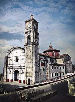
Tuzamapan de Galeana, Puebla
Mexico Puebla location map.svg
Red pog.svg
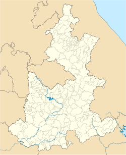
Tuzamapan de Galeana
Location of the municipality in Puebla
Mexico States blank map.svg
Red pog.svg
Tuzamapan de Galeana
Tuzamapan de Galeana (Mexico)
Coordinates: 20°05′N97°34′W / 20.083°N 97.567°W / 20.083; -97.567
CountryFlag of Mexico.svg  Mexico
State Puebla
Time zone UTC-6 (Central Standard Time)

Tuzamapan de Galeana is a town and municipality in the state of Puebla in eastern Mexico. [1] In 2020, the municipality had a population of 5,924, down 0.99% from 2010. [2]

Related Research Articles

<span class="mw-page-title-main">Nuevo León</span> State of Mexico

Nuevo León is a state in Mexico. The state was named after the New Kingdom of León, an administrative territory from the Viceroyalty of New Spain, itself was named after the historic Spanish Kingdom of León. With a total land area of 64,555 square kilometers, Nuevo León is the 13th largest federal entity in Mexico. The state is located in the northeastern part of Mexico and is bordered by Tamaulipas to the east, Coahuila to the west, and both Zacatecas and San Luis Potosi to the south. To the north, it shares an extremely narrow international border with the U.S. state of Texas. The Laredo-Colombia Solidarity International Bridge is the only vehicular bridge that connects the United States with the state of Nuevo León. It crosses over the Rio Grande between the city of Colombia, Nuevo León, and Laredo, Texas.

<span class="mw-page-title-main">Zacatepec, Morelos</span> Town and Municipality in Morelos, Mexico

Zacatepec de Hidalgo is a town in the state of Morelos, Mexico. It is bordered by Puente de Ixtla, Tlaltizapán, Tlaquiltenango and Jojutla. Miguel Hidalgo was the priest whose call to arms on September 16, 1810, led to the Mexican War of Independence.

<span class="mw-page-title-main">Municipalities of Nuevo León</span>

Nuevo León is a state in Northeast Mexico that is divided into 51 municipalities. According to the 2020 Mexican Census, it is the seventh most populated state with 5,784,442 inhabitants and the 13th largest by land area spanning 64,156.2 square kilometres (24,770.8 sq mi).

Galeana is both a municipality and a city in the Mexican state of Nuevo León. It is named after Hermenegildo Galeana, a lieutenant involved in the country's movement towards independence. Galeana shares borders with the states of Coahuila, San Luis Potosí and Zacatecas to the west; with the municipalities of Aramberri and Doctor Arroyo to the south; Rayones to the north; and with Linares, Montemorelos, Rayones and Iturbide to the east. Galeana is the largest municipality in the state, totaling 7,154.6 km², however it's scarcely populated with only 38,930 inhabitants resulting in a population density of 0.18 persons per square kilometer. Galeana, the municipal seat, is the best developed town in the region. It has services such as hospitals, accommodations, restaurants, bars and the largest drink distributor in the zone. However it remains as a low per-capita income city.

Galeana is a Mexican last name. Several municipalities in Mexico are named Galeana as a homage to Hermenegildo Galeana, a hero of the War of Independence.

<span class="mw-page-title-main">Tlalnepantla de Baz</span> Municipality in State of Mexico, Mexico

Tlalnepantla de Baz is one of 125 municipalities of the state of Mexico, north of Mexico City. The municipal seat and largest city in the municipality is the city of Tlalnepantla. Tlalnepantla comes from the Náhuatl words tlalli (land) and nepantla (middle) to mean the middle land. The city was known in prior times as Tlalnepantla de Galeana and Tlalnepantla de Comonfort, to honor Hermenegildo Galeana and Ignacio Comonfort, respectively. The current addition of Baz comes from the last name of Gustavo Baz Prada, an important politician and soldier of Emiliano Zapata's army during the Mexican Revolution. After the Revolution, Baz Prada became Governor of the State of Mexico and President of the National Autonomous University of Mexico (UNAM). It is located in the northeastern part of the state of Mexico, in the Valley of Mexico north of Mexico City proper. Together with Atizapán, it comprises the dense Region XII of Mexico State.

Copándaro is a municipality located in the Mexican state of Michoacán. The municipality has an area of 173.52 square kilometres and is bordered to the north by Huandacareo and Cuitzeo, to the east and south by Tarímbaro, and to the west by Chucándiro. The municipality had a population of 8,131 inhabitants according to the 2005 census. Its municipal seat is the city of Copándaro de Galeana.

<span class="mw-page-title-main">Galeana, Chihuahua</span> Municipality in Chihuahua, Mexico

Galeana is one of the 67 municipalities of Chihuahua, in northern Mexico. The municipal seat lies at Hermenegildo Galeana. The municipality covers an area of 1,529 km².

<span class="mw-page-title-main">Pijijiapan</span> Municipality in Chiapas, Mexico

Pijijiapan is a town and municipality in the Mexican state of Chiapas, on the coast of the Pacific Ocean about midway between the border with the state of Oaxaca and the international frontier with Guatemala.

<span class="mw-page-title-main">Casas Grandes Municipality</span> Municipio libre in Chihuahua, Mexico

Casas Grandes Municipality is located in the northern Mexican state of Chihuahua. The municipal seat is the town of Casas Grandes, Chihuahua.

<span class="mw-page-title-main">Atoyac de Álvarez (municipality)</span> Municipality in Guerrero, Mexico

Atoyac de Álvarez is one of the 81 municipalities of Guerrero, in south-western Mexico. The municipal seat lies at Atoyac de Álvarez. The municipality covers an area of 1,638.4 km2 (632.6 sq mi).

Petatlán Municipality is one of the 81 municipalities of Guerrero, in south-western Mexico. The municipal seat lies at Petatlán. The municipality covers an area of 2,071.7 km2 (799.9 sq mi).

<span class="mw-page-title-main">Tecpán de Galeana (municipality)</span> Municipality in Guerrero, Mexico

Tecpan de Galeana is one of the 81 municipalities of Guerrero, in southern Mexico. The municipal seat lies at Tecpan de Galeana. The municipality covers an area of 2,537.8 km2 (979.9 sq mi).

<span class="mw-page-title-main">Tecpán de Galeana (city)</span> Municipal seat and city in Guerrero, Mexico

Tecpan de Galeana is a city and seat of the municipality of Tecpan de Galeana, in the state of Guerrero, in southern Mexico.

<span class="mw-page-title-main">Hermenegildo Galeana, Puebla</span> Municipality and town in Puebla, Mexico

Hermenegildo Galeana is a town and municipality in the Mexican state of Puebla in south-eastern Mexico.

<span class="mw-page-title-main">Jalpa de Méndez Municipality</span> Municipality in Tabasco, Mexico

Jalpa de Méndez Municipality is a municipality in the Mexican state of Tabasco in south-eastern Mexico.

<span class="mw-page-title-main">Battle of Tecualoya</span>

The Battle of Tecualoya was a military action of the Mexican War of Independence fought between 17–20 January 1812 in the canyons of Tecualoya, Mexico. The battle was fought between the royalist forces loyal to the Spanish crown and the Mexican rebels fighting for independence from the Spanish Empire. The Mexican insurgents were commanded by General Hermenegildo Galeana and the Spanish by Rosendo Porlier y Asteguieta. The battle resulted in a victory for Spanish loyalists.

<span class="mw-page-title-main">Siege of Cuautla</span> 1812 battle of the Mexican War of Independence

<span class="mw-page-title-main">Huehuetla, Puebla</span> Municipality in Puebla, Mexico

Huehuetla is a rural municipality in Puebla, Mexico.

El Salvador is a municipality in the Mexican state of Zacatecas, located approximately 260 kilometres (160 mi) northeast of Zacatecas City, the state capital.

References

  1. "-". Enciclopedia de los Municipios de México. Instituto Nacional para el Federalismo y el Desarrollo Municipal . Retrieved January 4, 2010.
  2. "Tuzamapan de Galeana: Economía, empleo, equidad, calidad de vida, educación, salud y seguridad pública". Secretariat of the Economy. Retrieved 31 October 2023.