Cazones de Herrera, or Cazones, is a town and municipality located in the north of the Mexican state of Veracruz on the Gulf of Mexico. While it has tourist attractions along its shore, especially in the Barra de Cazones area, the municipality, including the seat, has a high level of socioeconomic marginalization. Most of the municipality's population works in agriculture.
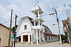
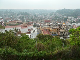
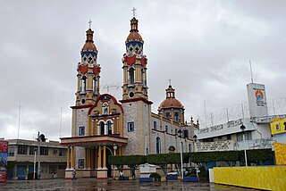
The town of Cazones de Herrera is 321km from the state capital of Xalapa.[2] It is a small town typical for the area, with a main church, main plaza, kiosk and municipal palace or government office. It is located next to the Cazones River and there is boat service from the municipal seat to communities on the other side of the river, including boats that carry vehicles.[3] While it is the largest community in the municipality with a population of 4,773 as of 2020, it has a high level of socioeconomic marginalization.[1]
The town name comes from the Spanish word for the sharpnose shark, which used to be plentiful here. The appendage “de Herrera” is in honor of soldier and politician José Joaquín de Herrera. Its municipal seal contains elements related to the area’s production of citrus fruit and corn as well as a sharpnose sharks. Other elements refer to the lands and Farallón Island at the mouth of the Cazones River.[2]
In the pre-Hispanic period, the area was part of Totonacapan, although it came under the domination of the Aztecs in the 15th century. After the Conquest, the Totonacs came to dominate the local culture again. After Independence, the area became part of the Papantla municipality. The current municipality was created in 1936 with land that formerly belonged to the municipalities of Papantla and Tuxpan, with the settlement of Cazones designated as a town. The current official name was adopted in 1956.[2]
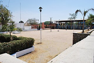
The municipality
Boats on the main docks in Barra de Cazones
The town of Cazones de Herrera is the local government for 70 other communities which cover an area of 273.1 km2.[1] It borders the municipalities of Tuxpan, Papantla, Poza Rica and Tihuatlán with the Gulf of Mexico to the east. Aside from the municipal seat, other significant communities are La Unión (1,824 hab.), Rancho Nuevo (1,238 hab.), Barra de Cazones (1,166 hab.) and Manlio Fabio Altamirano (1,121 hab.).[1] The municipal government consists of a municipal president, an officer called a “síndico”, and four representatives, called “regidors.”[2]
The municipality has an average altitude of ten meters above sea level.[2] Its main river is the Cazones, which splits the municipality into two parts and is the traditional dividing line between Totonacapan and La Huasteca.[4] The mouth of the river is here, forming the Barra (shoal) de Cazones.[2] The municipality’s shoreline faces the Gulf of Mexico and includes a number of beaches, including Playa Chaparrales, where marine turtles come to lay their eggs in March and April. The climate is hot and humid with an average annual temperature of 25C and an average rainfall of 2,000mm. The main ecosystem is high growth perennial rainforest. Remaining forests still have tropical hardwoods. The shoreline has a number of estuaries with mangroves.[4] Wildlife includes rabbits, raccoons, opossums, armadillos, and coyotes.[2] The shoreline has various estuaries with mangroves.[4] The mangroves on the river are home to various species of crab, some of which are in danger of extinction.[3]
Fields in the municipality
The area today is considered to be in the far southeast of the La Huasteca cultural region, with traditional dances belonging to this region, with danzón as the most traditional music.[2] The municipality organizes regular events to promote and preserve the traditional dances of the Veracruz Huasteca.[5] The establishment of the municipality is celebrated from June 16–23 each year. Carnival is another important annual festival.[2] The local cuisine is rich in local seafood such as shrimp, sea bass, crab, and octopus, often served with mole, adobo, and chili pepper. One notable non-seafood dish is pork served in a chili pepper and garlic sauce.[2] Just over 15% of the population speaks an indigenous language with the rest speaking Spanish.[6]
The municipality is considered to have a high level of socioeconomic marginalization. About 34% have problems obtaining sufficient food; 45% have problems obtaining sufficient education or job training and about 70% lack their own land.[7] Of the municipality’s 71 communities, fifty are considered to be highly or very highly marginalized.[6] As of the 2010 census, there were 5,991 residences.[2] About 58% have running water, and less than 47% have drainage. Over 96% have electricity and access to a landfill. Seventy percent of homes have cement floors with 24% having dirt floors. About 15% have autos, 86% have televisions, 70% have refrigerators, 69% have radios, 34% have cell phones, just over five percent have computers, and less than two percent have Internet.[7] About 54% of the working population of the municipality is involved in agriculture, fishing, and forestry. Principle crops include corn, oranges, bananas, green chili peppers, and grapefruit. Most livestock is cattle, followed by pigs, sheep, goats, and domestic fowl. About 12 percent is involved in mining, construction, and utilities. About 32% is involved in commerce and services, including tourism.[8]
View of Playa ChaparralesWild turkeys in Cazones
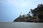
Tourist attractions in the municipality are related to its shoreline and includes beaches such as Playa Azul, Playa Boquitas, Playa Sur, and Playa Chaparrales, as well as the Cazones River.[2] The best known area is Barra de Cazones, where almost all of the municipality’s hotels are.[8] The community centers on the main boardwalk and docks which were built by the state in 2006. The Cazones lighthouse was built in the 1970s to guide small vessels such as fishing boats.[5] Farallón is a small island located at the mouth of the Cazones River about half a kilometer from the ocean. In the colonial period, it was a refuge for pirates. One side of the island has a cliff called “El Chivo” eighteen meters high, which is popular for rappelling.[5][3] The island is home to a species of black iguana called “garrobo negro.” Playa Sur is the best known beach because of its hotels and other tourist infrastructure.[3]
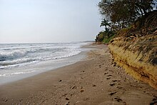
Playa Norte is a virgin beach with no permanent structures located on the opposite side of the mouth of the Cazones River from the main docks. The area is a haven for flocks of sea gulls and parts are filled with sea shells and pieces of coral. One of the features of this beach is “El Pulpo” (The Octopus), a rock formation with six branches formed by erosion from sea waves. Another is the Cueva del Tigre (Tiger Cave) a small cave which is hidden during high tide.[3]
View of the Cazones River
Playa Chaparrales is a semi-virgin beach with permanent structures generally out of view of the shoreline. This beach has heaps of shells pushed onshore in capricious formations. It is a protected nesting site for three of Mexico’s protected marine species. Visitors are welcome to the beach during nesting periods which are guarded by government officials.[3]
Playa Azul is a semi virgin beach which contains an estuary called El Tejón.[3]
Playa Boquillas is named after the Boquillas River estuary.[3]
Arrecife Blake (Blake Reef) is also called the “Bajo Negro” (Black Low) because it is home to species of black coral. It also has expanses of mangroves.[3] La Encantada is a cave which is home to a small species of bat.[3]
There are 71.1km of highway in the municipality, almost all of which is maintained by the state.[8]
The municipality has thirty two preschools, one special education facility, forty two primary schools, sixteen middle schools, and nine high schools. There are no facilities of higher education. There are seventeen public libraries. There is a rate of just over fifteen percent illiteracy as of 2010. Just over 19% have not finished primary school.[7]
The National Triathlon of Cazones is a major annual sporting event in the north of Veracruz, sponsored by the municipality and the federal government. Money raised from the event is used to help preserve marine turtle habitats.[3]
Veracruz, formally Veracruz de Ignacio de la Llave, officially the Estado Libre y Soberano de Veracruz de Ignacio de la Llave, is one of the 31 states which, along with Mexico City, comprise the 32 Federal Entities of Mexico. Located in eastern Mexico, Veracruz is bordered by seven states, which are Tamaulipas, San Luis Potosí, Hidalgo, Puebla, Oaxaca, Chiapas, and Tabasco. Veracruz is divided into 212 municipalities, and its capital city is Xalapa-Enríquez.
Boca del Río is a city and municipality located in the center of the Mexican state of Veracruz. The small city of Boca del Río serves as the seat of the municipality. The municipality lies just south of the municipality of Veracruz, and contains a part of the city and city and port of Veracruz. It is a port in its own right, as well as the metropolitan area's center for business travel and upscale hotels and restaurants. The city contains two museums, one dedicated to Agustín Lara and the other a military ship that has been converted into a museum. However, the municipality's main feature is the World Trade Center Veracruz, which hosts business meetings, conferences and conventions.
Papantla is a city and municipality located in the north of the Mexican state of Veracruz, in the Sierra Papanteca range and on the Gulf of Mexico. The city was founded in the 13th century by the Totonacs and has dominated the Totonacapan region of the state since then. The region is famed for vanilla, which occurs naturally in this region, the Danza de los Voladores and the El Tajín archeological site, which was named a World Heritage Site. Papantla still has strong communities of Totonacs who maintain the culture and language. The city contains a number of large scale murals and sculptures done by native artist Teodoro Cano García, which honor the Totonac culture. The name Papantla is from Nahuatl and most often interpreted to mean "place of the papanes". This meaning is reflected in the municipality's coat of arms.
Poza Rica, formally: Poza Rica de Hidalgo is a city and its surrounding municipality in the Mexican state of Veracruz. Its name means "rich well/pond". It is often thought that the name came to be because it was a place known for its abundance of oil. In reality, before oil was discovered, there existed a pond rich in fish, which gave origin to the city’s name. In the 20th century oil was discovered in the area. It has since been almost completely extracted. This has resulted in the decline of oil well exploration and drilling activities, though there are still many oil facilities.
Zihuatanejo, and/or Ixtapa-Zihuatanejo, is the fourth largest city in the Mexican state of Guerrero. It was known by 18th-century English mariners as Chequetan and/or Seguataneo. Politically the city belongs to the municipality of Zihuatanejo de Azueta in the western part of Guerrero, but both are commonly referred to as Zihuatanejo. It is on the Pacific Coast, about 240 km northwest of Acapulco. Zihuatanejo belongs to a section of the Mexican Pacific Coast known as the Costa Grande. This town has been developed as a tourist attraction along with the modern tourist resort of Ixtapa, 5 km (3.1 mi) away. However, Zihuatanejo has kept its traditional town feel. The town is located on a well-protected bay which is popular with private boat owners during the winter months.
Totonacapan refers to the historical extension where the Totonac people of Mexico dominated, as well as to a region in the modern states of Veracruz and Puebla. The historical territory was much larger than the currently named region, extending from the Cazones River in the north to the Papaloapan River in the south and then west from the Gulf of Mexico into what is now the Sierra Norte de Puebla region and into parts of Hidalgo. When the Spanish arrived, the Totonac ethnicity dominated this large region, although they themselves were dominated by the Aztec Empire. For this reason, they allied with Hernán Cortés against Tenochtitlán. However, over the colonial period, the Totonac population and territory shrank, especially after 1750 when mestizos began infiltrating Totonacapan, taking political and economic power. This continued into the 19th and 20th centuries, prompting the division of most of historical Totonacpan between the states of Puebla and Veracruz. Today, the term refers only to a region in the north of Veracruz where Totonac culture is still important. This region is home to the El Tajín and Cempoala archeological sites as well as Papantla, which is noted for its performance of the Danza de los Voladores.
Cuajinicuilapa is the head town of the municipality of the same name in the Costa Chica region of the Mexican state of Guerrero. A low-lying area, it borders the Pacific Ocean and the state of Oaxaca. The municipality has the state's largest population of Afro-Mexicans with most of the population of this ethnicity. The town and municipality are highly socioeconomically marginalized and it is the poorest municipality of the state, with the economy dependent on livestock and fishing.
Soconusco is a region in the southwest corner of the state of Chiapas in Mexico along its border with Guatemala. It is a narrow strip of land wedged between the Sierra Madre de Chiapas mountains and the Pacific Ocean. It is the southernmost part of the Chiapas coast extending south from the Ulapa River to the Suchiate River, distinguished by its history and economic production. Abundant moisture and volcanic soil has always made it rich for agriculture, contributing to the flowering of the Mokaya and Olmec cultures, which were based on Theobroma cacao and rubber of Castilla elastica.
Boquillas or Boquilla or variant, may refer to:
La Huasteca is a geographical and cultural region located partially along the Gulf of Mexico and including parts of the states of Tamaulipas, Veracruz, Puebla, Hidalgo, San Luis Potosí, Querétaro and Guanajuato. It is roughly defined as the area in which the Huastec people had influence when their civilization was at its height during the Mesoamerican period. Today, the Huastecs occupy only a fraction of this region with the Nahua people now the most numerous indigenous group. However, those who live in the region share a number of cultural traits such as a style of music and dance, along with religious festivals such as Xantolo.
Tecolutla is a town and municipality located on the Tecolutla River on the eastern coast of the state of Veracruz in Mexico. It has the closest beaches to Mexico City, and much of its economy is based on tourism, as it is only a four- or five-hour drive from the capital. It is the northern end of a tourist corridor along the Gulf of Mexico called the "Emerald Coast," which extends down to the city of Veracruz.
The Sierra Norte de Puebla is a rugged mountainous region accounting for the northern third of the state of Puebla, Mexico. It is at the intersection of the Trans-Mexican Volcanic Belt and the Sierra Madre Oriental, between the Mexican Plateau and the Gulf of Mexico coast. From the Mesoamerican period to the 19th century, this area was part of a larger region called Totonacapan, and area dominated by the Totonac people, extending further east to the Gulf of Mexico. Political maneuvers to weaken the Totonacs led to the region being divided between the modern states of Puebla and Veracruz with the Puebla section given its current name. Until the 19th century, the area was almost exclusively indigenous, with the four main groups still found here today, Totonacs, Nahuas, Otomis and Tepehuas, but coffee cultivation brought in mestizos and some European immigrants who took over political and economic power. While highly marginalized socioeconomically, the area has been developed heavily since the mid 20th century, especially with the building of roadways linking it to the Mexico City area and the Gulf coast.
The Costa Chica of Guerrero is an area along the south coast of the state of Guerrero, Mexico, extending from just south of Acapulco to the Oaxaca border. Geographically, it consists of part of the Sierra Madre del Sur, a strip of rolling hills that lowers to coastal plains to the Pacific Ocean. Various rivers here form large estuaries and lagoons that host various species of commercial fish.
Catemaco Municipality is a municipality in the Mexican state of Veracruz. It is located in the state's Los Tuxtlas region. The municipal seat is the city of Catemaco.
Paraíso is a town and municipality located in the north of the Mexican state of Tabasco, about 75 km due north of the state capital of Villahermosa on the Gulf of Mexico. Much of the area is traditionally dedicated to fishing and agriculture. Today, it is also an oil-producing area with the mostly oil-dedicated port of Dos Bocas. There is also some tourism connected to the area's beaches and natural attractions, and the area is promoted under the state's Cacao Route tourism program.
Tihuatlán is a city and its surrounding municipality located in the north of the Mexican state of Veracruz, about 316 km (196 mi) from the state capital Xalapa. The municipality has a surface of 828.29 km2 (319.80 sq mi). The municipality has a population of 92,726 inhabitants as 2020, however, only 16 % resides in the municipal seat.
Pahuatlán, officially Pahuatlán del Valle, is a town and municipality located in the northwest of the state of Puebla in central Mexico. The municipality is part of the Sierra Norte region of the state, a steep mountainous area which receive significant moisture from the Gulf of Mexico, and borders the states of Hidalgo and Veracruz.
Huatusco is an archaeological site located in the Carrillo Puerto municipality, near the small, almost deserted town of Santiago Huatusco, on the northern bank of the Rio Atoyac in the Rancho El Fortin. The importance of the site due to the nearly undamaged pyramid from prehispanic times, the largest part of the actual temple is still standing, in the state of Veracruz, Mexico.
The Tecolutla River is a river in the state of Veracruz in Mexico, and the main drainage of the historical and cultural region of Totonacapan. It is principally fed by four rivers that rise in the Sierra Norte de Puebla: from north to south, they are the Necaxa, the Lajajalpan, the Tecuantepec and the Apulco. These rivers converge in the municipality of Espinal, Veracruz, and from here the Tecolutla flows about 100 kilometres (62 mi) east through the coastal plain and the municipalities of Papantla and Gutiérrez Zamora to its mouth at the town of Tecolutla on the Gulf of Mexico, On its south bank the Tecolutla receives the Joloapan River near Paso del Correo, and the Chichicatzapan River via the Ostiones estuary near its mouth.
The Totonac culture or Totonec culture was a culture that existed among the indigenous Mesoamerican Totonac people who lived mainly in Veracruz and northern Puebla. Originally, they formed a confederation of cities, but, in later times, it seems that they were organized in three dominions: North, South and Serran. Its economy was agricultural and commercial. They had large urban centers such as: El Tajín (300–1200), which represents the height of the Totonac culture, Papantla (900–1519) and Cempoala (900–1519).
1 2 3 4 5 6 7 8 9 10 11 12 "Cazones de Herrera". Enciclopedia de los Municipios y Delegaciones de México Veracruz (in Spanish). Mexico: ) INAFED Instituto para el Federalismo y el Desarrollo Municipal and SEGOB Secretaría de Gobernación. 2010. Retrieved March 23, 2012.
1 2 3 4 5 6 7 8 9 10 11 "Barra de Cazones". Pata de Perro (in Spanish). 1 (9). Mexico City: Global Edition Co. SA de CV: 20–24. 2011.
This page is based on this Wikipedia article Text is available under the CC BY-SA 4.0 license; additional terms may apply. Images, videos and audio are available under their respective licenses.