Xoxocotla, Veracruz

Last updated
Xoxocotla
Municipality

Paisajes de Xoxocotla Ver - panoramio.jpg

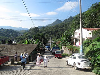
View of the municipal seat of Xoxocotla
Mexico Veracruz Xoxocotla location map.svg
Location in Veracruz
Mexico States blank map.svg
Red pog.svg
Xoxocotla
Location in Mexico
Coordinates: 18°38′48″N97°09′01″W / 18.64667°N 97.15028°W / 18.64667; -97.15028 Coordinates: 18°38′48″N97°09′01″W / 18.64667°N 97.15028°W / 18.64667; -97.15028 [1]
CountryFlag of Mexico.svg  Mexico
State Flag of Veracruz.svg  Veracruz
Established 30 November 1870
Seat Xoxocotla
Government [2]
  President Magdaleno Juárez Pérez
Area [3]
  Total 37.398 km2 (14.439 sq mi)
Elevation [1] (of seat) 2,099 m (6,886 ft)
Population (2010 Census) [3]
  Total 5,163
  Estimate (2015 Intercensal Survey) [4] 5,446
  Density 140/km2 (360/sq mi)
  Seat 2,362
Time zone Central (UTC-6)
  Summer (DST) Central (UTC-5)
Postal codes 94820–94825 [5]
Area code 278
Website Official website

Xoxocotla ( Loudspeaker.svg   pronunciation  ; Nahuatl: "place of green pines" or "place of old ocotes" [2] ) is a municipality in the Mexican state of Veracruz, located 103 kilometres (64 mi) south of the state capital Xalapa.

Nahuatl, known historically as Aztec, is a language or group of languages of the Uto-Aztecan language family. Varieties of Nahuatl are spoken by about 1.7 million Nahua peoples, most of whom live in central Mexico.

Ocote is a common name for various species of pine trees in the genus Pinus that occur in the Spanish speaking Americas—Latin America.

Municipalities are the second-level administrative divisions of Mexico, where the first-level administrative division is the state. As of the establishment of two new municipalities in Chiapas in September 2017, there are 2,448 municipalities in Mexico, not including the 16 delegaciones of Mexico City. The internal political organization and their responsibilities are outlined in the 115th article of the 1917 Constitution and detailed in the constitutions of the states to which they belong.

Contents

Geography

The municipality of Xoxocotla is located in the Sierra de Zongolica, which are foothills of the Sierra Madre Oriental in central Veracruz. It lies at an altitude between 2,100 and 2,700 metres (6,900–8,900 ft). It borders the Veracruzian municipalities of Soledad Atzompa to the northwest, Atlahuilco to the northeast, and Tlaquilpa to the east, as well as the municipality of Vicente Guerrero in the state of Puebla to the south. [6] The municipality covers an area of 37.398 square kilometres (14.439 sq mi) [3] and comprises 0.05% of the state's area. [1]

Sierra Madre Oriental mountain range in Mexico

The Sierra Madre Oriental is a mountain range in northeastern Mexico. The Sierra Madre Oriental is part of the American Cordillera, a chain of mountain ranges (cordillera) that consists of an almost continuous sequence of mountain ranges that form the western "backbone" of North America, Central America, South America and Antarctica.

Soledad Atzompa is a village in the mountainous central zone in the State of Veracruz, about 90 km south-east of the state capital Xalapa. It has an area of 65.80 km2 and stands at an elevation of 2260 metres above sea level

Atlahuilco is a municipality in Veracruz, Mexico. It is located about 131 km from state capital Xalapa. It has a surface of 64.98 km2. It is located at 18°42′N97°05′W.

The land in Xoxocotla is divided between farmland (50%), forest (44%) and urban areas (6%). Soils in the municipality consist of luvisols (73%) and regosols (21%). The municipality is drained by tributaries of the Blanco River, which itself drains into Alvarado Lagoon at the mouth of the Papaloapan River. [6]

Regosol

A Regosol in the World Reference Base for Soil Resources (WRB) is very weakly developed mineral soil in unconsolidated materials. Regosols are extensive in eroding lands, in particular in arid and semi-arid areas and in mountain regions. Internationally, Regosols correlate with soil taxa that are marked by incipient soil formation such as Entisols in the USDA soil taxonomy or Rudosols and possibly some Tenosols in the Australian Soil Classification.

Papaloapan River river in Mexico

The Papaloapan River is one of the main rivers of the Mexican state of Veracruz. Its name comes from the Nahuatl papaloapan meaning "river of the butterflies".

Xoxocotla has a temperate climate with rain in the summer. Average temperatures in the municipality range between 12 and 18 °C (54–64 °F), and average annual precipitation ranges between 100 and 1,100 millimetres (3.9–43.3 in). [6]

History

The municipality of was incorporated on 30 November 1870, forming part of the canton of Zongolica in the state of Veracruz. It became a free municipality on 15 January 1918. [7]

Administration

The municipal government comprises a president, a councillor (Spanish: síndico), and a trustee (regidor). [2] The current president of the municipality is Magdaleno Juárez Pérez. [8]

Spanish language Romance language

Spanish or Castilian, is a Western Romance language that originated in the Castile region of Spain and today has hundreds of millions of native speakers in the Americas and Spain. It is a global language and the world's second-most spoken native language, after Mandarin Chinese.

Demographics

In the 2010 Mexican Census, the municipality of Xoxocotla recorded a population of 5163 inhabitants living in 1137 households. [9] The 2015 Intercensal Survey estimated a population of 5446 inhabitants in Xoxocotla, 92.29% of whom reported being of Indigenous ancestry and 37.33% of whom reported being of African ancestry. [4] In the 2010 Census, 1163 people or 23% of the population in Xoxocotla reported speaking an Indigenous language, 1118 of which spoke Nahuatl. [1]

There are 17 localities in the municipality, [1] of which only the municipal seat, also called Xoxocotla, is classified as urban. It recorded a population of 2362 inhabitants in the 2010 Census. [9]

Economy

Important economic activities in Xoxocotla include pig farming and the growing of corn and beans. [10]

Related Research Articles

Lerdo de Tejada Municipality in Veracruz, Mexico

Lerdo de Tejada is a municipality in the Mexican state of Veracruz, located 207 kilometres (129 mi) southeast of the state capital Xalapa. It is named after Sebastián Lerdo de Tejada, the 27th President of Mexico.

Xoxocotla, Morelos Municipality and town in Morelos, Mexico

Xoxocotla is a town located in the southern part of the state of Morelos, about 30 km south of the state capital Cuernavaca. The name comes from the Nahuatl language, Xoxo-oco-tlan: “place where there are green pines". Formerly part of Puente de Ixtla, it became its own indigenous municipality on 1 January 2019. It recorded a population of 21,074 inhabitants in the 2010 Mexican census.

Huehuetla, Puebla Municipality in Puebla, Mexico

Huehuetla is a rural municipality in Puebla, Mexico.

Tlaxco Municipality, Tlaxcala Municipality in Tlaxcala, Mexico

Tlaxco is a municipality in Tlaxcala, Mexico.

Mazapil Municipality Municipality in Zacatecas, Mexico

Mazapil is a municipality in the Mexican state of Zacatecas and the state's largest municipality by area. The Peñasquito mine, Mexico's largest gold mine, is located in this sparsely populated municipality.

Río Grande Municipality, Zacatecas Municipality in Zacatecas, Mexico

Río Grande is a municipality in the Mexican state of Zacatecas.

Comapa, Veracruz Municipality in Veracruz, Mexico

Comapa is a municipality in the Mexican state of Veracruz, located about 40 kilometres (25 mi) south of the state capital Xalapa.

Jilotepec, Veracruz Municipality in Veracruz, Mexico

Jilotepec is a municipality in the Mexican state of Veracruz, located 11 kilometres (6.8 mi) north-northwest of the state capital Xalapa.

Las Minas, Veracruz Municipality in Veracruz, Mexico

Las Minas is a municipality in the Mexican state of Veracruz, located 28 kilometres (17 mi) northeast of the state capital Xalapa.

Los Reyes, Veracruz Municipality in Veracruz, Mexico

Los Reyes is a municipality in the Mexican state of Veracruz, located about 100 kilometres (62 mi) south of the state capital Xalapa.

Naranjal, Veracruz Municipality in Veracruz, Mexico

Naranjal is a municipality in the Mexican state of Veracruz, located 10 kilometres (6.2 mi) south of the city of Córdoba.

Tepetzintla, Veracruz Municipality in Veracruz, Mexico

Tepetzintla is a municipality in the Mexican state of Veracruz, located 207 kilometres (129 mi) northwest of the state capital of Xalapa and 119 kilometres (74 mi) south of the city of Tampico.

Citlaltépetl, Veracruz Municipality in Veracruz, Mexico

Citlaltépetl is a municipality in the Mexican state of Veracruz, located 223 kilometres (139 mi) northwest of the state capital of Xalapa and 99 kilometres (62 mi) south of the city of Tampico, Tamaulipas.

Tomatlán, Veracruz Municipality in Veracruz, Mexico

Tomatlán is a municipality in the Mexican state of Veracruz, located 58 kilometres (36 mi) south of the state capital of Xalapa.

Zacualpan, Veracruz Municipality in Veracruz, Mexico

Zacualpan is a municipality in the Mexican state of Veracruz, located 179 kilometres (111 mi) northwest of the state capital of Xalapa and 56 kilometres (35 mi) northeast of the city of Pachuca, Hidalgo.

Zaragoza, Veracruz Municipality in Veracruz, Mexico

Zaragoza is a municipality in the Mexican state of Veracruz, located 297 kilometres (185 mi) southeast of the state capital of Xalapa and 10 kilometres (6.2 mi) southwest of the city of Minatitlán.

Carácuaro Municipality in Michoacán, Mexico

Carácuaro is a municipality in the Mexican state of Michoacán, located 77 kilometres (48 mi) south of the state capital of Morelia.

Churintzio Municipality in Michoacán, Mexico

Churintzio is a municipality in the Mexican state of Michoacán, located 104 kilometres (65 mi) northwest of the state capital of Morelia.

Cojumatlán de Régules Municipality in Michoacán, Mexico

Cojumatlán de Régules is a municipality in the Mexican state of Michoacán, located 180 kilometres (110 mi) west of the state capital of Morelia.

Contepec Municipality in Michoacán, Mexico

Contepec is a municipality in the Mexican state of Michoacán, located 110 kilometres (68 mi) east of the state capital of Morelia.

References

  1. 1 2 3 4 5 "Sistema Nacional de Información Municipal" (in Spanish). SEGOB. 2010. Retrieved 5 March 2018.
  2. 1 2 3 "Xoxocotla". Enciclopedia de los Municipios y Delegaciones de México (in Spanish). INAFED . Retrieved 5 March 2018.
  3. 1 2 3 "Xoxocotla: Datos generales". Cédulas de información municipal (in Spanish). SEDESOL. 2013. Retrieved 5 March 2018.
  4. 1 2 Panorama sociodemográfico de Veracruz de Ignacio de la Llave 2015 (PDF) (in Spanish). INEGI. 2016. p. 226. ISBN   978-607-739-871-4 . Retrieved 5 March 2018.
  5. "Consulta Códigos Postales". Catálogo Nacional de Códigos Postales. Mexican Postal Service. 23 February 2018. Retrieved 5 March 2018.
  6. 1 2 3 "Compendio de Información Geográfica Municipal 2010: Xoxocotla, Veracruz de Ignacio de la Llave" (in Spanish). INEGI. Retrieved 5 March 2018.
  7. Estado de Veracruz-Llave. División Territorial de 1810 a 1995 (PDF) (in Spanish). Mexico: INEGI. 1996. pp. 121, 315. ISBN   970-13-1517-0.
  8. Huerta, Verónica (14 December 2017). "Aceptan alcaldes de Morena formar parte del Grupo de Coordinación Veracruz" (in Spanish). Formato 7. Retrieved 5 March 2018.
  9. 1 2 "Resumen municipal: Municipio de Xoxocotla". Catálogo de Localidades (in Spanish). SEDESOL. Retrieved 5 March 2018.
  10. "Cuadernillos municipales, 2016: Xoxocotla" (PDF) (in Spanish). SEFIPLAN Veracruz. p. 6. Retrieved 5 March 2018.