
Xalapa or Jalapa, officially Xalapa-Enríquez, is the capital city of the Mexican state of Veracruz and the name of the surrounding municipality. In the 2005 census the city reported a population of 387,879 and the municipality of which it serves as municipal seat reported a population of 413,136. The municipality has an area of 118.45 km2. Xalapa lies near the geographic center of the state and is the second-largest city in the state after the city of Veracruz to the southeast.

San Fernando del Valle de Catamarca is the capital and largest city in Catamarca Province in northwestern Argentina, on the Río Valle River, at the feet of the Cerro Ambato. The city name is normally shortened as Catamarca.

Resistencia is the capital and largest city of the province of Chaco in north-eastern Argentina. According to the 2010 census, the population of the city proper was 291,720 inhabitants. It is the anchor of a larger metropolitan area, Greater Resistencia, which comprises at least three more municipalities for a total population of 387,340 as of 2010. This conurbation is the largest in the province, and the eleventh most populous in the country. It is located along the Negro River, a tributary of the much larger Paraná River, opposite the city of Corrientes, Corrientes Province.
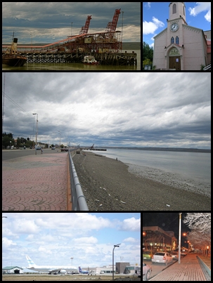
Río Gallegos is the capital and largest settlement of the Patagonian province of Santa Cruz in Argentina. Located in the department of Güer Aike, it has a population of about 98,000, according to the 2010 census [INDEC], a 24% increase from the 79,000 in the 2001 census [INDEC]. The city bears the name of the Gallegos River, and sits on its estuary 2,636 km (1,638 mi) south from the Argentinian federal capital Buenos Aires.

Ciudad Guzmán is a city in the Mexican state of Jalisco. It is 124 kilometres (77 mi) south of Guadalajara, at a height of 1,507 metres (4,944 ft) above sea level. Its population totaled 97,750 in the 2010 census, ranking as the eighth-largest city in the state.

Paraná is the capital city of the Argentine province Entre Ríos, located on the eastern shore of the Paraná River, opposite the city of Santa Fe, capital of the neighbouring Santa Fe Province. The city has a population of 247,863.

Tuxpan is both a municipality and city located in the Mexican state of Veracruz. The population of the city was 78,523 and of the municipality was 134,394 inhabitants, according to the INEGI census of 2005, residing in a total area of 1,051.89 km2 (406.14 sq mi). The municipality includes many smaller outlying communities, the largest of which are Alto Lucero and Santiago de la Peña. A local beachside community is also nearby.

Ramos Arizpe is a city and seat of the surrounding municipality of the same name in the Mexican state of Coahuila. Ramos Arizpe is located 11 km from the state capital of Saltillo. It is part of the Saltillo metropolitan area. The city reported a population of 48,228 in the 2005 census; the municipality had a population of 56,708. Its area is 5,306.6 km2.

Apizaco is a city in Apizaco Municipality located near the geographic center of the Mexican state of Tlaxcala, approximately 25 minutes by car from the state's capital city of Tlaxcala. The city gets its name from the Nahuatl language words "ātl" (water), "pitzāhuac" (thin), and the suffix "co" (place), forming "Āpitzāco", or roughly "thin water place". Those seeking to reach the port of Veracruz by railroad from Mexico City must travel through Apizaco. The city began because of its location on this railroad.

Huejutla de Reyes is a city and one of the 84 municipalities of Hidalgo, in central-eastern Mexico. The name comes from the Nahuatl huexotl ("willow") and tlan ("place"), while "de Reyes" commemorates local cobbler Antonio Reyes Cabrera who died defending Huejutla from French invaders in 1866.
Lerdo de Tejada is a municipality in the Mexican state of Veracruz, located 207 kilometres (129 mi) southeast of the state capital Xalapa. It is named after Sebastián Lerdo de Tejada, the 27th President of Mexico.
Comapa is a municipality in the Mexican state of Veracruz, located about 40 kilometres (25 mi) south of the state capital Xalapa.

Jilotepec is a municipality in the Mexican state of Veracruz, located 11 kilometres (6.8 mi) north-northwest of the state capital Xalapa.
Las Minas is a municipality in the Mexican state of Veracruz, located 28 kilometres (17 mi) northeast of the state capital Xalapa.

Citlaltépetl is a municipality in the Mexican state of Veracruz, located 223 kilometres (139 mi) northwest of the state capital of Xalapa and 99 kilometres (62 mi) south of the city of Tampico, Tamaulipas.

Zacualpan is a municipality in the Mexican state of Veracruz, located 179 kilometres (111 mi) northwest of the state capital of Xalapa and 56 kilometres (35 mi) northeast of the city of Pachuca, Hidalgo.

Senguio is a municipality in the Mexican state of Michoacán, located approximately 90 kilometres (56 mi) east of the state capital of Morelia.
Saín Alto is a municipality in the Mexican state of Zacatecas, located approximately 110 kilometres (68 mi) northwest of the state capital of Zacatecas City.

Villa González Ortega is a municipality in the Mexican state of Zacatecas, located approximately 70 kilometres (43 mi) southeast of the state capital of Zacatecas City. It is named after Jesús González Ortega.

Luis Moya is a municipality in the Mexican state of Zacatecas, located approximately 50 kilometres (31 mi) southeast of the state capital of Zacatecas City. It is named after Luis Moya (1855–1911), a colonel in the Mexican Revolution who was posthumously given the rank of brigadier general in 1939.