Tres Valles

Last updated
Tres Valles
Escudo Tres Valles.svg
Localizacion Tres Valles.svg
Location of Tres Valles within Veracruz State
Mexico States blank map.svg
Red pog.svg
Tres Valles
Location of Tres Valles within Mexico
Coordinates: 18°10′N96°01′W / 18.167°N 96.017°W / 18.167; -96.017
CountryFlag of Mexico.svg  Mexico
State Veracruz
Region Papaloapan
Municipality Tres Valles
Government
   Mayor José Manuel Díaz Rodríguez
Area
  Total378.1 km2 (146.0 sq mi)
Elevation
40 m (130 ft)
Population
 (2010)
  Total45 097
  Density82.3/km2 (213/sq mi)
Time zone UTC-6 (CST)
  Summer (DST) UTC-5 (CDT)
Postal code
95300
Area code 288
Website http://www.tresvalles.gob.mx/

Tres Valles (Three Valleys) is a town and municipality in the Mexican state of Veracruz, created as a free municipality by decree on November 25, 1988. It is located in the lower reaches of the Papaloapan, and borders the state of Oaxaca and the towns of Tierra Blanca and Cosamaloapan.

Contents

Monument of Miguel Hidalgo y Costilla Estatua Miguel Hidalgo.jpg
Monument of Miguel Hidalgo y Costilla

The main source of income is agriculture, particularly sugar cane cultivation, but rice, corn, beans, pineapples, sorghum, and mangoes are also grown here.

Etymology

The historical origin of the name Three Valleys is uncertain, but the generally accepted version is that it was named after three valleys in the region: Valle Nacional, the Valley of Tesechoacán (currently José Azueta) and Playa Vicente. The earliest known version of the "Three Valleys" dates from 1962.

History

Prehispanic era

Approximate territory under jurisdiction of Puctlancingo in the 16th century. Puctlancingo Territorio Siglo XVI.jpg
Approximate territory under jurisdiction of Puctlancingo in the 16th century.

This area of the lower Papaloapan was populated primarily by the Olmec, who disappeared for unknown reasons. Later, the area was inhabited by the Totonac, from approximately 500–100 BCE. By the time the Spanish arrived, the area had been conquered by the Mexicas, as with much of the Mesoamerican peoples.

The current municipality of Tres Valles was divided between the jurisdictions of Cosamaloapan and Puctlancingo, but the only people on record within the current limits were the Puctlancingo, located at the confluence of the Amapa and Tonto rivers. It is likely that there were other small settlements at the time of conquest. A 1584 map showed a hill with ruins called Quateupan south of the Coapilla creek, near the river Tonto.

Colonial period

After the fall of Tenochtitlan, Cortés sent Gonzalo de Sandoval to the conquest of the Tuxtepec garrison. Achieving his mission, he subjected the people of the Papaloapan basin to the encomienda system. Cosamaloapan joined the jurisdiction of the district of Guaspaltepec to form one corregimiento (township).

In 1600, Tuxtepec and Puctlancingo were added to the congregation of the province Guaspaltepec. That same year, Guaspaltepec was abandoned, its inhabitants were living in Mixtlan, the head priest moved to Chacaltianguis and the fate of the township was in the air. After the disappearance of Guaspaltepec the district came under the power of Cosamaloapan.

In 1786 the Spanish crown ordered the creation of the Municipality of Veracruz. The area remained a Canton until 1917. Consequently, the municipality became important for political and administrative organization.

Foundation

Monument to Miguel Hidalgo Placa Monumento Miguel Hidalgo.JPG
Monument to Miguel Hidalgo

November 21, 1907, is considered the founding date of the city of Tres Valles. However, the exact date is unknown. The earliest record with that date in 1982, when a commemorative monument to Miguel Hidalgo was placed in the city's central park. It seems that during the process of building the monument, the date was established. There's also a document dated November 24, 1939, stating that the founding was "32 years ago", that is, around 1907.

According to historians the settlement has existed since at least 1900, when a camp was created for builders of the Pacific Veracruz railway. The only relevant fact pointing to this period is the 1907 arrival of the Martinez family, owners of the land where the town was settled. Perhaps this and other facts have survived in the collective memory and over the passage of time, this has become the year considered the foundation of the community.

Mexican Revolution

Post-Revolutionary era

In 1921, Three Valleys had a population of 791 persons (399 men and 392 women).

In 1924, the first school was established (which now houses the School "March 18") which was directed by Prof. "Nacha", originally from Tierra Blanca, Veracruz. It was built by Ignacio Martinez, who also donated the land.

Also in 1924, Martinez built the first Catholic chapel, in honor of Our Lady of Guadalupe. This location is now the Municipal Agency, as the chapel was stripped during the Cristero War.

The banana boom ended with the plague the Sigatoka fungus. Soon after came the expropriation of the three banana companies, decreed by President Lázaro Cárdenas, which were merged into the "Transcontinental" company.

Geography

Geographical Maps of Tres Valles
Hidrografia de Tres Valles.svg Tres Valles climas predominantes.svg
hidrologíaClimas

Location

The municipal territory covers an area of approximately 378.1km2, and is located in the south-central area of Veracruz, bounded by 96 ° 01 'and 96 ° 18' west of Greenwich and between 18 ° 10 '18 25' north latitude, in the region of Papalopan, between the state of Oaxaca and the towns of Tierra Blanca and Cosamaloapan.

Hydrography

The main rivers are the Amapa and Tonto, followed in importance by the Hondo, Mondongo, the Coyote, Zapote, and Jobo.

Climate

Tres Valles has a warm humid climate, with winter rainfall makingup less than 5% of the annual rainfall. The rainy season is in autumn, and June is the hottest month of the year. There is no weather station in the municipality, and the nearest station is in located in Ciudad Alemán.

Climate data for CD. Alemán, Veracruz
MonthJanFebMarAprMayJunJulAugSepOctNovDecYear
Record high °F97.7103.1107.6109.4113.9112.1104.0101.3102.299.596.895.0113.9
Average high °F81.183.589.693.996.893.290.790.789.887.484.681.988.5
Average low °F63.063.767.170.773.974.172.772.772.970.968.064.969.6
Record low °F50.032.051.857.264.466.266.266.265.358.154.545.532.0
Average precipitation inches1.371.070.831.064.0913.0416.5714.9514.206.333.261.8678.63
Record high °C36.539.542.043.045.544.540.038.539.037.536.035.045.5
Average high °C27.328.632.034.436.034.032.632.632.130.829.227.731.4
Average low °C17.217.619.521.523.323.422.622.622.721.620.018.320.9
Record low °C10.00.011.014.018.019.019.019.018.514.512.57.50.0
Average precipitation mm34.927.221.027.0103.9331.1420.8379.8360.8160.782.847.21,997.2
[ citation needed ]

Demographics

Tres Valles is one of the most populated municipalities in the region, behind only Tierra Blanca (94 090) and Cosamaloapan (57 336).

Its population centres include:

Population Centres
Population CentreCoordinatesPopulation 2005Distance from municipal seat(km)
Tres Valles 18°14′00″N96°08′00″W / 18.23333°N 96.13333°W / 18.23333; -96.13333 160300
Los Naranjos 18°21′14″N96°09′59″W / 18.35389°N 96.16639°W / 18.35389; -96.16639 344413
Novara 18°12′00″N96°06′32″W / 18.20000°N 96.10889°W / 18.20000; -96.10889 26505
Poblado 3 18°17′24″N96°05′33″W / 18.29000°N 96.09250°W / 18.29000; -96.09250 21867
Col. Obrera 18°15′24″N96°09′42″W / 18.25667°N 96.16167°W / 18.25667; -96.16167 18213
Sources: INEGI

Ethnic groups

According to the results of Population and Housing Census conducted by the National Institute of Statistics and Geography in 2010, the population over three years in the municipality of Tres Valles is 42,846 inhabitants, of which 3364 belong to an [Indigenous peoples of Mexico | indigenous group], being speakers of any dialect. This represents 7.85% of the population.

DialectSpeakersMalesFemales
Chinantecan 19898951094
Mazatecan 804398406
Zapotec 482226
Náhuatl 351718
Mixtecan 271017
Mayan 660
Cuicatec 312
Ixcatec 211
Popoluca 211
Huave 110
None Specified432320
Total296013751585
Indigeonous Population by Dialect

Government and administration

Municipal administration

The Three Valleys government consists of a mayor, a trustee, and a council consisting of five council members: two elected by a relative majority and three by proportional representation.

The current mayor, Dr. Carlos Alberto Córdova Morales, started office on January 1, 2011, representing the National Action Party.

Municipal Presidents of Tres Valles
PeriodNameParty
1988–1991Fernando Cano CanoCM
1992–1994Pedro Aguilar Ibáñez PRI
1995–1997Helen B. Fernández López PPS
1998–2000Francisco Ochoa Cortés PRI
2001–2004Valentín Reyes López Coal. PT PRD
2005–2007Adriana Loreto Leal Zatarain Coal. PRD PT

-Convergence

2008–2010Juan Manuel Maus Martínez Coal. PRI PVEM

Legislative Representation

State

The municipality is located in the 18th Electoral District of Veracruz with headquarters in the city of Cosamaloapan. The current representative is Elena Aguirre Zamorano of PRI.

Federal

In the 17th Electoral District of Veracruz, headquartered in Cosamaloapan, the representative is José Luis Álvarez Martínez of PRI.

Infrastructure

Highways

Principal roads of Tres Valles. Vias de comunicacion de Tres Valles.svg
Principal roads of Tres Valles.

The municipal area has many roads, both paved and gravel, used for intra- and inter- municipality travel.

Federal

The main federal road passing through is Highway 145, which connects La Tinaja, Ciudad Alemán, and Sayula. The entire route is a paved two-lane road, crossing through some important towns such as La Granja, Three Valleys and Novara. On this road are the municipality's main industries: the sugar, and paper mills, the pork processor and rice fields.

State

• Tres Valles – Poblado 3 Road, two lanes and paved.

• Tres Valles – Los Naranjos Road, with a paved stretch from Tres Valles to Loma San Juan.

• Loma San Juan – Los Naranjos Road, two-laned dirt road.

Interstate

• La Granja – Temascal Road, two-laned and paved.

•Last week of March and beginning of April: The Festival of Flowers

•April: Carnival

•November 20: Feast of Christ the King

•Last week of November: Agricultural, Livestock, Cultural and Industrial Fair.

Notable people

Ignacio Martínez Gutiérrez
Ignacio Martines. Ignacio Martines.JPG
Ignacio Martínes.

Born in 1884 and died in 1966. Son of Dona Refugio Gutierrez Gil and Jesús Martínez Ochoa, a native of Chavinda, Michoacán. Former Tres Valles Municipal Agent. When smallpox lashed the region, he founded the school which would later be called "March 18". He married Dona Trinidad Hernández Huerta of Tehuacan, Puebla on May 25, 1906, in the parish of San Juan Bautista, San Juan de la Punta, now Cuitlahuac. From there they moved to the Tres Valles area, taking possession of 2,500 acres (10 km2) of land, where he created a plantation and founded Tres Valles. He had several sons and daughters, some of whom chose the priesthood, including Father Jesus (Otatitlán pastor for many years), Ignacio (Brother Marist) and Father Gabriel Martinez (pastor of Tres Valles).

Gabriel Martínez Hernández

Born on January 6, 1921, known as Father Gabriel.

At an early age he went to study at a boarding school with his older brothers at a Marist College in Tlalpan, Mexico, where he heard the call of God at 13 years, thereby going to a seminary in 1933. He was ordained priest in the parish of San Miguel de Orizaba, Veracruz, on March 25, 1944, and was sent to service the ministry entrusted to him, the people of Naolinco, Veracruz, where he spent two and a half years.

Subsequently appointed by the bishop as the Vicar of Tres Valles on September 21, 1946. He came to the city as a spiritual father on 22 October of that year. Conditions for undertaking the mission of evangelization in the town of Tres Valles were unfavorable, because the authorities in times of religious persecution were given the task of abolishing the faith of the people. The people themselves were excited to have a spiritual guide. Tres Valles only had a rustic chapel in the outskirts of the city, so there was the need to erect a chapel in a central location. This was built on December 5, 1976, on the land opposite the park.

Francisco Sánchez Contreras

Born in Tres Valles on September 23, 1938. With a degree in Law from the University of Veracruz. In 1963 he served as a promoter of civic activities of the Department of Social Action. In 1969 was appointed Organising Secretary of the CDE, PRI.

He has published several articles on socio-political topics. On February 16, 1987, he served as Secretary of the Joint Land Commission. He died on May 30, 2011, in Xalapa, Veracruz.

Ignacio Villaseñor Arano

Born in Tres Valles on December 6, 1942. With degrees in International Relations from UNAM and the Catholic University of Leuven. In 1973 he became Deputy Director General of the Foreign Service, and in 1976 he became the Deputy Director General of Foreign Service and Director of the Mexican Embassy in Britain in 1977. He became Managing Director of Regional Organizations in 1979. In 1982 he was minister and chargé d'affaires in the U.S. and then Senior Director for Bilateral Affairs, and became Ambassador to Ecuador in 1989. He has been decorated by many countries.

Economy

Industry

Sugar Mill

The Tres Valles sugar mill was built by the Federal Government in 1978 to meet the requirements of refined sugar in the production of soft drinks. It has been operated since 1988 by PIASA and has a milling capacity of approximately 11,000 tons of cane a day, generating more than 1500 tons of sugar per 24 hours.

Pulp and Paper

On June 22, 1972, saw the creation of Papel Periódico on the instructions of then-president of Mexico, Luis Echeverría Álvarez, for the manufacture of newsprint, using sugarcane as the basic raw material.

Agriculture

Sugarcane

Tres Valles is the largest producer of sugarcane in the state and the fifth largest nationally. According to SAGARPA. In 2009, 28,000 hectares were under cultivation with 24,000 being crushed by the Tres Valles mill. The sugar industry is the most important generator of jobs in the local economy, and the main source of income for at least 14,000 people.

Rice

Within Mexico, Veracruz and Campeche are the major producers of rice. Tres Valles is the largest producer of rice in the state of Veracruz and the first nationally.

Other

As an extremely fertile municipality, there are many agricultural products grown for personal consumption or for sale. These include:

State PositionProductArea under cultivation
(Hectares)
Production
(Tonnes)
Value
(Mexican Pesos)
83Corn1 330.002940.005 810 880
7 Sorghum 750.002100.003 150 000
9 Pineapples 30.001245.003 703 880

Tourism

Catholic Church of Christ the King. Iglesia TresValles.JPG
Catholic Church of Christ the King.

The most important buildings are the Three Valleys Municipal Palace (built after 1988) and the parish church of Christ the King.

Monuments include: a statue of Don Miguel Hidalgo y Costilla, a bust of Benito Juárez, the "Father of the Americas", a bust of Emiliano Zapata, and a monument dedicated to mothers.

Gastronomy

Tres Valles has extensive gastronomic heritage, which over the years has been enriched by the influence of the Chinantec and Mazatec people who have settled in this county. Delicacies include: the corn tamale with both fresh and red sauce, pudding, coconut candies, sweet cocoa, rice, dumplings, and stuffed plantains.

Related Research Articles

<span class="mw-page-title-main">Veracruz</span> State of Mexico

Veracruz, formally Veracruz de Ignacio de la Llave, officially the Free and Sovereign State of Veracruz de Ignacio de la Llave, is one of the 31 states which, along with Mexico City, comprise the 32 Federal Entities of Mexico. Located in eastern Mexico, Veracruz is bordered by seven states, which are Tamaulipas, San Luis Potosí, Hidalgo, Puebla, Oaxaca, Chiapas, and Tabasco. Veracruz is divided into 212 municipalities, and its capital city is Xalapa-Enríquez.

<span class="mw-page-title-main">Tlacotalpan</span> Town in Veracruz, Mexico

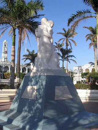
Tlacotalpan is a city in Tlacotalpan Municipality in the Mexican state of Veracruz, declared a World Heritage Site by UNESCO in 1998 primarily for its architecture and colonial-era layout. The town was established in 1550 on what was originally an island in the Papaloapan River. From the colonial era to the 20th century, it was an important port, one of few interior river ports in Latin America. However, with the construction of the railroad, Tlacotalpan's importance faded. Starting in the latter 20th century, efforts to conserve the city's Spanish/Caribbean architecture and layout began, culminating in World Heritage status. Today, its main economic support is fishing and tourism, especially to the annual feast in honor of Our Lady of Candlemas.

<span class="mw-page-title-main">Papaloapan River</span> River in Veracruz, Mexico

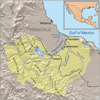
The Papaloapan River is one of the main rivers of the Mexican state of Veracruz. Its name comes from the Nahuatl papaloapan meaning "river of the butterflies".

Cosamaloapan is a city located in the plains of the Sotavento zone in the central zone of the State of Veracruz, about 240 km from state capital Xalapa. It has a surface of 323.26 km2. It is located at 18°22′N95°48′W.

<span class="mw-page-title-main">Alvarado, Veracruz</span> City in Veracruz, Mexico

Alvarado is a city in the Mexican state of Veracruz. The city also serves as the municipal seat for the surrounding municipality of the same name. It is located 64 km (40 mi) from the city of Veracruz, Veracruz, on Federal Highways 180 and 125. Alvarado is bordered by Boca del Río, Tlalixcoyan, Medellín, Ignacio de la Llave, Ciudad Lerdo de Tejada, Tlacotalpan and Acula. It is 10 m (33 ft) above sea level. It lies in the so-called "Region Papaloapan" bordered on the south by the municipalities of Acula, Tlacotalpan and Lerdo de Tejada, on the east by the Gulf of Mexico and on the west by Ignacio de la Llave.

<span class="mw-page-title-main">Otatitlán</span> Town and municipality in Veracruz, Mexico

Otatitlán is a town and municipality in the Mexican state of Veracruz, in the south of the state along the border with the state of Oaxaca. The town is best known for its large black image of a crucified Christ, one of three notable images of this type. Most of the population in Otatitlán is poor and the area is dedicated to agriculture, especially sugar cane and bananas.

<span class="mw-page-title-main">San Juan Bautista Tuxtepec</span> Municipality and city in Oaxaca, Mexico

San Juan Bautista Tuxtepec, or simply referred to as Tuxtepec, is the head of the municipality by the same name and is the second most populous city of the Mexican state of Oaxaca. It is part of the Tuxtepec District of the Papaloapan Region. As of the 2020 census, the city is home to a population of 103,609 and 159,452 in the municipality, though census data are often under reported for various reasons.

El Jícaro is a small town in the municipality of Tierra Blanca, in the Mexican state of Veracruz. It stands in the Río Papaloapan basin, at the 83rd kilometer of the Veracruz–Tierra Blanca railroad.

<span class="mw-page-title-main">Santiago Tuxtla</span> City and municipality in Veracruz, Mexico

Santiago Tuxtla is a small city and municipality in the Los Tuxtlas region of southern Veracruz, Mexico. The area was originally part of lands granted to Hernán Cortés by the Spanish Crown in 1531. The city was founded in 1525, but it did not gain municipal status until 1932. Today, the municipality is poor and agricultural, but is home to several unique traditions such as the Santiago Tuxtla Fair and the Acarreo de Niño Dios, when images of the Child Jesus are carried in procession several times during the Christmas season. It is also home to the Museo Regional Tuxteco which houses much of the area's Olmec artifacts, including a number of colossal heads and other monumental stone works. The city's main plaza hosts the largest Olmec colossal head in Mexico, thus making it famous.

Alvarado is one of the 212 municipalities of the Mexican state of Veracruz. The municipality is part of the state's Papaloapan Region and its municipal seat is established at the homonymous city of Alvarado.

Lerdo de Tejada is a municipality in the Mexican state of Veracruz, located 207 kilometres (129 mi) southeast of the state capital Xalapa. It is named after Sebastián Lerdo de Tejada, the 27th President of Mexico.

Ixmatlahuacan is a municipality in the Mexican state of Veracruz. It is in south zone of Veracruz, about 175 km from the state capital Xalapa. It has an area of 335.59 km2. It is located at 18°27′N95°50′W. Ixmatlahuacan is delimited to the northeast by Acula, to the east by Amatitlán, to the south by Cosamaloapan, to the west by Tierra Blanca, and to the north by Ignacio de la Llave.

<span class="mw-page-title-main">Loma Bonita</span> Municipality and town in Oaxaca, Mexico

Loma Bonita is a town and municipality in Oaxaca, Mexico. It is part of the Tuxtepec District of the Papaloapan Region. As of 2020, the municipality had a population of 40,943.

San Juan Bautista Valle Nacional is a town and municipality in Oaxaca in south-western Mexico. The municipality covers an area of 394.23 km² within the Sierra Juárez mountains. It is part of the Tuxtepec District of the Papaloapan Region. The town lies on the north bank of the Valle Nacional River, a tributary of the Papaloapan River.

<span class="mw-page-title-main">Tezonapa</span> Municipality in Veracruz, Mexico

Tezonapa is a municipality located in the high mountain region in the State of Veracruz, Mexico, about 219 km from state capital Xalapa. It covers an area of 351 square kilometres (136 sq mi).

Tlacojalpan is a municipality located in the south zone in the State of Veracruz, Mexico, about 175 km (109 mi) from state capital Xalapa. It has a surface of 91.30 km2. It is located at 18°14′N95°57′W. The name comes from the language Náhuatl, Tlahco-xal-pan; that means “In the half of the sandbank".

The Cerro de Oro Dam, also called the Miguel de la Madrid Hurtado Dam, is on the Santo Domingo River in the San Juan Bautista Tuxtepec municipality of the Papaloapan Region of Oaxaca state in southern Mexico. The dam operates in conjunction with the Miguel Alemán Dam, located on the Tonto River to control floods in the Papaloapan basin in Veracruz state. Construction began in 1973 and the dam was completed in May 1989. About 26,000 people were displaced by the project. Water quality in the reservoir is poor and deteriorating, affecting fish catches.

<span class="mw-page-title-main">Santo Domingo River (Oaxaca)</span> River in Oaxaca, Mexico

The Santo Domingo River in Oaxaca state, Mexico is one of the main tributaries of the Papaloapan River. It is formed by the confluence of the Salado and Grande rivers, which drain the dry Tehuacán and Cuicatlán valleys west of the Sierra Madre de Oaxaca. The Santo Domingo river flows east through the Sierra Madre, dividing the Sierra Zongolica sub-range to the north from the Sierra Juárez to the south. It joins with the Valle Nacional River above San Juan Bautista Tuxtepec to form the Papaloapan.

<span class="mw-page-title-main">Papaloapan Region</span> Region in Oaxaca, Mexico

The Cuenca del Papaloapan Region is in the north of the state of Oaxaca, Mexico where the foothills of the Sierra Madre de Oaxaca meet the coastal plain of Veracruz. The principal city is San Juan Bautista Tuxtepec, the second largest in Oaxaca state.

The current municipality of Ignacio de la Llave, previously known as San Cristobal de la Llave, is placed in the popularly known region of La Mixtequilla, which is located in the western limit of the Papaloapan river, going through the Blanco, Limón and Las Pozas rivers. The climate of the region varie between hot-humid and tropical-humid, with frequent summer rains between July and September. The average temperature is from 64 and 72 °F, with a maximum registered in the high 70s °F (24-26°C) and the lowest in the high 40 °F (7-9°C). Ignacio de la Llave is neighbor and has deep political, social and trading relationships with: Alvarado, Acula, Ixmatlahuacan, Tlalixcoyan and Tierra Blanca.

References