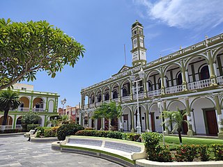
The municipality of Coatepec is located in the central region of the Mexican state of Veracruz. Its north latitude is 19° 27′, west longitude is 96° 58′, altitude of 1,200.00 m (3,937.01 ft), and surface of 202.4 km2 (78.1 sq mi). It represents the 0.338% of the current state. The municipal seat and largest community of the municipality is also called Coatepec. The Mexican census of 2020 reported a population of 55,720 in the city, while the municipality had 93,911 inhabitants. The municipality also includes many smaller communities within its boundaries. The largest of these are Tuzamapan,, Pacho Viejo, and Mahuixtlán.

Culiacán, officially Culiacán Rosales, is a city in northwestern Mexico, the capital and largest city of both Culiacán Municipality and the state of Sinaloa. The city was founded on 29 September 1531 by the Spanish conquerors Lázaro de Cebreros and Nuño Beltrán de Guzmán under the name "Villa de San Miguel", referring to its patron saint, Michael the Archangel.
Cotaxtla is a town and municipality in the Mexican state of Veracruz. It is located 45 km from the city of Veracruz on Federal Highway 180.

Las Vigas de Ramírez is a city in the Mexican state of Veracruz. It serves as the municipal seat for the surrounding municipality of the same name. The city was established by decree on 23 November 1523, named after the teacher Rafael Ramírez Castañeda (1884–1959).

Acajete Municipality is a municipality located in the central zone in the Mexican state of Veracruz, about 20 km from state capital Xalapa. It has a surface of 90.48 km2. It is located at 19°58′N97°00′W. In the middle of 1586 this village was formed, on one of the adjoining old men of Tlacolulan's dominion. The decree N ° 64 of November 3, 1893, extinguished the municipality of La Hoya, annexing its territory to San Salvador Acajete. On November 5, 1932, the municipal head-board San Salvador Acajete changes the name to Acajete.
Ixhuacán, or Ixhuacán de los Reyes, is a city in the Mexican state of Veracruz. It is located approximately 36 km (22 mi) from Xalapa Enríquez; Federal Highway 123 runs through it. It is bordered by Teocelo, Xico and Coatepec. Coffee is the chief product of Ixhuacán de los Reyes.
Emiliano Zapata is a city in the west-central part of the Mexican state of Morelos. It stands at 18°52′N99°09′W. The city serves as the county seat for the surrounding municipality of the same name. The municipality is the sixth largest in the state of Morelos, with a 2020 census population of 107,053 inhabitants, and has it an area of 64.983 km2. The city of Emiliano Zapata had 64,084 inhabitants in 2020. The city was previously known as both San Francisco Zacualpan and San Vicente Zacualpan. It was renamed in honor of Mexican Revolutionary Emiliano Zapata.
Tlaltizapán de Zapata is a city in the Mexican state of Morelos. It stands at 18°4′N99°07′W.
Santiago Jamiltepec is a town, and the seat of surrounding municipality of the same name, in the Mexican state of Oaxaca. It is located in the Jamiltepec District in the west of the Costa Chica Region, 30 km east of Pinotepa Nacional on Federal Highway 200, and 460 km southwest of state capital Oaxaca de Juárez.

Alvarado is a municipality in the Mexican state of Veracruz. The municipality is part of the state's Papaloapan Region and its municipal seat is established at the homonymous city of Alvarado.

Actopan Municipality is a municipality located in the montane central zone in the Mexican state of Veracruz, about 50 km from state capital Xalapa. It has a surface of 859.5 km2. It is located at 19°30′N96°37′W. Actopan, the municipal head-board is a small city, located closely of the capital of the state; for its nature, the extraordinary richness of its lands and the determination of its population has placed to this region as one of the most important zones of production of Mango of the State.

Apazapan is a municipality in the Mexican state of Veracruz. It is located about 65 km from state capital Xalapa. It has a surface of 65.80 km2. It is located at 19°19′N96°43′W. Apazapan was a population totonac in the days of the Spanish conquest that preserved the indigenous language up to the 19th century and there was one of the points marked in the Codex Dehesa, when the Nonoalcos de Zongolíca, crossed Cocolapa, Coscomatepec, Tepeyehualco, Chiconquiaco and for Apazapan they returned to Zongolíca. During the 16th century, it belonged to the marquisate of Paxaca's Valley started to Hernán Cortés.
Cosautlán is a municipality in the Mexican state of Veracruz. It is located in the montane central zone of the state, about 23.5 km from Xalapa, the state capital. It has a surface of 72.38 km2. It is located at 19°20′N96°59′W. The town has 2224 men and 2393 women.

Jalcomulco is a municipality in the Mexican state of Veracruz, founded in 1825.
Medellín Municipality is a municipality in the Mexican state of Veracruz. The municipal seat is the town of Medellín.

Miahuatlán Municipality is a municipality in the Mexican state of Veracruz.

Banderilla is a municipality in the Mexican state of Veracruz. It is located about 9 km from the state capital, Xalapa. It has a surface area of 22.21 km2. It is located at 19°35′N96°56′W.

Peñamiller Municipality is a municipality in the Mexican state of Querétaro in central Mexico.
Emiliano Zapata is a municipality in the Mexican state of Chiapas, located approximately 33 kilometres (21 mi) southeast of the state capital of Tuxtla Gutiérrez.
Dos Ríos is a locality in the municipality of Emiliano Zapata, Veracruz, Mexico. It is located on the southeastern part of the country, about 77 kilometers northwest of the city of Veracruz. As of the year 2020, it had a total population of 1,698.


