
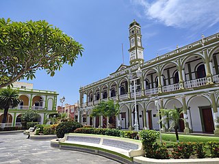
Córdoba, known officially as Heroica Córdoba, is a city and the seat of the municipality of the same name in the Mexican state of Veracruz. It was founded in 1618.

Emiliano Zapata is a municipality in the Mexican state of Veracruz. It is located 2 km from Jalapa-Enríquez on Federal Highways 180 and 190. The municipality is named for the hero of the Mexican Revolution, Emiliano Zapata.

Acajete Municipality is a municipality located in the central zone in the Mexican state of Veracruz, about 20 km from state capital Xalapa. It has a surface of 90.48 km2. It is located at 19°58′N97°00′W. In the middle of 1586 this village was formed, on one of the adjoining old men of Tlacolulan's dominion. The decree N ° 64 of November 3, 1893, extinguished the municipality of La Hoya, annexing its territory to San Salvador Acajete. On November 5, 1932, the municipal head-board San Salvador Acajete changes the name to Acajete.
Ixhuacán, or Ixhuacán de los Reyes, is a city in the Mexican state of Veracruz. It is located approximately 36 km (22 mi) from Xalapa Enríquez; Federal Highway 123 runs through it. It is bordered by Teocelo, Xico and Coatepec. Coffee is the chief product of Ixhuacán de los Reyes.
Alvarado is a municipality in the Mexican state of Veracruz. The municipality is part of the state's Papaloapan Region and its municipal seat is established at the homonymous city of Alvarado.

Actopan Municipality is a municipality located in the montane central zone in the Mexican state of Veracruz, about 50 km from state capital Xalapa. It has a surface of 859.5 km2. It is located at 19°30′N96°37′W. Actopan, the municipal head-board is a small city, located closely of the capital of the state; for its nature, the extraordinary richness of its lands and the determination of its population has placed to this region as one of the most important zones of production of Mango of the State.
Altotonga Municipality is a municipality in the Mexican state of Veracruz. It is located about 80 km northwest of the state capital Xalapa. It has an area of 328.7 km2 It is located at 19°46′N97°15′W.

Apazapan is a municipality in the Mexican state of Veracruz. It is located about 65 km from state capital Xalapa. It has a surface of 65.80 km2. It is located at 19°19′N96°43′W. Apazapan was a population totonac in the days of the Spanish conquest that preserved the indigenous language up to the 19th century and there was one of the points marked in the Codex Dehesa, when the Nonoalcos de Zongolíca, crossed Cocolapa, Coscomatepec, Tepeyehualco, Chiconquiaco and for Apazapan they returned to Zongolíca. During the 16th century, it belonged to the marquisate of Paxaca's Valley started to Hernán Cortés.

Ayahualulco is a municipality in the Mexican state of Veracruz.

Chiconquiaco is a municipality in the Mexican state of Veracruz. It is located in the Sierra de Chiconquiaco in the middle of the State of Veracruz. It has a surface of 68.27 km2. It is located at 19°45′N96°49′W.

Coacoatzintla in a municipality in the Mexican state of Veracruz. It is located in the mountainous central zone of the state, about 11.5 km from the state capital Xalapa. It has a surface of 43.9 km2. It is located at 19°39′N96°56′W.

Coatzintla is a municipality in the Mexican state of Veracruz. It is located in the north of state, about 120 kilometres (75 mi) from the state capital Xalapa. It covers an area of 235.25 square kilometres (90.83 sq mi). It is located at 20°29′N97°28′W. As 2020 the municipality had a population of 55,016, with 34,039 in the municipal seat. Other localities includes Geovillas del Real, Manuel María Contreras, Palma Sola and Corralillos.
Cosautlán is a municipality in the Mexican state of Veracruz. It is located in the montane central zone of the state, about 23.5 km from Xalapa, the state capital. It has a surface of 72.38 km2. It is located at 19°20′N96°59′W. The town has 2224 men and 2393 women.
Landero y Coss is a municipality in the Mexican state of Veracruz.
Medellín Municipality is a municipality in the Mexican state of Veracruz. The municipal seat is the town of Medellín.

Miahuatlán Municipality is a municipality in the Mexican state of Veracruz.
Rafael Delgado, former known as San Juan del Rio, is a municipality located in the mountainous central zone of the Mexican state of Veracruz, about 140 km from the state capital Xalapa. It has an area of 39.48 square kilometres (15.24 sq mi).

Tezonapa is a municipality located in the high mountain region in the Mexican state of Veracruz, about 219 km from the state capital Xalapa. It covers an area of 351 square kilometres (136 sq mi). The law number 93 of December 22, 1960 San Agustín created Tezonapa's municipality with the congregations of the Josefinas, Prison, Tezonapa, Palmarito, etc.

Banderilla is a municipality in the Mexican state of Veracruz. It is located about 9 km from the state capital, Xalapa. It has a surface area of 22.21 km2. It is located at 19°35′N96°56′W.
Las Minas is a municipality in the Mexican state of Veracruz, located 28 kilometres (17 mi) northeast of the state capital Xalapa.


