
Coatzacoalcos Municipality is a municipality in the Mexican state of Veracruz. [1]
Coatzacoalcos Municipality is a municipality in the Mexican state of Veracruz. [1]
Las Choapas is a city and its surrounding municipality in the southeastern extremes of the Mexican state of Veracruz. It is bordered by the municipalities of Uxpanapa, Minatitlán, Moloacán, and Agua Dulce in Veracruz, Huimanguillo in Tabasco, Cintalapa and Tecpatán in Chiapas, and Santa María Chimalapa in Oaxaca. Its major products are cattle breeding, corn, oil, fruit, sugar, and rubber. In the past it had a rice miller. It is one of the largest municipalities in Veracruz, with an area of 2,851.2 km². At the 2005 census the city had a population of 40,773 inhabitants, while the municipality had a population of 70,092. It is a very hot place, as temperature reaches up to 40 degrees Celsius. It has had some tornadoes in the past. It is connected to the communities of Raudales-Ocozocoautla in Chiapas through the Chiapas bridge.

Semerovo is a village and municipality in the Nové Zámky District in the Nitra Region of south-west Slovakia.
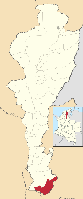
San Alberto is a town and municipality in the Colombian Department of Cesar.

Protein transport protein Sec16B also known as regucalcin gene promoter region-related protein p117 (RGPR-p117) and leucine zipper transcription regulator 2 (LZTR2) is a protein that in humans is encoded by the SEC16B gene.
Agua Dulce Municipality is a municipality in the Mexican state of Veracruz. It is located about 330 kilometres (210 mi) southeast from the state capital Xalapa. It has an area of 372.03 square kilometres (143.64 sq mi).
Chinameca Municipality is a municipality in the Mexican state of Veracruz.
Cosoleacaque is a municipality in the Mexican state of Veracruz. It is located in the south-east zone of the state, about 300 km (190 mi) from the state capital Xalapa. It has a surface of 234.42 km2 (90.51 sq mi). It is located at 18°00′N94°38′W.
Mecayapan is a municipality and city in the Mexican state of Veracruz. It is located in the south-east zone of the State, about 428 km from the state capital Xalapa. It has a surface of 523.96 km2. It is located at 18°13′N94°50′W.
Nanchital is a municipality in the Mexican state of Veracruz. It is about 438 km from Xalapa, the state capital. It has an area of 63.99 km2. It is at 18°04′N94°25′W.
Oluta is a municipality in the Mexican state of Veracruz. It is located in the south-east zone of the state, about 371 km from the state capital Xalapa. It has a surface of 90.48 km2. It is located at 17°56′N94°54′W.
Oteapan is a municipality in the Mexican state of Veracruz. It is in the south-east zone of the state, about 394 km from the state capital Xalapa. It has an area of 27.97 km2. It is located at 18°00′N94°40′W.
Pajapan is a municipality and city in the Mexican state of Veracruz. It is located in the south zone of the state of Veracruz, about 496 km (308 mi) from the state capital of Xalapa. It has a surface of 305.98 km2 (118.14 sq mi), and is located at 18°16′N94°41′W.
Soconusco Municipality is a municipality in the Mexican state of Veracruz, about 275 kilometres (171 mi) from the state capital Xalapa. It has an area of 94.59 square kilometres (36.52 sq mi). It is located at 17°58′N94°53′W.
Soteapan is a municipality and city located in the south-central zone of the Mexican state of Veracruz, about 260 km from state capital Xalapa. As of 2000, the municipality counted 27,487 inhabitants within 528.07 km², including about 10,000 in the main city area of Soteapan.
Tatahuicapan de Juárez or Tatahuicapan is a municipality located in the south-east of the Mexican state of Veracruz. It was created in 1997 with an area of 208.06 km2.
Šaprance is a village in the municipality of Trgovište, in southeastern Serbia. According to the 2002 census, the village has a population of 83 people.

Popadić is a village situated in Mionica municipality in Serbia.

Quarto dei Mille is a residential district in the east of Genoa, Italy, overlooking the sea. Located between the Sturla and Quinto al Mare districts, it was originally called Quarto al Mare.

Stubel is a village in Montana Municipality, Montana Province, northwestern Bulgaria.
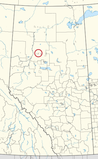
Woodland Cree 227 is an Indian reserve of the Woodland Cree First Nation in Alberta, located within Northern Sunrise County. It is 60 kilometres northeast of Peace River.
18°07′30″N94°23′21″W / 18.1250°N 94.3892°W
| | This article about a location in the Mexican state of Veracruz is a stub. You can help Wikipedia by expanding it. |