Catemaco (municipality)

Last updated
Catemaco
Catemaco Shore.jpg
City of Catemaco from the lake
Mexico States blank map.svg
Red pog.svg
Catemaco
Location in Mexico
Coordinates: 18°25′0″N95°07′0″W / 18.41667°N 95.11667°W / 18.41667; -95.11667
CountryFlag of Mexico.svg  Mexico
State Veracruz
Municipal seat Catemaco
Government
   Municipal President Julio César Ortega Serrano [1]
Area
  Total710.67 km2 (274.39 sq mi)
Elevation
340 m (1,120 ft)
Population
 (2010)
  Total48,593
  Density68/km2 (180/sq mi)
  Municipal seat
22,965
Website www.catemaco.gob.mx

Catemaco Municipality is a municipality in the Mexican state of Veracruz. It is located in the state's Los Tuxtlas region. The municipal seat is the city of Catemaco.

Contents

In the 2005 INEGI Census, the municipality reported a total population of 46,702, of whom 22,965 lived in the municipal seat. [2] Ethnic composition is primarily of mestizo origins. Indigenous language speakers number less than 500.

The municipality of Catemaco covers a total surface area of 710.67 km² along the Gulf of Mexico between the foothills of Volcano San Martín Tuxtla and the Sierra Santa Marta, and incorporate Laguna Catemaco and Laguna Sontecomapan plus a large part of the Los Tuxtlas Biosphere Reserve. Catemaco borders the municipalities of San Andrés Tuxtla to the west, Hueyapan de Ocampo and Soteapan to the south and Tatahuicapan de Juárez and Mecayapan to the east.

Economically Catemaco depends on a mix of tourism, cattle ranching, fishery and agriculture. Statistically the municipality ranks as one of the poorer ones in Veracruz.

Settlements in the municipality

The municipality

Section of the Barra de Sontecomapan on the Gulf of Mexico BarraSontecomapan20.JPG
Section of the Barra de Sontecomapan on the Gulf of Mexico

The city of Catemaco is the local government for 258 communities, which cover a territory of 659.2km2. [3] The municipality borders those of Mecayapan, Soteapan, Hueyapan de Ocampo and San Andrés Tuxtla, extending to the Gulf of Mexico in the north. The municipal government consists of a municipal president, a syndic and four representatives called regidors. [4]

The municipality is rural with a population density of 73.7 people per km2, and only the seat considered to be urban. [3] There a small community (297) of indigenous language speakers, mostly of Popoluca. [3] Outside the seat, the main communities are Sontecomapan (pop. 2,413), La Victoria (1,842), Zapoapan de Cabañas (1,382) and San Juan Seco de Valencia (1,237). [3]

The municipality has 166 schools that mostly serve students from the preschool to high school/vocational level with some adult and special education. There are fifteen libraries but a 17.1% illiteracy rate. [3]

The municipality has 204 km of major roadways, mostly state-maintained local highways. [3] The most important road is Federal Highway 180, which connects the municipality primarily to San Andrés Tuxtla. There are no rail lines. [4] [5]

Geography

Looking towards Lake Catemaco from the Xococapan Tourist Ranch Xococapan10.JPG
Looking towards Lake Catemaco from the Xococapan Tourist Ranch
Lake island filled with herons Lake Catemaco23.JPG
Lake island filled with herons
Spider monkey on island in Lake Catemaco Lake Catemaco40.JPG
Spider monkey on island in Lake Catemaco
A hut on the lake Catemaco Hut.jpg
A hut on the lake

The municipality is in the Los Tuxtlas mountain region in the south of Veracruz, a rugged area of recent volcanic origin. [4] [6] It is in a valley between the San Martín Volcano and the Santa Marta mountain ranges, extending from Lake Catemaco to the Gulf of Mexico shore, with an average altitude of 340 meters above sea level. [4] [7]

Flora and fauna

Most of the wild vegetation has been destroyed, with 391.6km2 used as pasture for animals, 50.8 km used for agriculture and 39.4km2 with secondary vegetation. Only 84.8km2 remains as rainforest and 81.2km2 is covered by water. [3] The soil is poor in nutrients and highly susceptible to erosion. [4] The remaining natural vegetation is high tropical perennial rainforest, giving way to wetland vegetation and mangroves near and on the Gulf coast. [4] [5] Native tree species include cedar, royal palm, palo de agua, ojite ( Brosimum alicastrum ), ojueta, marayo and rabo lagarto ( Equisetum arvense ). The Nanciyaga Ecological Reserve preserve most of what is left of the rainforest that enveloped Lake Catemaco. [6] Wildlife include small mammals such as squirrels, armadillos, rabbits, weasels and raccoons. [4] Many bird species inhabit the lake area including herons, owls, cardinals and more. Numbers are highest in December with the arrival of migratory species. [4] [6] Spider monkeys were extinct but have been reintroduced in the Lake Catemaco area. [8]

Climate

For most of the year, the climate is warm and humid. The average temperature ranges from 20 to 26C, with the coolest months from November to January and the warmest in the summer. [5] It rains all year because of warm humid winds from the Gulf of Mexico, but annual totals vary from 1900mm to 4600mm. [3] [6] The quantity of rainfall also varies by season, with a relatively dry season from March to June, when totals are half that of the rest of the year. Winds are predominantly from the north. From February to October, most winds are from the northeast, which are warmer. From November to January cooler winds from the north dominate due to cold fronts from the north called “nortes.” [5] [6]

Most of the municipality’s surface water is found in Lake Catemaco and the Sontecomapan Lagoon. The area is filled with rivers and streams including the San Juan Michapan, Comoapan, San Andrés and Río Grande. Because of the area’s relative ruggedness, waterfalls can be found, such as the Tepepa Falls on the San Andrés River. [4]

Hydrography

The most important body of water in the municipality is Lake Catemaco. The lake basin was formed by volcanic eruptions of the Santa Martha and San Martín Volcanos. The lake is elliptical, with a maximum length of eleven km and a maximum width of eight km. [4] [5] It contains 553 million cubic meters of water and covers and area of 73km2, but is shallow, with an average depth of eight meters. The deepest part is twenty two meters, located between the city and Agaltepec Island. [5] Various rivers and streams empty into the lake including Río Grande, Yohualtajapan and Cuetzalapan. The Rio Grande, also known as the San Andrés River, empties the lake and forms the Eyipantla Falls on its way to the Gulf of Mexico. [4] [5]

The lake and its twelve islands have been designation as a federal natural park. [7] The largest of these islands is Agaltepec, 750 meters long and 150 at its widest, covering 8.5 hectares. This name is from Pipil and Nahuatl and means “stone canoe” or “canoe hill.” It is also called Crocodile or Dragon Island in reference to is shape which resembles the animal when seen from certain perspectives. Its vegetation remains intact with over 1,600 trees of 63 species. In 1988 and 1989, two groups of howler monkeys, which are in danger of extinction, were brought to the Agaltepec Island as an attempt to preserve the species. Since then the animals have multiplied with over 100 and their cries can be heard in the nearby city. The island is federal property and is maintained by the Universidad Veracruzana. [5] There is also an archeological site on the island. [7] Tanaxpillo, better known as the “Island of the Monkeys.” This name and fame comes from a colony of stump-tailed macaques that live there, introduced as part of a research project in the 1970s. They are maintained by the university although they are also fed by local boat operators. [4] [5] One other popular island for visitors is the Heron Island (Isla de las Garzas), a sanctuary of the species, which cover the trees and have painted them white from their excrement. [4] [7]

The other major body of water within the municipality is the Sontecomapan Lagoon. It is a large, shallow estuary which opens to the sea, covering 900 hectares in a very irregular shape. Its average depth is only two meters with the deepest part at five meters. [5] The lagoon is fed by various rivers and streams with the salinity of the water increasing the closer one is to the Gulf of Mexico. It is mostly separated from the Gulf by the Barra de Sontecomapan, a stretch of beach and offshore reefs. [4] [7] Canals also stretch from the main body of water, and both these canals and the edges of the lagoon contain mangroves. [4] [7] The town of Sontecomapan, which the lake is named after, has docks for fishing and tours to see the area’s vegetation, especially its mangroves. [4]

Lake Nixtamalpan is in a crater filled from underground. Its depth is unknown but estimated at fifty meters, and covers and area of about twenty hectares. [5]

The municipality has a coastline on the Gulf of Mexico. The most visited beaches here are Peña Hermosa in Tatahuicapan de Juárez, La Perla del Golfo in Mecayapan and Playa Escondida, most popular with foreign tourists. [4] [7]

Socioeconomics

Man fishing on Lake Catemaco Lake Catemaco27.JPG
Man fishing on Lake Catemaco
Man with mud facial drinking mineral water from leaf cup at Nanciyaga Ecological Reserve Nanciyaga45.JPG
Man with mud facial drinking mineral water from leaf cup at Nanciyaga Ecological Reserve

The municipality is classified as having a medium level of socioeconomic marginalization, with 64.5% living in poverty and 13.1% living in extreme poverty. 26.9% are employed in agriculture, fishing and forestry, 15.5% in manufacturing (mostly handcrafts) and 56.9% in commerce and tourism. [3] However, the municipality’s main income is from ranching, fishing and agriculture. [4]

The most widespread activity is ranching, mostly raising cattle, followed by pigs and domestic fowl. [3] [5] Next is fishing. Lake Catemaco is one of the most productive in Mexico, but large net fishing is prohibited in order avoid overfishing. However, over 2,000 fishermen earn a subsistence living capturing about 2,000 tons each year. Main catches include tilapia (an introduced species), a sardine called topote and a fresh water snail called tegogolo. [5] The most important crops are corn, followed by coffee and green chili peppers, [3] but beans, rice, watermelons, oranges, mangos and coconuts are also grown. [5] [6]

The local gastronomy is characterized by its ranching and fishing activities (both fresh and salt water) . [8] Common ingredients include tegogolos, a fresh water snail said to be an aphrodisiac, [4] [6] freshwater eels, tochogobi (a type of mojarra) and pork, especially a preparation called “carne de chango” because it takes like monkey meat. [4] [6] [9]

Hotel del Brujo in Catemaco Hotel del Brujo Catemaco.JPG
Hotel del Brujo in Catemaco

The area holds deposits of gold, silver, zinc and other materials, [4] but there is no mining and no major industry. [5] Handcrafts are made, mostly guitars called jarana jarochas (often decorated with snail and seashells) and decorative items for the tourist trade. [4]

The most important commercial activity is tourism, mostly centered in the city of Catemaco. The area attracts mostly Mexican visitors, with the busiest times being traditional vacation periods such as Holy Week, some parts of summer and long weekends. [5] Most come to see the lake, including boat tours to the various islands, and visit the sorcerers. [6] The area has also attracted the film industry, with films such as Medicine Man with Sean Connery and Apocalypto, filmed by Mel Gibson . [10]

Ecological tourism has grown in the municipality, allowing rural communities such as Ejido Lopez Mateos and Ejido Miguel Hidalgo to offer cabins and access to attractions such as rainforest, rivers and waterfalls, such as Cola de Caballo and Poza Reina. There are also archeological sites such as Las Margaritas and a pyramid on El Cerrito just outside Catemaco city. [7] [8]

The most popular attraction of this type is the Nanciyaga Ecologial Reserve, a private tourist attraction which offers tours, mud facials, cabins, ritual cleansings, temazcals, a dock on Lake Catemaco and a mineral spring. [4] [5] [11] The site cover four hectares just outside the city of Catemaco and was created in 1983. The water from the mineral spring is drinkable and made available to visitors using cups made from large green leaves. [7]

Related Research Articles

<span class="mw-page-title-main">Veracruz</span> State of Mexico

Veracruz, formally Veracruz de Ignacio de la Llave, officially the Estado Libre y Soberano de Veracruz de Ignacio de la Llave, is one of the 31 states which, along with Mexico City, comprise the 32 Federal Entities of Mexico. Located in eastern Mexico, Veracruz is bordered by seven states, which are Tamaulipas, San Luis Potosí, Hidalgo, Puebla, Oaxaca, Chiapas, and Tabasco. Veracruz is divided into 212 municipalities, and its capital city is Xalapa-Enríquez.

<span class="mw-page-title-main">Tabasco</span> State of Mexico

Tabasco, officially the Free and Sovereign State of Tabasco, is one of the 32 Federal Entities of Mexico. It is divided into 17 municipalities and its capital city is Villahermosa.

<span class="mw-page-title-main">Tuxtla Gutiérrez</span> City & municipality in Chiapas, Mexico

Tuxtla Gutiérrez, or Tuxtla,(Spanish:[ˈtuɣstlaɣuˈtjeres], Nahuatl:[ˈtuʃt͡ɬa]) is the capital and the largest city of the Mexican southeastern state of Chiapas. It is the seat of the municipality of the same name, the most developed and populated in the state. A busy government, commercial and services-oriented city, Tuxtla had one of the fastest-growing rates in Mexico in the last 40 years. Unlike many other areas in Chiapas, it is not a major tourist attraction, but a transportation hub for tourists coming into the state, with a large airport and a bus terminal.

<span class="mw-page-title-main">Catemaco</span> City and municipal seat in Veracruz, Mexico

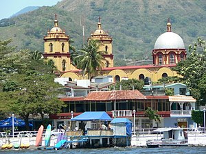
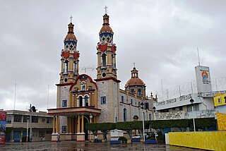
Catemaco is a city in Catemaco Municipality located in the south of the Mexican state of Veracruz. The city is located on Lake Catemaco, with the municipality stretching north to the Gulf of Mexico. Catemaco is a tourist destination, with its main attractions being the lake, remnants of the region's rainforest and a tradition of sorcery/witchcraft that has its roots in the pre-colonial period and is mostly practiced by men. This tradition is well-known in Mexico and attracts clients from various walks of life, including businessmen and national-level politicians. Catemaco holds an annual event in March dedicated to sorcery, which can draw up to 5,000 visitors.

<span class="mw-page-title-main">Laguna Catemaco</span> Freshwater lake near Catemaco, Veracruz, Mexico

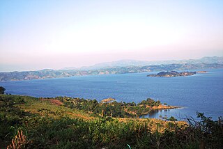
Laguna Catemaco is a freshwater lake located at the center of the Sierra de Los Tuxtlas in south central Veracruz near the city of Catemaco, in east central Mexico.

<span class="mw-page-title-main">Los Tuxtlas</span> Mexican state

Los Tuxtlas is a region in the south of the Mexican state of Veracruz.

<span class="mw-page-title-main">Sumidero Canyon</span> National park in Mexico

Sumidero Canyon is a deep natural canyon located just north of the city of Chiapa de Corzo in the state of Chiapas, in southern Mexico. The canyon's creation began around the same time as the Grand Canyon in the U.S. state of Arizona, by a crack in the area's crust and subsequent erosion by the Grijalva River, which still runs through it. Sumidero Canyon has vertical walls which reach as high as 1,000 metres (3,300 ft), with the river turning up to 90 degrees during the 13-kilometre (8 mi) length of the narrow passage.

<span class="mw-page-title-main">Montepío</span> Village in Veracruz, Mexico

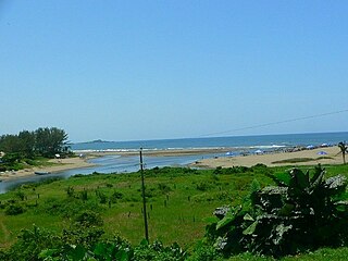
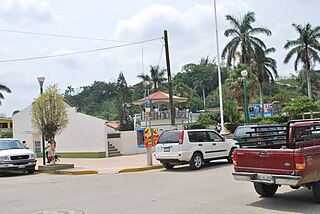
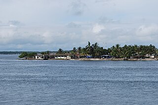
Montepío is a small village on the Gulf Coast of Mexico, within the San Andrés Tuxtla municipality, Veracruz, 1 hour away from the major tourist center of Catemaco.

<span class="mw-page-title-main">Santiago Tuxtla</span> City and municipality in Veracruz, Mexico

Santiago Tuxtla is a small city and municipality in the Mexican state of Veracruz. The area was originally part of lands granted to Hernán Cortés by the Spanish Crown in 1531. The city was founded in 1525, but it did not gain municipal status until 1932. Today, the municipality is poor and agricultural, but is home to several unique traditions such as the Santiago Tuxtla Fair and the Acarreo de Niño Dios, when images of the Child Jesus are carried in procession several times during the Christmas season. It is also home to the Museo Regional Tuxteco which houses much of the area's Olmec artifacts, including a number of colossal heads and other monumental stone works. The city's main plaza hosts the largest Olmec colossal head in Mexico, thus making it famous.

<span class="mw-page-title-main">San Andrés Tuxtla</span> City and municipality in Veracruz, Mexico

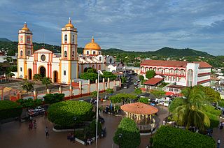
San Andrés Tuxtla is a city and municipality in the south of the Mexican state of Veracruz. The city is the largest in the Los Tuxtlas region. It was founded after an eruption of the San Martín Volcano pushed people into this valley during the early colonial period. Since the 19th century, the area has been the center of Mexico's production of fine tobacco, mostly used in the making of cigars.

Lerdo de Tejada is a municipality in the Mexican state of Veracruz, located 207 kilometres (129 mi) southeast of the state capital Xalapa. It is named after Sebastián Lerdo de Tejada, the 27th President of Mexico.

<span class="mw-page-title-main">Paraíso, Tabasco</span> Town & Municipality in Tabasco, Mexico

Paraíso is a town and municipality located in the north of the Mexican state of Tabasco, about 75 km due north of the state capital of Villahermosa on the Gulf of Mexico. Much of the area is traditionally dedicated to fishing and agriculture. Today, it is also an oil-producing area with the mostly oil-dedicated port of Dos Bocas. There is also some tourism connected to the area's beaches and natural attractions, and the area is promoted under the state's Cacao Route tourism program.

<span class="mw-page-title-main">Cazones de Herrera</span> Town and Municipality in Veracruz, Mexico

Cazones de Herrera, or Cazones, is a town and municipality located in the north of the Mexican state of Veracruz on the Gulf of Mexico. While it has tourist attractions along its shore, especially in the Barra de Cazones area, the municipality, including the seat, has a high level of socioeconomic marginalization. Most of the municipality's population works in agriculture.

Tatahuicapan de Juárez or Tatahuicapan is a municipality located in the south-east of the Mexican state of Veracruz. It was created in 1997 with an area of 208.06 km2.

<span class="mw-page-title-main">Hermosillo Municipality</span> Municipality in Sonora, Mexico

Hermosillo is a municipality in Sonora in north-western Mexico. The municipal seat is the city of Hermosillo.

<span class="mw-page-title-main">Malpaso Dam</span> Dam in Tecpatán, Chiapas

The Malpaso Dam, officially known as the Nezahualcóyotl Dam, is located in the Centro region of Chiapas, Mexico near the border with Tabasco and Veracruz. It was the first of several major dams built on the Grijalva River to generate hydroelectric energy and has the second largest reservoir in Mexico, after the Belisario Dominguez Dam. Construction of the dam occurred in the 1960s and flooded not only the riverbed but also hectares of rainforest and farmland, various towns and villages and archeological sites. These include the former town of Quechula, whose 16th century Dominican church will appear when water is at low levels, and the archeological site of San Isidro which contains one of only two known double Mesoamerican ball courts. Commissioning of the dam's 1,080 MW power station began in 1969 and ended in 1977. The reservoir and later construction of a federal highway has spurred ecotourism in the area.

<span class="mw-page-title-main">Sánchez Magallanes</span>

Sánchez Magallanes is a small fishing town and port located in the far northwest of the state of Tabasco, Mexico in the municipality of Cárdenas. It is named after a leader in the French Intervention in Mexico, Coronel Andrés Sánchez Magallanes. The town is located on small peninsula which is between the Gulf of Mexico and a lagoon called Del Carmen, which the port faces. Fishing is the main economic activity here, especially the production of oysters, although there is tourism and oil production as well. The last has been problematic for fishing and tourism due to pollution. The most serious environmental problem is the erosion of the area’s fragile beaches, especially the thin strips of land between the Gulf and the lagoons.

<span class="mw-page-title-main">Eyipantla Falls</span>

Eyipantla Falls is a waterfall located in the Los Tuxtlas region of southern Veracruz in Mexico. It is forty meters wide and fifty meters tall and is the largest and most important waterfall in the region.

References

  1. "Toma de protesta del alcalde electo de Catemaco". Diario Eyipantla (Eyipantla Newspaper) (in Spanish). 30 December 2017. Retrieved 1 January 2018.
  2. "Catemaco". Enciclopedia de los Municipios de México. Instituto Nacional para el Federalismo y el Desarrollo Municipal. 2005. Archived from the original on 2007-05-21. Retrieved 11 November 2008.
  3. 1 2 3 4 5 6 7 8 9 10 11 "Catemaco" (PDF). Sistema de Información Municipal, Cuadernillos Municipales, 2014. Secretaría de Finanzas y Planeación del Estado de Veracruz. Archived from the original (PDF) on May 4, 2014. Retrieved May 3, 2014.
  4. 1 2 3 4 5 6 7 8 9 10 11 12 13 14 15 16 17 18 19 20 21 22 23 "Catemaco". Enciclopedia de Los Municipios y Delegaciones de México Estado de Veracruz-Llave (in Spanish). Mexico: INAFED. Archived from the original on November 9, 2013. Retrieved May 3, 2014.
  5. 1 2 3 4 5 6 7 8 9 10 11 12 13 14 15 16 17 "Catemaco, Veracruz" (PDF). SEMAR. Retrieved May 3, 2014.
  6. 1 2 3 4 5 6 7 8 9 Edgar Anaya (August 12, 2001). "Catemaco: El embrujo de un lago". El Norte. p. 1.
  7. 1 2 3 4 5 6 7 8 9 Veracruz: Guía para descubrir los encantos del estado. Mexico City: Editorial Océano de México. 2010. pp. 73–74. ISBN   978-607-400-323-9.
  8. 1 2 3 Harry Mller (October 12, 2003). "Mexico Channel / Las cosas nuevas de Catemaco". Mural. Guadalajara. p. 9.
  9. Jim Budd (October 27, 2002). "Viajando Ligero/ El misterioso Catemaco". Reforma. Mexico City. p. 5.
  10. Cesar Huerta (December 22, 2005). "Deja Mel dinero en Catemaco". Reforma. Mexico City. p. 16.
  11. Alessandro Triacca (December 8, 2013). "Tradición prehispánica". Mural. Guadalajara. p. 7.