Tabasco, officially the Free and Sovereign State of Tabasco, is one of the 32 Federal Entities of Mexico. It is divided into 17 municipalities and its capital city is Villahermosa.

Atlatlahucan is a city in the Mexican state of Morelos. The name means Place of red or brown water, and today the water is stored in a type of cistern called a jagüey. To the north is the State of Mexico, south is Cuautla, east is Yecapixtla, and west are Tlayacapan and Yautepec. It stands at 18°56′N98°54′W, at a mean height of 1,656 metres above sea level. The municipality covers 71 km2.
Jantetelco, officially Jantetelco de Matamoros, is a city in the Mexican state of Morelos. . The city serves as the municipal seat for the surrounding municipality of the same name. The municipality reported 17,238 inhabitants in the year 2015 census.
Jonacatepec de Leondro Valle is a city in the Mexican state of Morelos. The city serves as the municipal seat for the surrounding municipality of the same name. The municipality reported 15,690 inhabitants in the year 2015 census.
Ocuituco is a town in the Mexican state of Morelos and the municipal head for the Municipality of Ocuituco which includes the towns of Ocuituco, Huejotengo, Huecahuaxco, Huepalcalco, Metepec, and Ocoxaltepec, as well as a number of settlements with fewer than 300 inhabitants. The name comes from Nahuatl Okuiltoco and means Where there are weevils. It is one of the 36 municipalities of the state of Morelos. To the north of Ocuitico is México State, southeast is Zacualpan, east is Tetela del Volcán, and southwest is Yecapixtla. It stands at 18°52′N98°46′W, at 1,920 meters above sea level. It is considered one of the municipalities of the "Los altos de Morelos".

Tetecala is a city in the Mexican state of Morelos.
Xochitepec is a municipio (municipality) of the state of Morelos, in central Mexico. Xochitepec is also the name of its principal township and seat of the municipal government. It is located approximately 13 km (8.1 mi) to the south of the capital of Morelos, Cuernavaca, on the southern outskirts of that city's greater metropolitan area.

Uxpanapa is a municipality in the southeastern part of the Mexican state of Veracruz, adjacent to the state of Oaxaca. It is bordered by the municipalities of Jesús Carranza, Hidalgotitlán, Minatitlán, and Las Choapas in Veracruz, as well as Santa María Chimalapa in Oaxaca. It has an area of 2,600 km².

Guanaceví is a town located in the northwest of the Mexican state of Durango. As of 2015, the town of Guanaceví had a population of 2,908. It serves as the municipal seat of the municipality of Guanaceví, which in the 2015 Census had a population of 9,851. It is filled with mines that contain many minerals such as gold, silver, and brass. It has many food traditions that includes sopes, enchiladas, chapaneco, tezhuino, queso, chiles rellenos, etc.
Churumuco is a municipality located in the southeastern part of the Mexican state of Michoacán. The municipality has an area of 1,119.44 square kilometres and is bordered to the north by the municipality of La Huacana, to the northeast by Turicato, to the south by the state of Guerrero, to the southwest by Huetamo, and to the west by Arteaga. The municipality had a population of 13,801 inhabitants according to the 2005 census.

Llera de Canales is a municipality located in the Mexican state of Tamaulipas. Also called Llera, the municipality has an area of 2,307 square kilometres (891 sq mi) and a 2010 population of 17,333. The population of the town of Llera is 4,148. Llera was founded December 25, 1748 and later renamed Llera de Canales.
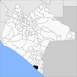
Villa Mazatán (Spanish pronunciation:[ˈβiʝamasaˈtan] is a municipality in the Mexican state of Chiapas in southern Mexico. It has an area of 386.6 km ² and is located in the southwestern Mexican state.
Guadalupe Victoria Municipality is a municipality in the Mexican state of Puebla. According to the National Statistics Institute (INEGI), it had a population of 15,041 inhabitants in the 2005 census. Its total area is 239.83 km². It is named after Guadalupe Victoria, the first president of Mexico.
Vicente Guerrero is a municipality in the Mexican state of Puebla. The capital of the commune is Santa María del Monte.
Paraíso is a town and municipality located in the north of the Mexican state of Tabasco, about 75 km due north of the state capital of Villahermosa on the Gulf of Mexico. Much of the area is traditionally dedicated to fishing and agriculture. Today, it is also an oil-producing area with the mostly oil-dedicated port of Dos Bocas. There is also some tourism connected to the area's beaches and natural attractions, and the area is promoted under the state's Cacao Route tourism program.

Ciudad Serdán is the municipal seat of Chalchicomula de Sesma Municipality in the Mexican state of Puebla.

Lafragua Municipality is a municipality in the Mexican state of Puebla. According to the National Statistics Institute (INEGI), it had a population of 10,551 inhabitants in the 2005 census. By the 2010 census it had dropped to 7,767 inhabitants, 761 of whom lived in Saltillo, the municipal seat. Its total area is 128.85 km². The Saltillo name comes from the Nahuatl words Atlcholoa in atl, which means water, and Choloa, meaning drip. Therefore, means water that drips. The name Lafragua is in honor of José María Lafragua.
Chinameca is a location in the municipality of Ciudad Ayala and the Mexican state of Morelos. It is a farming community with a population of 2,887. Principal crops are sugar cane, corn, and beans. There is a small park with a kiosk in the center of town.
The Sierra de Tamaulipas is an isolated, semi-tropical mountain range in the Mexican state of Tamaulipas. Its highest point is 1,260 m (4,130 ft). There are no cities or towns in the Sierra and the small population is largely agricultural. The higher elevations of the Sierra have forests of oak and pine, contrasting with the semi-arid brush that dominates at lower altitudes. Several archaeological sites establish that the Sierra de Tamaulipas was the northern outpost of the agricultural Mesoamerican peoples of eastern Mexico.
Juan de la Luz Enríquez is a town in the municipality of Jesús Carranza, Veracruz, Mexico. It has 196 inhabitants, as of 2010. It borders to the north with the town of Juan Escutia, to the west with vacant lots of the state of Oaxaca, to the south-east with the town of Casa Blanca and the Uxpanapa Valley and to the south with the municipality of Santa María Chimalapa, also in Oaxaca. It is located 120 meters above sea level. The Latitude is -94.784589 and the Longitude 17.188500, the GPS coordinates are 17° 11 '18.6 'N 94° 49'22.0188 W. The postal code is 96976. and the most used telephone area codes are 972 and 974.

