
The term "United States," when used in the geographical sense, refers to the contiguous United States, Alaska, Hawaii, the five insular territories of Puerto Rico, Northern Mariana Islands, U.S. Virgin Islands, Guam, American Samoa, and minor outlying possessions. The United States shares land borders with Canada and Mexico and maritime borders with Russia, Cuba, The Bahamas, and many other countries, mainly in the Caribbeanin addition to Canada and Mexico. The northern border of the United States with Canada is the world's longest bi-national land border.

The geography of Mexico describes the geographic features of Mexico, a country in the Americas. Mexico is located at about 23° N and 102° W in the southern portion of North America. From its farthest land points, Mexico is a little over 3,200 km (2,000 mi) in length. Mexico is bounded to the north by the United States, to the west and south by the Pacific Ocean, to the east by the Gulf of Mexico, and to the southeast by Belize, Guatemala, and the Caribbean Sea. The northernmost constituent of Latin America, it is the most populous Spanish-speaking country in the world. Mexico is the world's 13th largest country, three times the size of Texas.
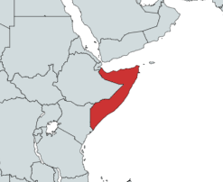
Somalia is a country located in the Horn of Africa which officially consists of the intra-46th meridian east territory, the seven federal member states, namely Galmudug, Hirshabelle, Jubaland, South West, Puntland, and the municipality of Benadir. It is bordered by Ethiopia to the west, the Gulf of Aden to the north, the Somali Sea and Guardafui Channel to the east, and Kenya to the southwest. With a land area of 637,657 square kilometers, Somalia's terrain consists mainly of plateaus, plains and highlands. Its coastline is more than 3,333 kilometers in length, the longest of mainland Africa. It has been described as being roughly shaped "like a tilted number seven".

The Transverse Ranges are a group of mountain ranges of southern California, in the Pacific Coast Ranges physiographic region in North America. The Transverse Ranges begin at the southern end of the California Coast Ranges and lie within Santa Barbara, Ventura, Los Angeles, San Bernardino, Riverside and Kern counties. The Peninsular Ranges lie to the south. The name Transverse Ranges is due to their east–west orientation, making them transverse to the general northwest–southeast orientation of most of California's coastal mountains.

Pico de Orizaba, also known as Citlaltépetl, is an active volcano, the highest mountain in Mexico and third highest in North America, after Denali of United States and Mount Logan of Canada. Pico de Orizaba is also the highest volcano in North America. It rises 5,636 metres (18,491 ft) above sea level in the eastern end of the Trans-Mexican Volcanic Belt, on the border between the states of Veracruz and Puebla. The volcano is currently dormant but not extinct, with the last eruption taking place during the 19th century. It is the second most prominent volcanic peak in the world after Mount Kilimanjaro. Pico de Orizaba is ranked 16th by topographic isolation.

The Sierra Madre Oriental is a mountain range in northeastern Mexico. The Sierra Madre Oriental is part of the American Cordillera, a chain of mountain ranges (cordillera) that consists of an almost continuous sequence of mountain ranges that form the western "backbone" of North America, Central America, South America, and Antarctica.

The North American Cordillera, sometimes also called the Western Cordillera of North America, the Western Cordillera, or the Pacific Cordillera, is the North American portion of the American Cordillera, the mountain chain system (cordillera) along the western coast of the Americas. The North American Cordillera covers an extensive area of mountain ranges, intermontane basins, and plateaus in Western and Northwestern Canada, Western United States, and Mexico, including much of the territory west of the Great Plains.

The Sierra de Los Tuxtlas are a volcanic belt and mountain range along the southeastern Veracruz Gulf coast in Eastern Mexico. The Los Tuxtlas Biosphere Reserve includes the coastal and higher elevations of the Sierra de Los Tuxtlas.

The Sierra Madre de Oaxaca pine–oak forests is a tropical and subtropical coniferous forests ecoregion in Southern Mexico.

The Sierra Madre de Oaxaca is a mountain range in southern Mexico. It is primarily in the state of Oaxaca, and extends north into the states of Puebla and Veracruz.

The Petén–Veracruz moist forests is an ecoregion of the tropical and subtropical moist broadleaf forest biome found in Belize, Guatemala, and Mexico.

The Tamaulipan matorral is an ecoregion in the deserts and xeric shrublands biome on the eastern slopes of the Sierra Madre Oriental range in northeastern Mexico. It is a transitional ecoregion between the Tamaulipan mezquital and the Sierra Madre Oriental pine-oak forests to the west and the Veracruz moist forests to the south.

The Trans-Mexican Volcanic Belt pine–oak forests is a subtropical coniferous forest ecoregion of the Trans-Mexican Volcanic Belt of central Mexico.

The Bobos River, also known as the Filobobos or Filo-Bobos River, is a river of Veracruz state of eastern Mexico.

Sotavento Region is one of the regions of Veracruz, Mexico.

The Oaxacan montane forests is a tropical moist broadleaf forest ecoregion in eastern Mexico. It includes a belt of montane tropical forest on the eastern slope of the Sierra Madre de Oaxaca and eastern Trans-Mexican Volcanic Belt ranges. These forests lie between the lowland Petén–Veracruz moist forests and Veracruz moist forests, and the pine–oak forests of the higher mountains.

The Sierra de San Juan Biosphere Reserve is a protected area in Nayarit state of western Mexico. It was established in 2003, and has an area of 198.01 km2. It lies just southwest of the city of Tepic. It protects a portion of the Sierra de San Juan, a mountain range which lies between Tepic and the Pacific Ocean.
Sierra del Abra Tanchipa Biosphere Reserve is a protected natural area in northeastern Mexico. It is located in the Huasteca Potosina region of San Luis Potosí state, in the eastern foothills of the Sierra Madre Oriental.

Cañón del Río Blanco National Park is protected natural area in Mexico's Veracruz state.
The Chortis Highlands is a highland region in northern Central America, which covers portions of Guatemala, El Salvador, Honduras, and Nicaragua.
