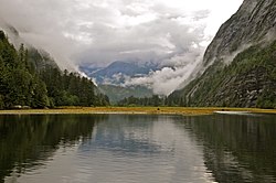
Mussel Inlet is in inlet in the North Coast region of the Canadian province of British Columbia. It is a northeast extension of Sheep Passage, [1] and part of the Fiordland Conservancy.
Mussel Inlet is in inlet in the North Coast region of the Canadian province of British Columbia. It is a northeast extension of Sheep Passage, [1] and part of the Fiordland Conservancy.
It was first charted in 1793 by James Johnstone, one of George Vancouver's officers during his 1791-95 expedition. It was here the men ate mussels that poisoned and killed one of them, John Carter, for whom Carter Bay is named; it is at the junction of Finlayson Channel and the west end of Sheep Passage at 52°49′33″N128°23′46″W / 52.82583°N 128.39611°W . [2] Poison Cove at 52°54′21″N128°02′00″W / 52.90583°N 128.03333°W [3] being the location where the mussels were harvested. [4] A creek northwest into that cove is Poison Cove Creek. [5] [6]

Jervis Inlet is one of the principal inlets of the British Columbia Coast, about 95 km (59 mi) northwest of Vancouver, and the third of such inlets north of the 49th parallel, the first of which is Burrard Inlet, Vancouver's harbour.

Princess Royal Island is the largest island on the North Coast of British Columbia, Canada. It is located amongst the isolated inlets and islands east of Hecate Strait on the British Columbia Coast. At 2,251 square kilometres (869 sq mi), it is the fourth largest island in British Columbia. It was named in 1788 by Captain Charles Duncan, after his ship Princess Royal.
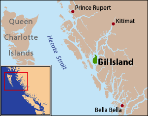
Gil Island is an island on the North Coast of British Columbia, Canada, located on the west side of Whale Channel in the entrance to Douglas Channel, one of the main coastal inlets, on the route of the Inside Passage between Pitt Island and Princess Royal Island. It is 26 km (16 mi) long, with a width ranging from 6 to 13 km, and an area of 231 km2. The only named summit on the mountainous island is Mount Gil, which faces the opening of Douglas Channel.

The Gwa'Sala-Nakwaxda'xw Nations are a union of two Kwakwaka'wakw peoples in a band government based on northern Vancouver Island in British Columbia, Canada, whose main reserve community is near the town of Port Hardy in the Queen Charlotte Strait region of the Central Coast region of British Columbia, Canada. The band government is a member of the Kwakiutl District Council and, for treaty negotiation purposes, the Winalagalis Treaty Group which includes three other members of the Kwakiutl District Council.
Ḵwiḵwa̱sut'inux̱w Ha̱xwa'mis, formerly the Kwicksutaineuk-ah-kwa-mish First Nation is a First Nations band government based on northern Vancouver Island in British Columbia, Canada, in the Queen Charlotte Strait region. It is a member of the Musgamagw Tsawataineuk Tribal Council, along with the ‘Namgis First Nation and the Tsawataineuk First Nation. The Kwikwasut'inuxw and Haxwa'mis are two of the many subgroups of the peoples known as Kwakwaka'wakw, which has two meanings: "smoke of the world" or "beach at the north side of the river."

Gilford Island is an island in British Columbia, Canada, between Tribune Channel and Knight Inlet. It has an area of 384 square kilometres (148 sq mi). Turnour Island is to its south, across Tribune Channel; and the entrance to Thompson Sound is to its east.
Campbell Island is an island in the Canadian province of British Columbia, located west of Denny Island and north of Hunter Island, near Milbanke Sound. The Inside Passage waterways of Lama Passage and Seaforth Channel meet at its northern end.
Gribbell Island is an island on the North Coast of British Columbia, Canada, located on the east side of the entrance to Douglas Channel at Wright Sound. Gribble Island Indian Reserve No. 10 is on its west coast, between Verney Passage and Ursula Channel at 53°21′00″N129°08′00″W. The small Wimbledon Range is on the south side of the island, facing the northern extremities of Princess Royal Island to the south, at 53°21′00″N129°02′00″W
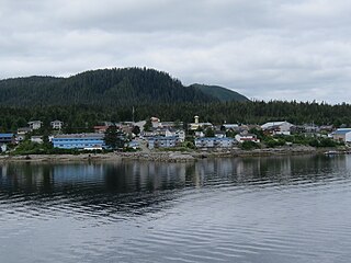
The Hartley Bay Indian Band is also known as the Gitga'at First Nation or the Hartley Bay First Nation. The members of the Gitga'at First nation are often referred to as Gitka'a'ata. The population of Gitk’a’ata peoples living in Hartley Bay ranges from approximately 130-200 people. There are also about 400-500 Gitk’a’ata peoples living in Prince Rupert, British Columbia, Canada, a neighboring territory. The Gitk’a’ata people have lived in Hartley Bay for hundreds of years, if not always. Some notable things regarding the Gitga'at First Nation are their economy, geography, government, sports involvement, COVID-19 regulations, and relations.
Actaeon Sound is a sound in the Queen Charlotte Strait region of the Central Coast of British Columbia, branching off northeasterly from the north side of Drury Inlet near its head on the mainland of British Columbia to the north of the town of Port McNeill, on the opposite side of Queen Charlotte Strait. On the south side of the sound is the Bond Peninsula at 50°56′50″N127°06′55″W, which is formed by a sidewater, Bond Lagoon at 50°56′34″N127°06′34″W, both presumably named in 1865 by Captain Pender, in association with other Admiralty and HMS Actaeon-related names.
Kumealon Inlet is an inlet on the Coast of British Columbia, Canada. It lies on the eastern side of the north end of Grenville Channel facing Pitt Island.
The Chuckwalla River is a river in the Central Coast region of British Columbia, Canada, flowing into Kilbella Bay, which is a side water of Rivers Inlet. The river's headwaters are at 51°52′N127°54′W.
Tribune Channel is a channel or strait on the Central Coast of British Columbia, Canada, separating Gilford Island on the west and north from the mainland. The channel bends around Gilford Island, with the mouth of Thompson Sound at the elbow of the bend, opening eastwards to the mouth of the Kakweiken River.
Naysash Inlet is an inlet on the Central Coast of British Columbia, Canada, branching off the north side of Smith Inlet in the Smith Sound area. Naysash Bay is located just inside the entrance to Naysash Inlet at 51°18′59″N127°20′35″W. Naysash Creek, formerly Boulder Creek, flows southwest into Naysash Inlet at 51°20′21″N127°19′15″W.

East Cracroft Island is an island in the Johnstone Strait region of the Central Coast region of British Columbia, Canada. It is the smaller of the two Cracroft Islands, and at low tide is really one island with its larger neighbour, West Cracroft Island. On the south side of the shallows that form an isthmus between them at low tide is Port Harvey, a short, wide inlet or bay. On its east shore is Keecekiltum Indian Reserve No. 2, which is under the governance of the Tlowitsis Nation of the Kwakwaka'wakw peoples. at 50°33′00″N126°16′00″W.
Drury inlet is an inlet in the Queen Charlotte Strait region of the Central Coast of British Columbia, Canada, extending west from Wells Passage to the northwest of North Broughton Island, northwest of the town of Port Hardy. Branching off to the northeast from the north side of the head of the inlet is Actaeon Sound.
Bonwick Island is an island in the Broughton Archipelago in Central Coast region of the Canadian province of British Columbia. The archipelago is on the northeast side of Queen Charlotte Strait and lies northwest of the village of Alert Bay and immediately to the west of Gilford Island, separated from it by Retreat Pass. Arrow Passage is to its northwest, separating it from Mars Island.
Waddington Harbour is a harbour at the head of Bute Inlet in the Central Coast region of British Columbia, Canada. Also issuing into the head of Bute Inlet and Waddington Harbour, just east of the mouth of the Homathko, is the Teaquahan River. Issuing directly into the inlet a few miles south on the harbour's southeast is the Southgate River, one of the major rivers of the central Pacific Ranges, which begins on the west side of the Lillooet Icecap. Its lower valley adjacent to the inlet's shores is called Pigeon Valley.
Kitkiata Inlet is an inlet on the North Coast of British Columbia, Canada, off the west side of Douglas Channel. Kitkiata Creek flows into the inlet from the north at 53°38′18″N129°16′20″W. Up it at 53°42′51″N129°17′27″W is Kitkiata Lake.
{{cite book}}: CS1 maint: multiple names: authors list (link)52°54′N128°07′W / 52.900°N 128.117°W
| | This article about a location on the North Coast of British Columbia, Canada is a stub. You can help Wikipedia by expanding it. |