
Singida is one of the regions of Tanzania. The regional capital is the municipality of Singida. The region is bordered to the North by Shinyanga Region, Simiyu Region and Arusha Region, to the Northeast by Manyara Region, to the East by Dodoma Region, to the Southeast by Iringa Region, to the Southwest by Mbeya Region and to the West by Tabora Region. It is one of the poorest regions in Tanzania.

Kilimanjaro Region is one of Tanzania's 31 administrative regions with a postcode number 25000. The regional capital is the municipality of Moshi. According to the 2012 national census, the region had a population of 1,640,087, which was lower than the pre-census projection of 1,702,207. For 2002-2012, the region's 1.8 percent average annual population growth rate was the 24th highest in the country. It was also the eighth most densely populated region with 124 people per square kilometer.

Manyara Region is one of Tanzania's 31 administrative regions. The regional capital is the town of Babati. According to the 2012 national census, the region had a population of 1,425,131, which was lower than the pre-census projection of 1,497,555. For 2002-2012, the region's 3.2 percent average annual population growth rate was tied for the third highest in the country. It was also the 22nd most densely populated region with 32 people per square kilometre.

Musoma is a city in north west of Tanzania. It is the capital of Mara Region, one of the administrative Regions of Tanzania. It also serves as the administrative centre of Musoma Rural District and Musoma Urban District.

Arusha Region is one of Tanzania's 31 administrative regions. Its capital and largest city is the city of Arusha. The region is bordered by Kajiado County and Narok County in Kenya to the north, the Kilimanjaro Region to the east, the Manyara and Singida regions to the south, and the Mara and Simiyu regions to the west. Major towns include Monduli, Namanga, Longido, and Loliondo to the north, Mto wa Mbu and Karatu to the west, and Usa River to the east. The region is comparable in size to the combined land and water areas of the United States state of Maryland.

Maswa District is one of the five districts of the Simiyu Region of Tanzania. It is bordered to the north by Magu District and Itilima District, to the east by the Meatu District, to the south by the Kishapu District, and to the west by the Kwimba District. Its administrative centre is the town of Maswa.
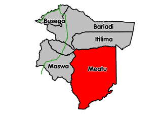
Meatu District CouncilWilaya Ya MeatuHalmashauri ya Wilaya Meatu

Nzega District is one of the seven districts of the Tabora Region of Tanzania. It is bordered to the north by Shinyanga Region, to the south and southwest by the Uyui District and to the east by the Igunga District. Its administrative seat is the town of Nzega.
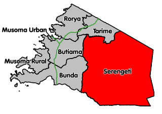
Serengeti District is one of the seven districts of Mara Region of Tanzania. Its administrative centre is the town of Mugumu. It is home to part of the world-famous Serengeti National Park and contains one of the western gates to the park.

Arusha Urban District is one of the seven districts of the Arusha Region of Tanzania, and it contains the regional and economic capital; the city of Arusha. It is bordered to the south, west and north by Arusha Rural District and to east by Meru District. As of 1994, Arusha District was the wealthiest district in Tanzania with 91,024 Tanzanian shillings.

Same is one of the seven districts of the Kilimanjaro Region of Tanzania. It is bordered to the north by the Mwanga District, to the northeast by Kenya, to the south and southeast by the Tanga Region, and to the west by the Manyara Region. The district capital is the town of Same, Tanzania.

The Moshi District Council is one of the seven administrative councils of the Kilimanjaro Region of Tanzania. The council is bordered to the North by the Rombo District, to the West by the Hai District, to the East by the Mwanga District and Kenya, and to the South by the Arusha Region district.

Iramba is one of the six districts of the Singida Region of central Tanzania. It is bordered to the Northwest by the Shinyanga Region, to the North by Simiyu Region, to the east by the Mkalama District, to the South by Ikungi District and to the West by the Tabora Region. Its administrative seat is the town of Kiomboi].

Butiama District is one of the seven districts of Mara Region of Tanzania. Its administrative centre is the town of Butiama. Julius Nyerere was born in Butiama; the Mwalimu Nyerere Museum is located in his town of birth.

Singida, is a city in central Tanzania. The city is the location of the regional headquarters of Singida Region as well as the district headquarters of Singida Urban District. The region and district are named after the town.
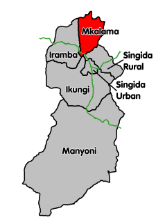
Mkalama District is one of the six districts of the Singida Region of Tanzania. It is one of the 20 new districts that were formed in Tanzania since 2010; it was split off from Iramba District. Mkalama District is bordered to the north by Simiyu Region and Arusha Region, to the east by Manyara Region, to the south by Singida Rural District and to the west by Iramba District.

Arusha Rural District is one of the six districts of the Arusha Region of Tanzania. It is bordered to the north by Longido District, to the east by Meru District, to the south by Kilimanjaro Region, to the west by Monduli District, and it surrounds Arusha City.

Babati Urban District is one of the six districts of the Manyara Region of Tanzania. Babati Urban District is surrounded by Babati Rural District. The administrative capital of the district is Babati town.


