
Myall Lakes National Park is a national park located in New South Wales, Australia, 236 kilometres (147 mi) north of Sydney. It encompasses one of the state's largest coastal lake systems Myall Lakes, and includes Broughton Island. The park includes 40 kilometres of beaches and rolling sand dunes. Myall Lakes is also one of the most visited parks in New South Wales.
The Australian Antarctic Division (AAD) is a division of the Department of the Environment. The Division undertakes science programs and research projects to contribute to an understanding of Antarctica and the Southern Ocean. It conducts and supports collaborative research programs with other Australian and international organisations, such as the Bureau of Meteorology and Geoscience Australia, as well as administering and maintaining a presence in Australian Antarctic and sub-Antarctic territories.

The Australian Antarctic Territory (AAT) is a part of Antarctica administered by the Australian Antarctic Division, an agency of the federal Department of the Environment and Energy. The territory's history dates to a claim on Enderby Land made by the United Kingdom in 1841, which was subsequently expanded and eventually transferred to Australia in 1933. It is the largest territory of Antarctica claimed by any nation by area. In 1961, the Antarctic Treaty came into force. Article 4 deals with territorial claims, and although it does not renounce or diminish any preexisting claims to sovereignty, it also does not prejudice the position of Contracting Parties in their recognition or non-recognition of territorial sovereignty. As a result, only four other countries; New Zealand, the United Kingdom, France and Norway recognise Australia's claim to sovereignty in Antarctica.

Myall Lakes, a series of fresh water lakes protected under the Ramsar Convention, are located within the Mid-Coast Council local government area in the Mid North Coast region of New South Wales, Australia.
The Australian National Antarctic Research Expeditions is the historical name for the Australian Antarctic Program (AAp) administered for Australia by the Australian Antarctic Division (AAD).

The Myall Creek massacre at Myall Creek near the Gwydir River, in the central New South Wales district of Namoi, involved the brutal killing of at least twenty-eight unarmed Indigenous Australians by eleven colonists on 10 June 1838 at the Myall Creek near Bingara, Murchison County, in northern New South Wales. After two trials, seven of the eleven colonists were found guilty of murder and hanged.

Biscoe Islands is a series of islands, of which the principal ones are Renaud, Lavoisier, Watkins, Krogh, Pickwick and Rabot, lying parallel to the west coast of Graham Land and extending 150 km (81 nmi) between Southwind Passage on the northeast and Matha Strait on the southwest. Another group of islands are the Adolph Islands.

Denman Glacier is a glacier 7 to 10 nautical miles wide, descending north some 70 nautical miles, which debouches into the Shackleton Ice Shelf east of David Island, Queen Mary Land. It was discovered in November 1912 by the Western Base party of the Australasian Antarctic Expedition under Sir Douglas Mawson. Mawson named the glacier for Lord Denman, Governor-General of Australia in 1911, a patron of the expedition.

Myall Lakes is an electoral district of the Legislative Assembly in the Australian state of New South Wales. It is represented by Stephen Bromhead of The Nationals.

Bulahdelah is a town and locality in the Hunter/Mid North Coast region of New South Wales, Australia in the Mid-Coast Council local government area. At the 2016 census, the locality had a population of 1,424. The main population centre, where 69% of the area's population lived in 2006, is the town of Bulahdelah.

Myall River, an open semi-mature brackish freshwater barrier estuary of the Mid-Coast Council system, is located in the Mid North Coast region of New South Wales, Australia.
The Australian Antarctic Names and Medals Committee (AANMC) was established to advise the Government on names for features in the Australian Antarctic Territory and the subantarctic territory of Heard Island and the McDonald Islands. The committee also issues nominations Governor General for the award of the Australian Antarctic Medal.
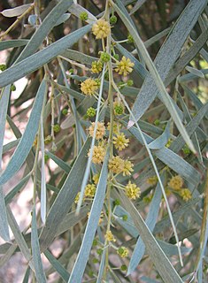
Acacia pendula, the weeping myall, is a species of wattle, which is native to Australia. It is a tree, which grows up to 10 m in height, and is pendulous in form with grey-green narrow phyllodes which are about 10 cm in length.

Endurance Glacier is a broad glacier north of Mount Elder, draining south-east to the south coast of Elephant Island in the South Shetland Islands of Antarctica, and is the main discharge glacier on the island. It was named by the UK Antarctic Place-Names Committee after HMS Endurance, which anchored off the glacier on several occasions in support of the Joint Services Expedition to Elephant Island, 1970–71.

Antarctica is Earth's southernmost continent. It contains the geographic South Pole and is situated in the Antarctic region of the Southern Hemisphere, almost entirely south of the Antarctic Circle, and is surrounded by the Southern Ocean. At 14,200,000 square kilometres, it is the fifth-largest continent. For comparison, Antarctica is nearly twice the size of Australia. About 98% of Antarctica is covered by ice that averages 1.9 km in thickness, which extends to all but the northernmost reaches of the Antarctic Peninsula.

Broughton Island is an island 14 km north-east of Port Stephens, New South Wales, Australia. It is part of the Myall Lakes National Park.(map)
The Southern Ocean, also known as the Antarctic Ocean or the Austral Ocean, and the "Southern Icy Ocean".</ref> comprises the southernmost waters of the World Ocean, generally taken to be south of 60° S latitude and encircling Antarctica. As such, it is regarded as the fourth largest of the five principal oceanic divisions: smaller than the Pacific, Atlantic, and Indian Oceans but larger than the Arctic Ocean. This ocean zone is where cold, northward flowing waters from the Antarctic mix with warmer subantarctic waters.

Posadowsky Glacier is a glacier about 9 nautical miles long, flowing north to Posadowsky Bay immediately east of Gaussberg. Posadowsky Bay is an open embayment, located just east of the West Ice Shelf and fronting on the Davis Sea in Kaiser Wilhelm II Land. Kaiser Wilhelm II Land is the part of East Antarctica lying between Cape Penck, at 87°43'E, and Cape Filchner, at 91°54'E, and is claimed by Australia as part of the Australian Antarctic Territory. Other notable geographic features in this area include Drygalski Island, located 45 mi NNE of Cape Filchner in the Davis Sea, and Mirny Station, a Russian scientific research station.
Smiths Lake, an intermittently closed youthful saline coastal lagoon, is located within the Mid-Coast Council local government area in the Mid North Coast region of New South Wales, Australia. Smiths Lake is located adjacent to the village of Smiths Lake, and adjacent to the east coast, about 274 kilometres (170 mi) north of Sydney.

Myall Creek is a locality split between the local government areas of Inverell Shire and the Gwydir Shire in New South Wales, Australia. In the 2016 census, Myall Creek had a population of 38 people.


