Zschopau, is a town in the Erzgebirgskreis district of Saxony, Germany.

Böhlen is a town in the Free State of Saxony, Germany, south of Leipzig. Its main features are a small airport and a power-plant. It is located in the newly built Neuseenland, the lakes created in the former open-pit mining areas.

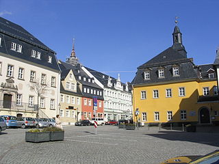
Bad Gottleuba-Berggießhübel is a spa town in the district Sächsische Schweiz-Osterzgebirge in the Free State of Saxony, Germany. The municipality borders the Czech Republic in the south. The municipality was formed on 1 January 1999 by the merger of the former municipalities Bad Gottleuba, Berggießhübel, Langenhennersdorf and Bahratal. Surrounded by forests and near a water dam Bad Gottleuba-Berggießhübel has several facilities, including a spa health park, a plant garden and a heated open air pool.

Auerbach is a town in the Vogtlandkreis, Saxony, Germany. It is the regional centre of the eastern Vogtland. The economy is mainly based on textile manufacturing, food processing and machine industry. After Plauen and Reichenbach, Auerbach is the third most populous town in the Vogtlandkreis.

Reichenbach im Vogtland is a town in the Vogtlandkreis district of Saxony in eastern Germany. With a population of 20,928 (2017-09-30), it is the second largest town in the Vogtlandkreis after Plauen. It lies by the A72 between Plauen and Zwickau.

Vogtland is a region spanning the German states of Bavaria, Saxony and Thuringia and north-western Bohemia in the Czech Republic. It overlaps with and is largely contained within Euregio Egrensis. The name alludes to the former leadership by the Vögte of Weida, Gera and Plauen.

Mittweida is a town in the Free State of Saxony, Germany, in the Mittelsachsen district.

Greiz is a town in Thuringia, and it is the capital of the district of Greiz. Greiz is situated in eastern Thuringia on the river White Elster.

Meerane is a town in the Zwickau district of Saxony, Germany. It lies midway between the towns of Altenburg and Zwickau, west of Chemnitz.

Wolkenstein is a town in the district Erzgebirgskreis, in the Free State of Saxony, Germany. It is situated in the Ore Mountains, on the Zschopau River, 22 km southeast of Chemnitz.

Narsdorf is a former municipality in the Leipzig district, in Saxony, Germany. As of 1 July 2017 Narsdorf has been incorporated into Geithain. The villages of Ossa, and Rathendorf had been incorporated administratively into Narsdorf in 1996, while nearby Seifersdorf had already been incorporated in 1934 and Dölitzsch in 1973.

Großschönau is a municipality in the district Görlitz, in Saxony, Germany located in the Cross-border region with the Czech Republic. It used to be a famous Upper Lusatian center of Damask fabric production until the end of the 1980s. Since then it has turned into an area of tourism.
Seelitz is a municipality in the district of Mittelsachsen, in Saxony, Germany. It is part of the administrative partnership Verwaltungsgemeinschaft Rochlitz based in the eponymous town.

Mylau Castle is a fortification on a spur in Mylau, Vogtland, Saxony, Germany. It is one of the best-preserved medieval castles in Saxony.

The Göltzsch Viaduct is a railway bridge in Germany. It is the largest brick-built bridge in the world, and for a time it was the tallest railway bridge in the world. It spans the valley of the Göltzsch River between Mylau and Netzschkau, around 4 kilometres (2.5 mi) west of Reichenbach im Vogtland in the German Free State of Saxony.

Wildenthal is a village in the town of Eibenstock in the district of Erzgebirgskreis in the Saxon Ore Mountains of Central Germany.
Silberstraße is a formerly independent parish in the German state of Saxony. Since 1999 it has been part of the borough of Wilkau-Haßlau, in the district of Zwickau. It has around 2,000 inhabitants and lies at an elevation of 340 m above sea level (NN). As well as the old village houses it also has a newly built residential area with modern housing units, large industrial estates with textile firms and agricultural concerns.
Dreiskau-Muckern was formed from two villages and is part of Großpösna in the Landkreis Leipzig in Saxony, Germany.
Niederlauterstein is a village in Saxony which has been incorporated into the town of Marienberg in the district Erzgebirgskreis since 1996.
Hundshübel is a village in Erzgebirgskreis district of Saxony, forming a subdivision of the municipality of Stützengrün in the Ore Mountains. It is located north of Eibenstock Dam on federal highway B 169.