
Oulu is a city and municipality of 208 939 inhabitants in the region of North Ostrobothnia, Finland. It is the most populous city in Northern Finland, and the fifth most populous in the country.
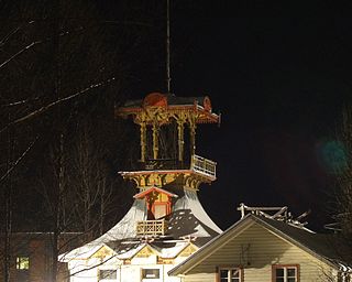
Villa Hannala is a historic villa in Toppilansaari, Oulu, Finland. Located at Kahvelitie 1, the villa was built in 1859 for the Snellman family. Decorations and a tower were added in the 1890s. After surviving the threat of demolition, the building became property of the city of Oulu. In 2004–2007 it was renovated by the adult educational centre of Oulu Polytechnic. Today, the villa is almost fully restored. A café was established for visitors.

Frans Michael Franzén is an outdoor sculpture located in the city centre in Oulu, Finland. It is the eldest public monument in Oulu.

Intiö is a district of the city centre area of Oulu, Finland. It is located on the southern bank of the Oulu River in between Myllytulli and Värttö districts.

The Oulu Museum of Art (OMA) is an art museum in the Myllytulli neighbourhood in Oulu. It is located on the edge of the Hupisaaret Islands park.

Raksila is a District of the city centre area of Oulu, Finland. It is bounded by the Oulu railway station to the west, the Oulu Cemetery in the Intiö district to the north, the Finnish national road 4 to the east and the Finnish national road 22 to the south.

Linnanmaa is a district of the Kaijonharju area of Oulu, Finland. The district is located about five kilometers north of the city centre.

Hollihaka is a district of the city centre area of Oulu, Finland. It is bounded by the estuary of the Oulujoki river to the west, the Vanhatulli district to the north, the Leveri district to the east and the Nuottasaari district to the south. Together with the two latter districts, Hollihaka forms a neighbourhood called Heinäpää.
Pokkinen is a district of the city centre area of Oulu, Finland. Together with districts of Vaara and Vanhatulli, Pokkinen forms the central business district of Oulu. It is bounded by the estuary of the Oulujoki river to the west, the Koskikeskus and Myllytulli districts to the north, the Vaara district to the east and the Vanhatulli district to the south.

Vanhatulli is a district of the city centre area of Oulu, Finland. Together with the districts of Pokkinen and Vaara, Vanhatulli forms the central business district of Oulu. It is bounded by the estuary of the Oulujoki river to the west, the Pokkinen and Vaara districts to the north, the Leveri and Hollihaka districts to the south and the railway to the east.
Vihreäsaari is an uninhabited island and a neighbourhood in the Tuira area in the city of Oulu, Finland. It is separated from the Hietasaari island by the Johteensalmi strait.

Vaara is a district of the city centre area of Oulu, Finland. Together with the districts of Pokkinen and Vanhatulli, Vaara forms the central business district of Oulu. It is bounded by the districts of Raksila to the east, Pokkinen to the west, Myllytulli to the north and Vanhatulli to the south.
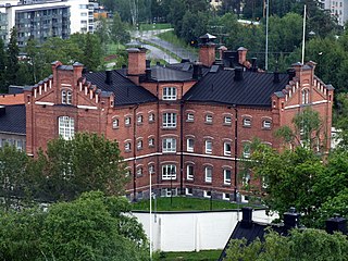
The Oulu Prison is a prison located in the Myllytulli neighbourhood in Oulu, Finland. There are 80 prison places, of which ten are reserved for female prisoners. The mean prison population in 2012 was 87.

Haukipudas is a district of Oulu, Finland. Together with Jokikylä and Martinniemi districts, it forms the Haukipudas area. Haukipudas is located in the river delta of the Kiiminkijoki river. It is bounded by the Bothnian Bay in the west, National road 4 in the east, Martinniemi district in the north and Kello district in the south. The district was established in 2013 when the Haukipudas municipality together with Kiiminki, Oulunsalo and Yli-Ii municipalities were merged with the city of Oulu.

Kiiminki is a district of Oulu, Finland. Together with Alakylä, Hannus and Huttukylä districts, it forms the Kiiminki area. The center of the district is located where the National road 20 crosses the Kiiminkijoki river. The district was established in 2013 when the Kiiminki municipality together with Haukipudas, Oulunsalo and Yli-Ii municipalities were merged with the city of Oulu.

Nuottasaari is a district of Oulu, Finland. It is located south of the city centre of Oulu. Nuottasaari is bounded by the delta of the Oulujoki river in the Northwest, the Bothnian Bay and the Äimärautio district in the South and the Limingantulli, Leveri and Hollihaka districts in the East.

Kontinkangas is a district of Oulu, Finland. It is located to the east of the National road 4 and to the north of the National road 22 about two kilometers from the city centre. Its neighbouring districts are Kaukovainio, Raksila, Peltola and Oulunsuu.

Karjasilta is a district in the Höyhtyä area in the city of Oulu, Finland. The district close to the city centre is bordered by the Raksila district to the north, Finnish national road 4 to the east, the Vanhatulli and Limingantulli districts to the west and the Nokela and Höyhtyä districts to the south.

Martinniemi is a district of Oulu, Finland. Together with Haukipudas and Jokikylä districts, it forms the Haukipudas area. Martinniemi is located in north of the river delta of the Kiiminkijoki river. It is bounded by the Bothnian Bay in the west, the Jokikylä district in the east, the Ii municipality in the north and the Kiiminkijoki river and the Haukipudas district in the south. The district was established in 2013 when the Haukipudas municipality together with Kiiminki, Oulunsalo and Yli-Ii municipalities were merged with the city of Oulu.

The Hupisaaret Islands City Park is a public urban park in the Myllytulli district in central Oulu, Finland. The park is located in the delta of the River Oulu. The area was built as a public park in the 1860s, the first white wooden bridges that characterize the park were also built at the time.
