The Cambrian Railways owned 230 miles (370 km) of track over a large area of mid Wales. The system was an amalgamation of a number of railways that were incorporated in 1864, 1865 and 1904. The Cambrian connected with two larger railways with connections to the northwest of England via the London and North Western Railway, and the Great Western Railway for connections between London and Wales. The Cambrian Railways amalgamated with the Great Western Railway on 1 January 1922 as a result of the Railways Act 1921. The name is continued today in the route known as the Cambrian Line.

Aberangell is a village in Gwynedd, Wales.

The Hendre-Ddu Tramway was a 2 ft narrow gauge industrial railway built in 1867 in Mid-Wales to connect the Hendre-Ddu slate quarry to Aberangell station on the Mawddwy Railway. It consisted of a main line 3+1⁄2 miles (5.6 km) long and several branch lines and spurs serving other quarries, local farms and the timber industry.
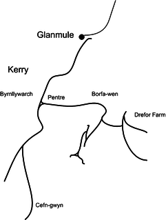
The Kerry Tramway was a 2 ft narrow gauge railway built in 1887 to serve the timber workings and slab quarry to the south of the village of Kerry, near Newtown in mid Wales.
The Mawddwy Railway was a rural line in the Dyfi Valley in mid-Wales that connected Dinas Mawddwy with a junction at Cemmaes Road railway station on the Newtown and Machynlleth Railway section of the Cambrian Railways.
Aberangell railway station was an intermediate railway station on the Mawddwy Railway which ran from Cemmaes Road to Dinas Mawddy in the Welsh county of Merionethshire. The station was opened by the Mawddwy Railway in 1867 and closed to all goods traffic in 1908. The railway re-opened in 1911 with all services run by the Cambrian Railways. It was amalgamated into the Great Western Railway in 1923 as part of the grouping of British railways, and remained open to passenger and freight traffic until 1931 and 1952, respectively. The station was the transshipment point between the branch and the Hendre-Ddu Tramway.
Sir Edmund Buckley, 1st Baronet was a British landowner and Conservative politician who sat in the House of Commons from 1865 to 1878.
The Buckley Baronetcy, of Mawddwy in the County of Merioneth, was created in the Baronetage of the United Kingdom in 1868 for Edmund Buckley, a British landowner and Conservative Party politician. He owned the Hendre Ddu Slate and Slab Company and served from 1865 to 1878 as one of the two Members of Parliament (MPs) for the borough of Newcastle-under-Lyme.

The Dyfi hills are a range situated in the southernmost area of Snowdonia, bounded by the River Dyfi on the east and south sides, by the Afon Dulas on the west and the Afon Cerist to the north. They lie to the west of the Aran Fawddwy range, north-east of the Tarren y Gesail range and are a subgroup of the Cadair Idris group.

The car gwyllt is a Welsh invention used by quarrymen to ride downhill on the steep inclined planes of a slate quarry.
The Meirion Mill Railway was a narrow gauge railway that operated at Meirion Mill in Dinas Mawddwy, Wales. It only operated for three years from 1975 to 1977.

Lewis Cozens was a British railway author and historian, notable as one of the earliest writers on Welsh narrow gauge and light railways.

The Afon Angell is a river in Gwynedd, Mid Wales.

Mynydd Dolgoed or Craig Portas is a mountain in southern Snowdonia, Wales. It is a long ridge running from a low summit between the valleys of the Afon Angell and the Nant Ceiswyn, north east to the cliff of Craig Portas above Dinas Mawddwy. The next mountain in the ridge to south-east is Mynydd Hendre-ddu, while to the south lie Mynydd Llwydiarth and Mynydd Cymerau.

The Nant Llwydiarth is a small river in Mid Wales. It flows from the southern flank of Mynydd Hendre-ddu down to Pont Cymerau, north-east of Aberllefenni. Here it joins the Nant Ceiswyn to form the Afon Dulas that flows south to the Afon Dyfi. There was an ancient bridge at Pont Cymerau.

Mynydd Hendre-ddu or Mynydd Hendreddu is a mountain in southern Snowdonia, Wales. It is one of a line of mountains running from Mynydd Dolgoed in the north, through Mynydd Llwydiarth to Mynydd Hendre-ddu and on to Mynydd y Foel, Y Grug, Mynydd Tri-Arglwyd and Mynydd Gwyn to the south of the village of Aberangell. It forms the watershed between Nant Llwydiarth, which flows to the south-west and into the Afon Dulas, and streams flowing into Afon Angell to the north, which flow east into the River Dyfi.
The Broad Vein Mudstone Formation is an Ordovician lithostratigraphic group in Mid Wales. The rock of the formation is silty mudstone, intensely bioturbated in places. It varies in colour from a pale to a medium blue. This formation has been commercially quarried as slate in several locations along its length. The formation is between 400 metres (1,300 ft) and 560 metres (1,840 ft) thick and runs from Dinas Mawddwy south-west to Cardigan Bay at Tywyn.

The Narrow Vein Mudstone Formation is an Ordovician lithostratigraphic group in Mid Wales. The rock of the formation is silty, homogeneous or finely-laminated mudstone. It generally a medium blue colour. This formation has been commercially quarried as slate in several locations along its length. The formation is between 400 metres (1,300 ft) and 560 metres (1,840 ft) thick and runs from Dinas Mawddwy south-west to Cardigan Bay at Tywyn.
