
The Black Mountains are a group of hills spread across parts of Powys and Monmouthshire in southeast Wales, and extending across the England–Wales border into Herefordshire. They are the easternmost of the four ranges of hills that comprise the Brecon Beacons National Park, and are frequently confused with the westernmost, which is known as the Black Mountain. The Black Mountains may be roughly defined as those hills contained within a triangle defined by the towns of Abergavenny in the southeast, Hay-on-Wye in the north and the village of Llangors in the west. Other gateway towns to the Black Mountains include Talgarth and Crickhowell. The range of hills is well known to walkers and ramblers for the ease of access and views from the many ridge trails, such as that on the Black Hill in Herefordshire, at the eastern edge of the massif. The range includes the highest public road in Wales at Gospel Pass, and the highest point in southern England at Black Mountain.

Bwlch is a small village and an electoral ward in the community of Cwmdu and District, Powys, south Wales. The settlement is strung out along the A40 road which crosses a low col above the Usk Valley at this point on its route between Brecon and Crickhowell.

The Sugar Loaf, sometimes called Sugar Loaf, is a hill situated 2 miles (3.2 km) north-west of Abergavenny in Monmouthshire, Wales and sits within the Brecon Beacons National Park. It is the southernmost of the summit peaks of the Black Mountains, with a height of 1,955 feet (596 metres). Sugar Loaf was gifted to the National Trust by suffragette Lady Rhondda.
Cathedine is a small hamlet that lies between the Brecon Beacons and the Black Mountains, in Powys, Wales. It is an approximately 2 miles from Llangorse and 2 miles from Bwlch, in the community of Llangors.
Twmpa or Lord Hereford's Knob is a mountain in south-east Wales, forming a part of the great northwest scarp of the Black Mountains. It lies 1.86 miles (3 km) west of the border with England, and around 4.34 miles (7 km) south of Hay-on-Wye. To the northeast lies the Gospel Pass through which runs a minor road between Hay and the Llanthony Valley. A ridge known as Darren Lwyd tapers away for about 3 kilometres (1.9 mi) to the southeast of the summit.
Cefn Llechid is a small area of unenclosed land in the Brecon Beacons National Park east of Sennybridge in the county of Powys, Wales. It lies within Fforest Fawr Geopark. Its plateau-like summit surface peaks at 400m where it is marked by a trig point. A couple of small bodies of water lie in a hollow on the plateau. The hill is owned and managed by the Brecon Beacons National Park Authority.

Mynydd Illtud is an extensive area of common land near Libanus, Powys, Wales, located in the Brecon Beacons National Park and some three miles south-west of Brecon. The common is an undulating plateau lying between 330 and 370 metres above sea level. Its highest points are 381 metres (1,250 ft) at Allt Lom and 367 metres (1,204 ft) at Twyn y Gaer trig point overlooking the valley of the River Usk. Twyn y Gaer is the site of an Iron Age hill fort.

The Grwyne Fawr is a river in the Brecon Beacons National Park in south Wales. A section of it forms the administrative border between Powys and Monmouthshire and also of the historic counties of Brecon and Monmouth. The river and its major tributary the Grwyne Fechan flow into the River Usk at Glangrwyney.

Allt yr Esgair is a hill in the Brecon Beacons National Park in Powys, Wales. It is commonly referred to locally as simply 'The Allt'. The Welsh name signifies 'wooded slope of the ridge'. It takes the form of a northwest-southeast aligned ridge which rises to a height of 393m and which overlooks the valley of the River Usk to the west and south. To the northeast are panoramic views across Llangorse Lake to the Black Mountains There is a viewfinder on the summit erected as a monument to Eirene Lloyd White, Baroness White of Rhymney. It is a Marilyn with a prominence of 199 metres.

Y Garn Goch is a hill in the Brecon Beacons National Park in the east of Carmarthenshire, Wales. The name means the 'red cairn'. It lies near the village of Bethlehem, three miles southwest of Llangadog and four miles east of Llandeilo on the southern side of the broad Towy Valley. It is also commonly known as either Garn Goch or Carn Goch. Current owners and land managers are the Brecon Beacons National Park Authority.
Cefn Cul is a hill in the Fforest Fawr sector of the Brecon Beacons National Park in Powys, southern Wales. It is a broad north-northeast to south-southwest aligned ridge whose summit reaches a height of 562 m above sea level. The hill is bounded to the west by the upper valley of the River Tawe though which the old Trecastle road runs whilst to the east is the pass of Bwlch Bryn-rhudd over which the A4067 road runs from the Crai valley south to that of the Tawe.

Trichrug is a hill four miles east of Llandeilo and 3 miles south of Llangadog in the county of Carmarthenshire, southwest Wales. It lies within the Brecon Beacons National Park and Fforest Fawr Geopark. Its summit at a height of 415m above sea level is marked by a trig point. It is a Marilyn with a prominence of 191 metres.

Mynydd Myddfai is a hill 4.5 miles southeast of Llandovery in the county of Carmarthenshire, southwest Wales. It lies within the Brecon Beacons National Park and Fforest Fawr Geopark. The hill is in the form of a broad ridge aligned southwest to northeast with three or four distinct tops separated by cols. The northwest side drops steeply away towards the village of Myddfai whilst the other side is a more shallow slope down towards Glasfynydd Forest which encircles Usk Reservoir. The plateau surface of the hill rises to a height of 440m at OS grid ref SN 806297 where a trig point has been erected.

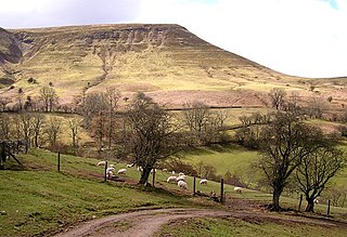
Bryn Arw is a hill in the Black Mountains of the Brecon Beacons National Park in Monmouthshire, south Wales. It lies 4 km north of the town of Abergavenny and 1.5 miles west of the village of Llanvihangel Crucorney. Its summit at 384m above sea level is the more northerly of two tops which lie on the crest of a slightly arcuate north-south ridge which drops away to the south at first gently and then sharply. The hill is isolated from the main mass of the range by the valleys of Cwm Coed-y-cerig to the north and by Cwm Brynarw to the west. It is a Marilyn.
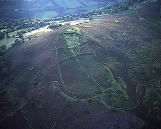
Gaer is the name of a hill in the Black Mountains of the Brecon Beacons National Park in Monmouthshire, south Wales. It lies at the southern end of the long ridge between the valley of the Grwyne Fawr and the Vale of Ewyas one mile to the north of Bryn Arw and 3 miles northeast of Sugarloaf. Its summit at 427m above sea level sits within an Iron Age hillfort known as Twyn y Gaer.
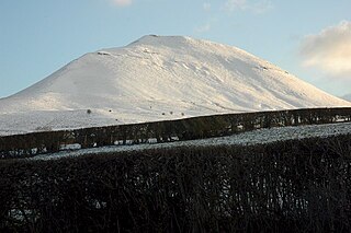
Mynydd Troed is a hill in the Black Mountains of the Brecon Beacons National Park in Powys, south Wales. Its name literally translates to "Foot Mountain," based how it appears when viewed from the Allt Mawr ridge.

The Rhiangoll is a river in the Brecon Beacons National Park in Powys, Wales. It rises on the western slopes of Waun Fach, highest point of the Black Mountains and drops steeply down to the west into the north–south valley through which the A479 runs between Talgarth and the hamlet of Tretower and through the village of Cwmdu. It is joined by various minor tributary streams on its left bank including the Ffinnant, Nant yr Ychen, Nant-y-fedw and Nantygarreg, all of which rise on the flanks of the ridge extending between the Pen Trumau spur of Waun Fach and Pen Gloch-y-pibwr. Two tributary streams flowing from Mynydd Troed and Mynydd Llangorse enter on its right bank as does Nant Ewyn east of the village of Bwlch.

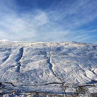
Hay Bluff is a prominent hill at the northern tip of the Black Mountains, an extensive upland massif which straddles the border between south-east Wales and England. The mountain sits at the point where the main northeast-facing escarpment of the Black Mountains meets the northwest facing escarpment, the next peak to the west being Twmpa. The flat summit of Hay Bluff which is marked by a triangulation pillar at a height of 677 metres (2,221 ft) overlooks the middle Wye Valley and the book town of Hay-on-Wye.

Buckland Hill is a low hill in the Brecon Beacons National Park in the county of Powys in Wales. Sitting transversely across the Usk valley between the river and the village of Bwlch, it provides excellent panoramic views down the valley and across to the Black Mountains. The summit at 316m above sea level is marked by an OS trig point though this is now within a dense conifer plantation and so no longer affords any outward views. Buckland Hall sits at the foot of the hill's afforested northwestern side.
This article describes the geology of the Brecon Beacons National Park in mid/south Wales. The area gained national park status in 1957 with the designated area of 1,344 km2 (519 sq mi) including mountain massifs to both the east and west of the Brecon Beacons proper. The geology of the national park consists of a thick succession of sedimentary rocks laid down from the late Ordovician through the Silurian and Devonian to the late Carboniferous period. The rock sequence most closely associated with the park is the Old Red Sandstone from which most of its mountains are formed. The older parts of the succession, in the northwest, were folded and faulted during the Caledonian orogeny. Further faulting and folding, particularly in the south of the park is associated with the Variscan orogeny.

