Bulawayo is the second largest city in Zimbabwe, and the largest city in the country's Matabeleland. The city's population is disputed; the 2012 census listed it at 653,337, while the Bulawayo City Council claimed it to be about 1.2 million. Bulawayo covers an area of about 1,707 square kilometres (659 sq mi) in the western part of the country, along the Matsh' Amhlope River. Along with the capital Harare, Bulawayo is one of two cities in Zimbabwe that are also a province.

West Nicholson or Tshabezi is a village in the province of Matabeleland South, Zimbabwe. It is located about halfway between Zimbabwe's second largest city, Bulawayo, and the border town to South Africa, Beitbridge, along the main road and rail link to South Africa.
For the Dion Boucicault play, please see The Colleen Bawn
Mbalabala is a village on the main Beitbridge-Bulawayo road in Matabeleland, Zimbabwe. Situated approximately 41 miles (66 km) south-east of the city of Bulawayo. The name is derived from the Ndebele name for the greater kudu. It was originally rendered Balla Balla by Europeans, which was altered to its present name in 1982 by the Zimbabwean government in order to coincide closer with the local pronunciation.

Mwenezi River is a major tributary of the Limpopo River. The Mwenezi River starts up in south central Zimbabwe and flows south-east along what is known as the Mwenezi River Valley that bisects the district into two sectors. The river is found in both Zimbabwe and Mozambique. In Zimbabwe it has been known as the Nuanetsi or Nuanetzi River in the past, a name it retains in Mozambique.

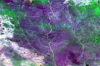
The Insiza River is the principal tributary of the Mzingwane River in Zimbabwe.

The Thuli River, former name Tuli River, is a major tributary of the Shashe River in Zimbabwe. It rises near Matopo Mission, Matobo District, and flows into the Shashe River near Tuli village.

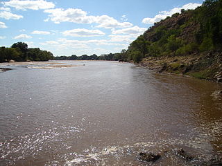
The Mtshabezi River is a tributary of the Thuli River in southern Zimbabwe.
Thuli–Makwe Dam is a reservoir on the Thuli River, west of Gwanda, Zimbabwe with a capacity of 8.3 million cubic metres.

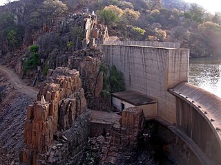
Mtshabezi Dam is a reservoir on the Mtshabezi River, Zimbabwe, with a capacity of 11.4 million cubic metres. After the completion and commissioning of a pipeline linking it to Mzingwane Dam in 2013, Mtshabezi Dam became the city of Bulawayo's 6th supply dam.
Thuli–Moswa Dam is the name for a proposed reservoir on the Thuli River, south of Gwanda, Zimbabwe with a capacity of 419 million cubic metres.
Thuli–Manyange (Elliot) Dam is proposed a reservoir on the Thuli River, south of Gwanda, Zimbabwe with a capacity of 33 million cubic metres. It is designed to be co-operated with Thuli–Moswa Dam

Zhovhe Dam is a reservoir on the Mzingwane River, Zimbabwe with a capacity of 133 million cubic metres. It supplies water for commercial irrigation and the town of Beitbridge.

Glassblock Dam is a proposed reservoir on the Mzingwane River, north of Gwanda, Zimbabwe with a capacity of 14 million cubic meters.
Oakley Block Dam is a proposed reservoir on the Mzingwane River, south of West Nicholson, Zimbabwe with a capacity of 41 million cubic metres.

The Bubye River, also known as Bubi River, is a tributary of the Limpopo River in Beitbridge District and Gwanda District, Zimbabwe. It rises about 40 kilometres (25 mi) to the northeast of West Nicholson in Matabeleland South, from where it flows southeast before joining the Limpopo about 25 kilometres (16 mi) west of the border with Mozambique. Its course forms part of the border between Mberengwa and Mwenezi districts.
Mzingwane High School is a Boys only government secondary school located in the Heart of Matebeleland south as it is the Crown of the Province and it is the only school left in Matebeleland South which is a boys school. Founded in 1921 in Tsholotsho then moved to Essexvale in 1942 ,45km southeast of Bulawayo, .Mzingwane High boards 400+ students. The School motto is Izenzo kunge Mazwi meaning Actions Speak Louder Than Words and the badge represents an Elephant

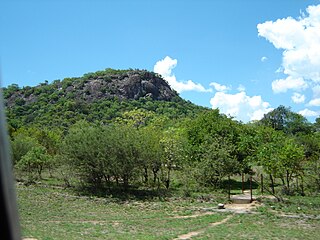
Umzingwane is a district in the northern part of Matabeleland South province in Zimbabwe. It was formerly known as Esigodini District and before 1982 as Essexvale District.