Mzingwane River

Last updated
Mzingwane River
Mzingwane above Fultons Drift 02 03 07.JPG
Mzingwane River above Fulton's Drift (causeway), near Beitbridge, Zimbabwe
Location
Country Zimbabwe
Physical characteristics
Source 
  locationSouth of Bulawayo, Zimbabwe
Mouth  
  location
Limpopo River, South Africa–Zimbabwe border
  coordinates
22°11′13″S29°55′32″E / 22.18694°S 29.92556°E / -22.18694; 29.92556
  elevation
452 m (1,483 ft)
Basin size15,695 km2 (6,060 sq mi)
Discharge 
  average22.30 m3/s (788 cu ft/s)
[1]
Zimbabwe adm location map.svg
Cercle rouge 100%25.svg
Mzingwane
Location of the Mzingwane River's mouth

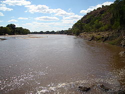
The Mzingwane River, formerly known as Umzingwane River or Umzingwani River, is a major left-bank tributary of the Limpopo River in Zimbabwe. It rises near Fort Usher, Matobo District, south of Bulawayo and flows into the Limpopo River near Beitbridge, downstream of the mouth of the Shashe River and upstream of the mouth of the Bubye River.

Contents

Hydrology

The Mzingwane River is an ephemeral river with flow generally restricted to the months when rain takes place (November to March), with most flow recorded between December and February, except where it has been modified by dam operations. [2] The river contributes 9.3% of the mean annual runoff of the Limpopo Basin, making it the third largest tributary to the Limpopo basin. [1]

Major tributaries of the Mzingwane River include the Insiza, Inyankuni, Ncema, Umchabezi (not to be confused with Mtshabezi) and Mtetengwe Rivers.

The lower Mzingwane River is a sand filled channel, with extensive alluvial aquifers in the river channel and below the alluvial plains. Estimated water resources potential of these aquifers ranges between 175,000 and 5,430,000 cubic metres (6,200,000 and 191,800,000 cu ft) in the channels and between 80,000 and 6,920,000 cubic metres (2,800,000 and 244,400,000 cu ft) in the plains. Currently, some of these aquifers are being used to provide water for domestic use, livestock watering and dip tanks, commercial irrigation and market gardening. [3]

Settlements

The settlements below are ordered from the beginning of the river to its end:

Bridges and crossings

Bertie Knott Bridge on the Mzingwane River near Beitbridge. Bertie Knott Bridge.jpg
Bertie Knott Bridge on the Mzingwane River near Beitbridge.

There are four main bridges over the Mzingwane River:

There are also a number of fords, including:

Development

Spillway of Zhovhe Dam, near Beitbridge. Zhovhe spillway.jpg
Spillway of Zhovhe Dam, near Beitbridge.

In addition to a number of small weirs, there are two major dams on the Mzingwane River:

Additional dam sites have been identified at Glassblock and Oakley Block, but development is not currently scheduled. [5]

A project is underway to construct a pipeline from the upper Mtshabezi River (not to be confused with Umchabezi River) to Mzingwane Dam.

Related Research Articles

<span class="mw-page-title-main">Limpopo River</span> River in southern Africa

The Limpopo River rises in South Africa and flows generally eastward through Mozambique to the Indian Ocean. The term Limpopo is derived from Rivombo (Livombo/Lebombo), a group of Tsonga settlers led by Hosi Rivombo who settled in the mountainous vicinity and named the area after their leader. The river has been called the Vhembe by local Venda communities of the area where now that name has been adopted by the South African government as its District Municipality in the north, a name that was also suggested in 2002 as a possible title for the province but was voted against. The river is approximately 1,750 km (1,090 mi) long, with a drainage basin of 415,000 km2 (160,000 sq mi) in size. The mean discharge measured over a year is 170 m3/s (6,000 cu ft/s) to 313 m3/s (11,100 cu ft/s) at its mouth. The Limpopo is the second largest African river that drains to the Indian Ocean, after the Zambezi River.

<span class="mw-page-title-main">Dolores River</span> River in Colorado and Utah in the United States

The Dolores River is a tributary of the Colorado River, approximately 241 miles (388 km) long, in the U.S. states of Colorado and Utah. The river drains a rugged and arid region of the Colorado Plateau west of the San Juan Mountains. Its name derives from the Spanish El Rio de Nuestra Señora de Dolores, River of Our Lady of Sorrows. The river was explored and possibly named by Juan Maria Antonio Rivera during a 1765 expedition from Santa Fe.

<span class="mw-page-title-main">Feather River</span> River in California, United States

The Feather River is the principal tributary of the Sacramento River, in the Sacramento Valley of Northern California. The river's main stem is about 73 miles (117 km) long. Its length to its most distant headwater tributary is just over 210 miles (340 km). The main stem Feather River begins in Lake Oroville, where its four long tributary forks join—the South Fork, Middle Fork, North Fork, and West Branch Feather Rivers. These and other tributaries drain part of the northern Sierra Nevada, and the extreme southern Cascades, as well as a small portion of the Sacramento Valley. The total drainage basin is about 6,200 square miles (16,000 km2), with approximately 3,604 square miles (9,330 km2) above Lake Oroville.

<span class="mw-page-title-main">Durance</span> River in France

The Durance is a major river in Southeastern France. A left tributary of the Rhône, it is 323.2 km (200.8 mi) long. Its drainage basin is 14,472 km2 (5,588 sq mi).

<span class="mw-page-title-main">Gongola River</span> River in northeastern Nigeria

The Gongola River is in northeastern Nigeria, the principal tributary of the Benue River. The upper course of the river as well as most of its tributaries are seasonal streams, but fill rapidly in August and September. The Gongola rises on the eastern slopes of the Jos Plateau and falls to the Gongola Basin, running northeasterly until Nafada. At one time, the Gongola continued from here in the northeast direction to Lake Chad. Today it turns south and then southeast until it joins the Hawal River, its main tributary. The Gongola then runs south to the Benue river, joining it opposite the town of Numan.

<span class="mw-page-title-main">Daman Ganga River</span> River in western India

The Daman Ganga formerly called the Sandalcalo River is a river in western India. The river's headwaters are on the western slope of the Western Ghats range, and it flows west into the Arabian Sea. The river flows through Maharashtra and Gujarat states, as well as the Union territory of Dadra and Nagar Haveli and Daman and Diu. The industrial towns of Vapi, Dadra and Silvassa lie on the north bank of the river, and the town of Daman occupies both banks of the river's mouth.

Colleen Bawn is a town in Zimbabwe.

<span class="mw-page-title-main">Shashe River</span> River in Botswana, Zimbabwe

The Shashe River is a major left-bank tributary of the Limpopo River in Zimbabwe. It rises northwest of Francistown, Botswana and flows into the Limpopo River where Botswana, Zimbabwe and South Africa meet. The confluence is at the site of the Greater Mapungubwe Transfrontier Conservation Area.

<span class="mw-page-title-main">Mwenezi River</span> River in Zimbabwe, Mozambique

The Mwenezi River, originally known as the Nuanetsi River, is a major tributary of the Limpopo River. The Mwenezi River starts up in south central Zimbabwe and flows south-east along what is known as the Mwenezi River Valley that bisects the district into two sectors. The river is found in both Zimbabwe and Mozambique. In Zimbabwe it has been known as the Nuanetsi or Nuanetzi River in the past, a name it retains in Mozambique.

<span class="mw-page-title-main">Insiza River</span> River in Zimbabwe

The Insiza River is the principal tributary of the Mzingwane River in Zimbabwe.

<span class="mw-page-title-main">Thuli River</span> River in Zimbabwe

The Thuli River, former name Tuli River, is a major tributary of the Shashe River in Zimbabwe. It rises near Matopo Mission, Matobo District, and flows into the Shashe River near Tuli village.

<span class="mw-page-title-main">Mtshabezi River</span> River in southern Zimbabwe

The Mtshabezi River is a tributary of the Thuli River in southern Zimbabwe. Mtshabezi river's source is in Matopos Hills, an area of granite kopjes and wooded valleys commencing some 35 kilometres south of Bulawayo, southern Zimbabwe. It supplys the Mtshabezi Dam which has become the 6th dam to supply is the second largest city in Zimbabwe, Bulawayo.

<span class="mw-page-title-main">Mtshabezi Dam</span> Dam in Zimbabwe

Mtshabezi Dam is a reservoir on the Mtshabezi River, Zimbabwe, with a capacity of 11.4 million cubic metres. After the completion and commissioning of a pipeline linking it to Mzingwane Dam in 2013, Mtshabezi became the sixth dam supplying water to the city of Bulawayo.

Zhovhe Dam is a reservoir on the Mzingwane River, Zimbabwe with a capacity of 133 million cubic metres. It supplies water for commercial irrigation and the town of Beitbridge.

<span class="mw-page-title-main">Mtetengwe River</span>

The Mtetengwe River is a tributary of the Mzingwane River in Beitbridge District, Zimbabwe. There are two dams on its tributaries: Tongwe Dam on the Tongwe River, which provides water for an irrigation scheme, and Giraffe Dam which supplies water for cattle. The Mtetengwe is the last east-bank tributary to join the Mzingwane River.

<span class="mw-page-title-main">Umchabezi River</span>

The Umchabezi River is a tributary of the Mzingwane River in Beitbridge District and Gwanda District, Zimbabwe. The main dam on the Umchabezi is Makado Dam, which supplies water for commercial irrigation.

<span class="mw-page-title-main">Bubye River</span> River in Zimbabwe

The Bubye River, also known as Bubi River, is a tributary of the Limpopo River in Beitbridge District and Gwanda District, Zimbabwe. It rises about 40 kilometres (25 mi) to the northeast of West Nicholson in Matabeleland South, from where it flows southeast before joining the Limpopo 25 kilometres (16 mi) west of the border with Mozambique. Its course forms part of the border between Mberengwa and Mwenezi districts.

The Motloutse River is a river in Botswana, a tributary of the Limpopo River. The catchment area is 19,053 square kilometres (7,356 sq mi).The Letsibogo Dam on the Motloutse has been built to serve the industrial town of Selebi-Phikwe and surrounding local areas, with potential for use in irrigation.

<span class="mw-page-title-main">Umzingwane District</span> Administrative district in Matabeleland South, Zimbabwe

Umzingwane is a district in the northern part of Matabeleland South province in Zimbabwe. It was formerly known as Esigodini and before 1982 as Essexvale.

References

  1. 1 2 Görgens, A.H.M.; Boroto, R.A. (1997). Limpopo River: flow balance anomalies, surprises and implications for integrated water resources management. Proceedings of the 8th South African National Hydrology Symposium. Pretoria.
  2. Love, D., Uhlenbrook, S., Nyabeze, W., Owen, R.J.S., Twomlow, S., Savenije, H. , Woltering, L. and van der Zaag, P. 2005. Modelling of hydrological change for IWRM planning: case study of the Mzingwane River, Limpopo Basin, Zimbabwe. In: Abstract Volume, 6th WaterNet/WARFSA/GWP-SA Symposium, Ezulwini, Swaziland, November 2005, p31.
  3. Moyce, W., Mangeya, P., Owen, R. and Love, D. 2006. Alluvial aquifers in the Mzingwane Catchment: their distribution, properties, current usage and potential expansion. Physics and Chemistry of the Earth, 31, 988-994.
  4. "Beitbridge". Archived from the original on 2016-11-06. Retrieved 2012-03-18.
  5. Chibi, T.; Kandori, C.; Makone, B.F. (2005). Mzingwane Catchment Outline Plan. Bulawayo: Zimbabwe National Water Authority.