
The Chiredzi River is a river in southeastern Zimbabwe. It is a tributary of the Runde River, and is dammed at Manjirenji Dam, which is recognised as an important wetland. [1]
The Chiredzi River is a river in southeastern Zimbabwe. It is a tributary of the Runde River, and is dammed at Manjirenji Dam, which is recognised as an important wetland. [1]

The Zambezi River is the fourth-longest river in Africa, the longest east-flowing river in Africa and the largest flowing into the Indian Ocean from Africa. The area of its basin is 1,390,000 square kilometres (540,000 sq mi), slightly less than half of the Nile's. The 2,574-kilometre-long river (1,599 mi) arises in Zambia and flows through eastern Angola, along the north-eastern border of Namibia and the northern border of Botswana, then along the border between Zambia and Zimbabwe to Mozambique, where it crosses the country to empty into the Indian Ocean.

A bog or bogland is a wetland that accumulates peat, a deposit of dead plant material—often mosses, and in a majority of cases, sphagnum moss. It is one of the four main types of wetlands. Other names for bogs include mire, mosses, quagmire, and muskeg; alkaline mires are called fens. A baygall is another type of bog found in the forest of the Gulf Coast states in the United States. They are often covered in heath or heather shrubs rooted in the sphagnum moss and peat. The gradual accumulation of decayed plant material in a bog functions as a carbon sink.

The littoral zone or nearshore is the part of a sea, lake, or river that is close to the shore. In coastal environments, the littoral zone extends from the high water mark, which is rarely inundated, to shoreline areas that are permanently submerged. The littoral zone always includes this intertidal zone, and the terms are often used interchangeably. However, the meaning of littoral zone can extend well beyond the intertidal zone.

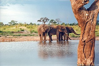
Gonarezhou National Park is a national park located in south-eastern Zimbabwe. It is situated in a relatively remote corner of Masvingo Province, south of Chimanimani along the Mozambique border. Owing to its vast size, rugged terrain and its location away from main tourist routes, large tracts of Gonarezhou remain as pristine wilderness.
Hwange National Park is the largest natural reserve in Zimbabwe. The park lies in the west, on the main road between Bulawayo and the Victoria Falls and near to Dete.

The Runde River is a river in southeastern Zimbabwe. It is a tributary of the Save River and its major tributaries include the Ngezi River, Tokwe River, Mutirikwe River and Chiredzi River.

Mana Pools National Park is a 219,600 ha wildlife conservation area and national park in northern Zimbabwe. It is a region of the lower Zambezi River in Zimbabwe where the flood plain turns into a broad expanse of lakes after each rainy season. As the lakes gradually dry up and recede, the region attracts many large animals in search of water, making it one of Africa's most renowned game-viewing regions.

The Kalahari Basin, also known as the Kalahari Depression or the Okavango Basin, is an endorheic basin and large lowland area covering over 2.5 million km2 covering most of Botswana and Namibia, as well as parts of Angola, South Africa, Zambia, and Zimbabwe. The outstanding physical feature in the basin, and occupying the centre, is the large Kalahari Desert.

Chiredzi is a small town in Masvingo province in south-east Zimbabwe. It is located near the Runde River, which has a tributary called the 'Chiredzi'. As the administrative center for Chiredzi District, it is where both the rural and district councils are based.

A wet meadow is a type of wetland with soils that are saturated for part or all of the growing season. Debate exists whether a wet meadow is a type of marsh or a completely separate type of wetland. Wet prairies and wet savannas are hydrologically similar. Wet meadows may occur because of restricted drainage or the receipt of large amounts of water from rain or melted snow. They may also occur in riparian zones and around the shores of large lakes.

The Mazowe Dam is a dam on the Mazowe River in Zimbabwe, in the Iron Mask Hills about 35 kilometres (22 mi) north of Harare. Constructed in 1920, it was built mainly to provide irrigation for the Mazoe citrus estates. The dam was also home to the Hunyani Rowing Club and formerly provided facilities for St. Georges, Prince Edward, Arundel and other rowing clubs. It is the only major dam on the Mazowe River.

The Shashe River is a major left-bank tributary of the Limpopo River in Zimbabwe. It rises northwest of Francistown, Botswana and flows into the Limpopo River where Botswana, Zimbabwe and South Africa meet. The confluence is at the site of the Greater Mapungubwe Transfrontier Conservation Area.
Manyuchi Dam forms a reservoir on the Mwenezi River in southern Zimbabwe. It is located in the Mwenezi District. The building of the dam was financed by the Mwenezi Development Corporation. The dam was built to irrigate oil palm estates.

Chiredzi found in the district, is one of a number of centers for HIV/AIDS treatment in the province. The district's Hippo Valley Hospital is one of a number of centers for HIV/AIDS treatment in the province. The district is famous for hosting Hippo Valley Estate and the nearby Mkwasine Estate, both of which specialize in sugar cane and citrus fruit production.

Mwenezi River is a major tributary of the Limpopo River. The Mwenezi River starts up in south central Zimbabwe and flows south-east along what is known as the Mwenezi River Valley that bisects the district into two sectors. The river is found in both Zimbabwe and Mozambique. In Zimbabwe it has been known as the Nuanetsi or Nuanetzi River in the past, a name it retains in Mozambique.

The Paroo-Darling National Park is a protected national park that is located in the Far West region of New South Wales, in eastern Australia. The 178,053-hectare (439,980-acre) national park spans two distinct regions in the outback area. This region covers the arid catchments of the Paroo River and the Paroo-Darling confluence to the south.
The Mutirikwe River is a river in southeastern Zimbabwe. It is a tributary of the Runde River and its major tributaries include Pokoteke River.

The Southern Ewaso Ng'iro is a river in the Great Rift Valley in Kenya. It plays an important role in the ecology of Lake Natron, the main regular breeding site for near-threatened lesser flamingos. Changes to land use in the river's headwaters or in the marshes before the river enters the lake could have a serious impact on this species.

The A10 Highway is a primary road that runs from Ngundu in south Masvingo Province to Tanganda through the Mutare-Masvingo Highway in Manicaland Province.
| Authority control |
|
|---|
Coordinates: 21°11′33″S31°51′44″E / 21.1925°S 31.8623°E