Related Research Articles

The Kariba Dam is a double curvature concrete arch dam in the Kariba Gorge of the Zambezi river basin between Zambia and Zimbabwe. The dam stands 128 metres (420 ft) tall and 579 metres (1,900 ft) long. The dam forms Lake Kariba, which extends for 280 kilometres (170 mi) and holds 185 cubic kilometres (150,000,000 acre⋅ft) of water.

The Zambezi is the fourth-longest river in Africa, the longest east-flowing river in Africa and the largest flowing into the Indian Ocean from Africa. Its drainage basin covers 1,390,000 km2 (540,000 sq mi), slightly less than half of the Nile's. The 2,574-kilometre-long (1,599 mi) river rises in Zambia and flows through eastern Angola, along the north-eastern border of Namibia and the northern border of Botswana, then along the border between Zambia and Zimbabwe to Mozambique, where it crosses the country to empty into the Indian Ocean.
Kariba is a resort town in Mashonaland West province, Zimbabwe, located close to the Kariba Dam at the north-eastern end of Lake Kariba, near the Zambian border. According to the 2022 Population Census, the town had a population of 27,600.

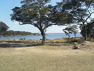
Lake Kariba is the world's largest artificial lake and reservoir by volume. It lies 1,300 kilometres (810 mi) upstream from the Indian Ocean, along the border between Zambia and Zimbabwe. Lake Kariba was filled between 1958 and 1963 following the completion of the Kariba Dam at its northeastern end, flooding the Kariba Gorge on the Zambezi River.

Zimbabwe Parks and Wildlife Management Authority (Zimparks) is an agency of the Zimbabwe government managing national parks. Zimbabwe's game reserves are managed by the government. They were initially founded as a means of using unproductive land.
Kariba is a district and constituency on the shores of Lake Kariba in the Mashonaland West Province of northern Zimbabwe, along the border with Zambia. The constituency comprises 12 rural wards or municipalities in Kariba Rural, also known as Nyaminyami Rural District, and 9 urban wards in Kariba Town, the district capital. The district's total population was just under 60,000 in 2011. Kariba town was built to house the workers who built Kariba Dam, which was completed in 1960 to supply Zimbabwe and Zambia with hydroelectric power, and which gave rise to one of the largest artificial lakes in the world. The creation of the Kariba Lake led to a thriving fishing industry, but following Zimbabwe's economic collapse, Kariba became the least developed district in the country. Kariba is also the most isolated district in Zimbabwe, with no tarred roads as of 2002. The main economic activities are subsistence agriculture, fishing and subsistence hunting. The district, which includes Matusadona National Park, suffers from high levels of wildlife poaching and high levels of human-wildlife conflict.
Norton is a commuter town in the province of Mashonaland West, Zimbabwe near Harare. It is located about 40 km west of Harare on the main road and railway line connecting Harare and Bulawayo.

The Kalahari Basin, also known as the Kalahari Depression, Okavango Basin or the Makgadikgadi Basin, is an endorheic basin and large lowland area covering approximately 725,293 km2 - mostly within Botswana and Namibia, but also parts of Angola, South Africa, Zambia, and Zimbabwe. The outstanding physical feature in the basin, and occupying the centre, is the large Kalahari Desert.

Lake Mutirikwi, originally known as Lake Kyle or Kyle Dam, lies in south eastern Zimbabwe, south east of Masvingo. It is thought to have been named after Kyle Farm which occupied most of the land required for the lake, which in turn was named after the Kyle district in Scotland from which the pioneer of the Lowveld, Tom Murray MacDougall came originally.
Lake Chivero is a reservoir on the Manyame River in Zimbabwe. It was formerly called Lake McIlwaine in memory of Sir Robert McIlwaine, a former judge of the High Court and founder of Southern Rhodesia's soil and water conservation movement.
Kariba Gorge is a large, natural gorge through which flowed the Zambezi River on the border of Zambia and Zimbabwe, Africa. In 1959 the large double arch concrete Kariba Dam was completed, completely filling the gorge and creating the largest man-made lake in the world. Lake Kariba was filled between 1958 and 1963 following the completion of the Kariba Dam at its northeastern end, flooding the Kariba Gorge on the Zambezi River and displacing large numbers of wildlife and the local Tonga people.
Manyuchi Dam forms a reservoir on the Mwenezi River in southern Zimbabwe. It is located in the Mwenezi District. The building of the dam was financed by the Mwenezi Development Corporation. The dam was built to irrigate oil palm estates.

The Insiza River is the principal tributary of the Mzingwane River in Zimbabwe.

The Mtshabezi River is a tributary of the Thuli River in southern Zimbabwe. Mtshabezi river its scource is up from Matopos Hills, an area of granite kopjes and wooded valleys commencing some 35 kilometres south of Bulawayo, southern Zimbabwe. It supplys the Mtshabezi Dam which has become the 6th dam to supply is the second largest city in Zimbabwe, Bulawayo is the largest city in the country's Matabeleland region. The city's population is disputed; the 2022 census listed it at 665,940,[4] while the Bulawayo City Council claimed it to be about 1.2 million.

The Odzi River is a tributary of the Save River in Zimbabwe. It joins the latter river at Nyanyadzi. It is dammed at Osborne Dam.
The Osborne Dam site on the Odzi River, Zimbabwe, was identified in the 1950s by the planning engineers of the Ministry of Water. Cored drilling investigations on the two possible alignments were completed in the 1960s. After the completion of Mazvikadei dam [1985–'88] under Italian aid finance, further funding became available for the project and when the 10 000 hectares of potential irrigable land was identified downstream the project was approved in 1989 by the multi-ministry irrigation committee of the Zimbabwe Government.

The Bubye River, also known as Bubi River, is a tributary of the Limpopo River in Beitbridge District and Gwanda District, Zimbabwe. It rises about 40 kilometres (25 mi) to the northeast of West Nicholson in Matabeleland South, from where it flows southeast before joining the Limpopo about 25 kilometres (16 mi) west of the border with Mozambique. Its course forms part of the border between Mberengwa and Mwenezi districts.
The Mutirikwe River is a river in southeastern Zimbabwe. It is a tributary of the Runde River and its major tributaries include Pokoteke River.
The Chiredzi River is a river in southeastern Zimbabwe. It is a tributary of the Runde River, and is dammed at Manjirenji Dam, which is recognised as an important wetland.
Bangala Dam lies in south-eastern Zimbabwe, south of Masvingo. It was built by Concor to provide irrigation water to the farming estates on the lowveld to the southwest, around the town of Triangle, where the main crop has been sugar cane.
References
- 1 2 "Manjirenji Dam". Zimbabwe National Water Authority. Archived from the original on 18 June 2013. Retrieved 13 January 2010.
| | This article about a building or structure in Zimbabwe is a stub. You can help Wikipedia by expanding it. |