
Botswana, officially the Republic of Botswana, is a landlocked country in Southern Africa. Botswana is topographically flat, with approximately 70 percent of its territory being the Kalahari Desert. It is bordered by South Africa to the south and southeast, Namibia to the west and north, and Zimbabwe to the northeast. It is connected by the Kazungula Bridge to Zambia, across the world's shortest border between two countries.

The Zambezi is the fourth-longest river in Africa, the longest east-flowing river in Africa and the largest flowing into the Indian Ocean from Africa. Its drainage basin covers 1,390,000 km2 (540,000 sq mi), slightly less than half of the Nile's. The 2,574 km (1,599 mi) river rises in Zambia and flows through eastern Angola, along the north-eastern border of Namibia and the northern border of Botswana, then along the border between Zambia and Zimbabwe to Mozambique, where it crosses the country to empty into the Indian Ocean.
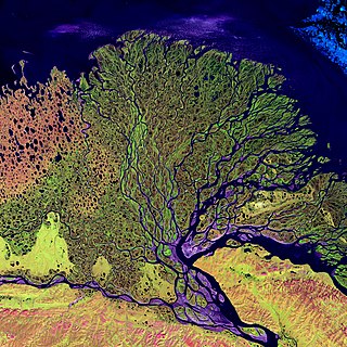
A river delta is a landform shaped like a triangle, created by the deposition of sediment that is carried by a river and enters slower-moving or stagnant water. This occurs at a river mouth, when it enters an ocean, sea, estuary, lake, reservoir, or another river that cannot carry away the supplied sediment. It is so named because its triangle shape resembles the uppercase Greek letter delta, Δ. The size and shape of a delta are controlled by the balance between watershed processes that supply sediment, and receiving basin processes that redistribute, sequester, and export that sediment. The size, geometry, and location of the receiving basin also plays an important role in delta evolution.
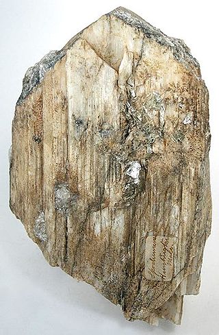
Spodumene is a pyroxene mineral consisting of lithium aluminium inosilicate, LiAl(SiO3)2, and is a commercially important source of lithium. It occurs as colorless to yellowish, purplish, or lilac kunzite (see below), yellowish-green or emerald-green hiddenite, prismatic crystals, often of great size. Single crystals of 14.3 m (47 ft) in size are reported from the Black Hills of South Dakota, United States.

Victoria Falls is a waterfall on the Zambezi River in southern Africa, which provides habitat for several unique species of plants and animals. It is located on the border between Zambia and Zimbabwe and is one of the world's largest waterfalls, with a width of 1,708 m (5,604 ft).

Southern Africa is the southernmost region of Africa. No definition is agreed upon, but some groupings include the United Nations geoscheme, the intergovernmental Southern African Development Community, and the physical geography definition based on the physical characteristics of the land.
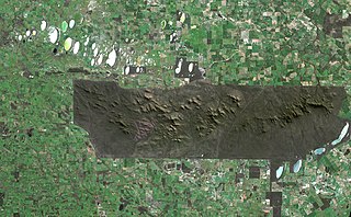
The Stirling Range or Koikyennuruff is a range of mountains and hills in the Great Southern region of Western Australia, 337 kilometres (209 mi) south-east of Perth. It is over 60 kilometres (37 mi) wide from west to east, stretching from the highway between Mount Barker and Cranbrook eastward past Gnowangerup. The Stirling Range is protected by the Stirling Range National Park, which was gazetted in 1913, and has an area of 1,159 km2 (447 sq mi).
The term Southern Australia is generally considered to refer to the states and territories of Australia of New South Wales, Victoria, Tasmania, the Australian Capital Territory and South Australia. The part of Western Australia south of latitude 26° south — a definition widely used in law and state government policy — is also usually included.
Kuznetsk Depression is located among mountains of South-Central Siberia, including: Kuznetsk Alatau to the Northeast, Salair Ridge to the Southwest, and Mountainous Shoria to the South. It is within Kemerovo Oblast.
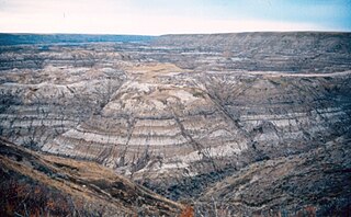
The Horseshoe Canyon Formation is a stratigraphic unit of the Western Canada Sedimentary Basin in southwestern Alberta. It takes its name from Horseshoe Canyon, an area of badlands near Drumheller.

Filabusi is a town in the Matabeleland South Province of Zimbabwe. The town is the district capital of Insiza District and a service centre for the surrounding mining and farming areas.

The Insiza River is the principal tributary of the Mzingwane River in Zimbabwe.
Muller Conrad "Billy" Rautenbach is a Zimbabwean businessman, whose ventures have included companies involved in transport, cobalt and platinum mining, and biofuel production, primarily in Africa. The 2022 Data Leaks at Credit Suisse appeared to confirm allegations – for which he had faced American and European sanctions in earlier years that Rautenbach used the proceeds from a mining deal to support the ZANU-PF regime of dictator Robert Mugabe, during the latter's repressive 2008 election campaign in Zimbabwe. From 1999 to 2009, Rautenbach was a fugitive from fraud and corruption charges in South Africa.
Kavango–Zambezi Transfrontier Conservation Area is the second-largest nature and landscape conservation area in the world, spanning the international borders of five countries in Southern Africa. It includes a major part of the Upper Zambezi River and Okavango basins and Delta, the Caprivi Strip of Namibia, the southeastern part of Angola, southwestern Zambia, the northern wildlands of Botswana and western Zimbabwe. The centre of this area is at the confluence of the Zambezi and Chobe Rivers where the borders of Botswana, Namibia, Zambia and Zimbabwe meet. It incorporates a number of notable national parks and nature sites, including Chobe National Park, Hwange National Park, and the Victoria Falls. The region is home to a population of approximately 250,000 animals, including the largest population of African Elephants in the world.

Cross River is the main river in southeastern Nigeria and gives its name to Cross River State. It originates in Cameroon, where it takes the name of the Manyu River. Although not long by African standards its catchment has high rainfall and it becomes very wide. Over its last 80 kilometres (50 mi) to the sea it flows through swampy rainforest with numerous creeks and forms an inland delta near its confluence with the Calabar River, about 20 kilometres (12 mi) wide and 50 kilometres (31 mi) long between the cities of Oron on the west bank and Calabar, on the east bank, more than 30 kilometres (19 mi) from the open sea. The delta empties into a broad estuary which it shares with a few smaller rivers. At its mouth in the Atlantic Ocean, the estuary is 24 kilometres (15 mi) wide. The eastern side of the estuary is in the neighboring country of Cameroon.
The A5 Highway is a national road in Zimbabwe. It joins the cities of Harare and Bulawayo, and is hence known as the Harare-Bulawayo Highway. It is one of the two routes that form the R2 Route, which connects Harare with the Plumtree Border with Botswana.

Umzingwane is a district in the northern part of Matabeleland South province in Zimbabwe. It was formerly known as Esigodini and before 1982 as Essexvale.
The Tati Goldfields are a mineral-rich band in Botswana and Zimbabwe in southern Africa. The band runs approximately 130 kilometres (81 mi) long by 5 kilometres (3 mi) wide, and crosses the Tati River. It is the southernmost of the gold-bearing bands in the Archaen greenstone (schist) belts of Zimbabwe. It is estimated that between 1866 and 1963 over 200,000 ounces of gold were produced from mines in the Tati Goldfields.
Isseneru is an Amerindian settlement in the Cuyuni-Mazaruni region of Guyana, approximately 15–20 miles west of Kurupung.