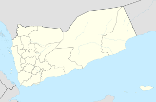
Qishn is a coastal town in Al Mahrah Governorate, seat of Qishn District in southern Yemen. It is located at around 15°25′22″N51°40′53″E. It has a landing strip, which is currently not in use.
Bodzanówek is a village in the administrative district of Gmina Osięciny, within Radziejów County, Kuyavian-Pomeranian Voivodeship, in north-central Poland.

Osówka is a village in the administrative district of Gmina Niemce, within Lublin County, Lublin Voivodeship, in eastern Poland. It lies approximately 13 kilometres (8 mi) west of Niemce and 16 km (10 mi) north-west of the regional capital Lublin.
Tadzin is a village in the administrative district of Gmina Rzgów, within Łódź East County, Łódź Voivodeship, in central Poland. It lies approximately 7 kilometres (4 mi) east of Rzgów and 13 km (8 mi) south-east of the regional capital Łódź.
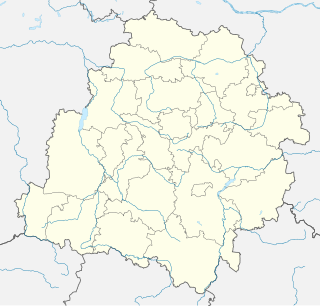
Kolonia Rzejowice is a settlement in the administrative district of Gmina Kodrąb, within Radomsko County, Łódź Voivodeship, in central Poland. It lies approximately 4 kilometres (2 mi) east of Kodrąb, 17 km (11 mi) east of Radomsko, and 79 km (49 mi) south of the regional capital Łódź.
Wólka Babska is a village in the administrative district of Gmina Biała Rawska, within Rawa County, Łódź Voivodeship, in central Poland. It lies approximately 9 kilometres (6 mi) north-west of Biała Rawska, 11 km (7 mi) north-east of Rawa Mazowiecka, and 62 km (39 mi) east of the regional capital Łódź.
Grabice is a village in the administrative district of Gmina Cielądz, within Rawa County, Łódź Voivodeship, in central Poland. It lies approximately 6 kilometres (4 mi) south of Cielądz, 14 km (9 mi) south-east of Rawa Mazowiecka, and 64 km (40 mi) east of the regional capital Łódź.
Zawada is a village in the administrative district of Gmina Ożarów, within Opatów County, Świętokrzyskie Voivodeship, in south-central Poland. It lies approximately 4 kilometres (2 mi) south of Ożarów, 20 km (12 mi) east of Opatów, and 75 km (47 mi) east of the regional capital Kielce.
Dębowiec is a village in the administrative district of Gmina Działoszyce, within Pińczów County, Świętokrzyskie Voivodeship, in south-central Poland.
Zalesie is a village in the administrative district of Gmina Łubnice, within Staszów County, Świętokrzyskie Voivodeship, in south-central Poland. It lies approximately 6 kilometres (4 mi) south of Łubnice, 22 km (14 mi) south of Staszów, and 69 km (43 mi) south-east of the regional capital Kielce.
Dębowola is a village in the administrative district of Gmina Magnuszew, within Kozienice County, Masovian Voivodeship, in east-central Poland. It lies approximately 7 kilometres (4 mi) south of Magnuszew, 20 km (12 mi) north-west of Kozienice, and 62 km (39 mi) south-east of Warsaw.
Stefanowo is a village in the administrative district of Gmina Babiak, within Koło County, Greater Poland Voivodeship, in west-central Poland. It lies approximately 2 kilometres (1 mi) east of Babiak, 16 km (10 mi) north of Koło, and 121 km (75 mi) east of the regional capital Poznań.
Czerlejnko is a village in the administrative district of Gmina Kostrzyn, within Poznań County, Greater Poland Voivodeship, in west-central Poland.
Ćmachowo is a village in the administrative district of Gmina Wronki, within Szamotuły County, Greater Poland Voivodeship, in west-central Poland. It lies approximately 5 kilometres (3 mi) south-west of Wronki, 21 km (13 mi) north-west of Szamotuły, and 52 km (32 mi) north-west of the regional capital Poznań.
Piaski is a village in the administrative district of Gmina Świdnica, within Zielona Góra County, Lubusz Voivodeship, in western Poland.
Bór is a village in the administrative district of Gmina Sierakowice, within Kartuzy County, Pomeranian Voivodeship, in northern Poland. It lies approximately 8 kilometres (5 mi) east of Sierakowice, 13 km (8 mi) west of Kartuzy, and 41 km (25 mi) west of the regional capital Gdańsk.
Sikorzyno is a village in the administrative district of Gmina Puck, within Puck County, Pomeranian Voivodeship, in northern Poland. It lies approximately 9 kilometres (6 mi) west of Puck and 42 km (26 mi) north-west of the regional capital Gdańsk.
Babigoszcz is a village in the administrative district of Gmina Przybiernów, within Goleniów County, West Pomeranian Voivodeship, in north-western Poland. It lies approximately 9 kilometres (6 mi) south of Przybiernów, 15 km (9 mi) north of Goleniów, and 34 km (21 mi) north-east of the regional capital Szczecin.
Trzebaw is a settlement in the administrative district of Gmina Polanów, within Koszalin County, West Pomeranian Voivodeship, in north-western Poland.

Šestajovice is a village and municipality in Prague-East District in the Central Bohemian Region of the Czech Republic.