This article may be expanded with text translated from the corresponding article in Czech. (July 2009)Click [show] for important translation instructions.
|
Němčice (Kolín District) | |||
---|---|---|---|
Municipality and village | |||
| |||
Country | |||
Region | Central Bohemian Region | ||
District | Kolín District | ||
Area | |||
• Total | 2.76 sq mi (7.16 km2) | ||
Elevation | 750 ft (230 m) | ||
Population (2011) | |||
• Total | 313 | ||
• Density | 110/sq mi (44/km2) | ||
Time zone | CET (UTC+1) | ||
• Summer (DST) | CEST (UTC+2) |
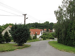
Němčice (Kolín District) is a village and municipality in Kolín District in the Central Bohemian Region of the Czech Republic.
Kolín District is a district (okres) within Central Bohemian Region of the Czech Republic. Its capital is city Kolín.
The Central Bohemian Region is an administrative unit of the Czech Republic, located in the central part of its historical region of Bohemia. Its administrative centre is in the Czech capital Prague, which lies in the centre of the region. However, the city is not part of it but is a region of its own.
The Czech Republic, also known by its short-form name, Czechia, is a landlocked country in Central Europe bordered by Germany to the west, Austria to the south, Slovakia to the east and Poland to the northeast. The Czech Republic covers an area of 78,866 square kilometres (30,450 sq mi) with a mostly temperate continental climate and oceanic climate. It is a unitary parliamentary republic, with 10.6 million inhabitants; its capital and largest city is Prague, with 1.3 million residents. Other major cities are Brno, Ostrava, Olomouc and Pilsen. The Czech Republic is a member of the European Union (EU), NATO, the OECD, the United Nations, the OSCE, and the Council of Europe.
Břežany I is a village and municipality in Kolín District in the Central Bohemian Region of the Czech Republic.
Jestřabí Lhota is a village and municipality in Kolín District in the Central Bohemian Region of the Czech Republic.
Krakovany is a village and municipality in Kolín District in the Central Bohemian Region of the Czech Republic.
Krupá is a village and municipality in Kolín District in the Central Bohemian Region of the Czech Republic.
Krychnov is a village and municipality in Kolín District in the Central Bohemian Region of the Czech Republic.
Libodřice is a village and municipality in Kolín District in the Central Bohemian Region of the Czech Republic.
Nová Ves I is a village and municipality in Kolín District in the Central Bohemian Region of the Czech Republic.
Ohaře is a village and municipality in Kolín District in the Central Bohemian Region of the Czech Republic.
Pašinka is a village and municipality in Kolín District in the Central Bohemian Region of the Czech Republic.
Pňov-Předhradí is a village and municipality in Kolín District in the Central Bohemian Region of the Czech Republic.
Polepy is a village and municipality in Kolín District in the Central Bohemian Region of the Czech Republic.
Polní Chrčice is a village and municipality in Kolín District in the Central Bohemian Region of the Czech Republic.
Polní Voděrady is a village and municipality in Kolín District in the Central Bohemian Region of the Czech Republic. It is located 8 kilometres (5.0 mi) southwest of Kolín and 49 kilometres (30 mi) east of Prague.
Radovesnice II is a village and municipality in Kolín District in the Central Bohemian Region of the Czech Republic.
Svojšice is a village and municipality in Kolín District in the Central Bohemian Region of the Czech Republic.
Tři Dvory is a village and municipality in Kolín District in the Central Bohemian Region of the Czech Republic.
Veletov is a village and municipality in Kolín District in the Central Bohemian Region of the Czech Republic.
Zalešany is a village and municipality in Kolín District in the Central Bohemian Region of the Czech Republic.
Žabonosy is a village and municipality in Kolín District in the Central Bohemian Region of the Czech Republic.
Wikimedia Commons has media related to Němčice (Kolín District) . |
Coordinates: 50°4′46″N15°18′5″E / 50.07944°N 15.30139°E
A geographic coordinate system is a coordinate system that enables every location on Earth to be specified by a set of numbers, letters or symbols. The coordinates are often chosen such that one of the numbers represents a vertical position and two or three of the numbers represent a horizontal position; alternatively, a geographic position may be expressed in a combined three-dimensional Cartesian vector. A common choice of coordinates is latitude, longitude and elevation. To specify a location on a plane requires a map projection.
This Kolín District location article is a stub. You can help Wikipedia by expanding it. |