
Waipoua Forest is a forest, on the west coast of the Northland Region of New Zealand's North Island. It preserves some of the best examples of kauri forest remaining in New Zealand. It is notable for having two of the largest living kauri trees, Tāne Mahuta and Te Matua Ngahere.
Forest & Bird, also known by its formal name as the Royal Forest and Bird Protection Society of New Zealand, is an environmental organisation specialising in the protection and conservation of New Zealand's indigenous flora and fauna and unique wild places and natural ecosystems. Forest & Bird consists of 47 branches located in urban and rural centres throughout New Zealand. Branches are actively engaged in conservation projects and advocacy on a community, regional and national basis. Forest & Bird has offices and staff located in Auckland, Christchurch, Wellington, Nelson and Dunedin. Forest & Bird publishes a quarterly magazine Forest & Bird, one of New Zealand's definitive natural history and conservation publications.
Hakarimata Range is a range of hills on the western edge of Ngāruawāhia township, in the Waikato region of New Zealand, overlooking the confluence of the Waikato and Waipā Rivers. The Hakarimata Range is separated from the Taupiri Range by the Taupiri Gorge, through which the Waikato River flows.
This is a timeline of environmental history of New Zealand. It includes notable events affecting the natural environment of New Zealand as a result of human activity.

Ōtamahua / Quail Island is an 81 ha uninhabited island within Lyttelton Harbour / Whakaraupō in the South Island of New Zealand, close to Christchurch. The island was given its European name by Captain William Mein Smith who saw native quail here in 1842; though they were already extinct by 1875. Ōtamahua means 'the place where children collect sea eggs'. Te Kawakawa refers to the pepper trees found on the island.
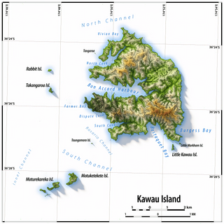
Kawau Island is in the Hauraki Gulf, close to the north-eastern coast of the North Island of New Zealand. At its closest point it lies 1.4 km (0.87 mi) off the coast of the Northland Peninsula, just south of Tāwharanui Peninsula, and about 8 km (5.0 mi) by sea journey from Sandspit Wharf, and shelters Kawau Bay to the north-east of Warkworth. It is 40 km (25 mi) north of Auckland. Mansion House in the Kawau Island Historic Reserve is an important historic tourist attraction. Almost every property on the Island relies on direct access to the sea. There are only two short roads serving settlements at Schoolhouse Bay and South Cove, and most residents have private wharves for access to their front door steps.

Zealandia, formerly known as the Karori Wildlife Sanctuary, is a protected natural area in Wellington, New Zealand, the first urban completely fenced ecosanctuary, where the biodiversity of 225 ha of forest is being restored. The sanctuary was previously part of the water catchment area for Wellington, between Wrights Hill and the Brooklyn wind turbine on Polhill.
An ecological island is a term used in New Zealand, and increasingly in Australia, to refer to an area of land isolated by natural or artificial means from the surrounding land, where a natural micro-habitat exists amidst a larger differing ecosystem. In New Zealand the term is used to refer to one of several types of nationally protected areas.

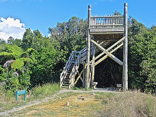
Anchor Island is an island in Dusky Sound in Fiordland.

Orokonui Ecosanctuary, called Te Korowai o Mihiwaka in Māori, is an ecological island wildlife reserve developed by the Otago Natural History Trust in the Orokonui Valley between Waitati and Pūrākaunui, New Zealand, 20 kilometres (12 mi) to the north of central Dunedin.

The whitehead is a small species of passerine bird endemic to New Zealand. It is classified in the family Mohouidae. The male whitehead's upperparts, wings and tail are a pale brown in colour, while the head and underparts are white – in the case of the male an almost pure white in colour. Females and juveniles have similar colouration except that the nape and crown are shaded brown. The black beak and eyes contrast with the white head and the feet are bluish black in colouration.

Pūkaha National Wildlife Centre is a captive breeding facility and visitor centre located in a protected forest area on State Highway 2 in New Zealand's Tararua district. It was formerly called Mount Bruce National Wildlife Centre, then Pūkaha / Mount Bruce National Wildlife Centre.

The environment of New Zealand is characterised by an endemic flora and fauna which has evolved in near isolation from the rest of the world. The main islands of New Zealand span two biomes, temperate and subtropical, complicated by large mountainous areas above the tree line. There are also numerous smaller islands which extend into the subantarctic. The prevailing weather systems bring significantly more rain to the west of the country. New Zealand's territorial waters cover a much larger area than its landmass and extend over the continental shelf and abyssal plateau in the South Pacific Ocean, Tasman Sea and Southern ocean.
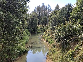
The Mangapu River is a river of the Waikato region of New Zealand's North Island. It has its sources in numerous streams which flow generally northwards from the King Country south of Te Kūiti, the longest of which is the Mangaokewa Stream. These streams join to form the Mangapu close to Te Kuiti, and from here the river flows north, passing close to the east of Waitomo Caves, where the Mangapu caves have the largest entrance in the North Island, before flowing into the Waipā River at Ōtorohanga.

Pureora Forest Park is a 760-square-kilometre (290 sq mi) protected area in the North Island of New Zealand. Within its rich rainforest are an abundance of 1,000-year-old podocarp trees. It is "recognised as one of the finest rain forests in the world". Established in 1978, after a series of protests and tree sittings, the park is one of the largest intact tracts of native forest in the North Island and has high conservation value due to the variety of plant life and animal habitats. New Zealand's largest totara tree is located nearby on private land.

Bushy Park is a native forest reserve and bird sanctuary located in the Manawatū-Whanganui region of the North Island of New Zealand. The reserve is located eight kilometres (5.0 mi) inland from Kai Iwi and has an area of approximately 99 hectares, including the Bushy Park Homestead and grounds. The forest has a diverse range of native plant species, with canopy trees including northern rātā, rimu, tawa, and pukatea. In 1962, the forest was gifted to the Royal Forest and Bird Protection Society of New Zealand by the former owner G. F. Moore, along with the homestead and its surrounds. The reserve is now managed by the Bushy Park Trust, in partnership with Forest & Bird and local iwi Ngā Rauru Kītahi. The forest reserve and homestead were renamed as Bushy Park Tarapuruhi in 2019.

Sir Tumu Te Heuheu Tūkino VIII is a New Zealand Māori tribal leader. He is the eighth elected paramount chief of the Ngāti Tūwharetoa iwi in the central North Island, and an influential figure among Māori people throughout New Zealand.
Sir Eion Sinclair Edgar was a New Zealand businessman and philanthropist. He was the chairman of Forsyth Barr Group, a major investment company based in Dunedin, for 20 years until his retirement in 2018, and was chancellor of the University of Otago between 1999 and 2003.

James Robert Lynch is a New Zealand cartoonist and conservationist. Lynch is best known as the founder of eco-sanctuary Zealandia in Wellington.
Wainuiomata Water Collection Area is a reserve located near Wainuiomata, Lower Hutt in the Wellington Region at the southern end of New Zealand's North Island. It is administered by Wellington Regional Council, for exclusive use by Wellington Water as a water catchment reserve. The park covers the catchments of the Wainuiomata River and the Ōrongorongo River. It adjoins Remutaka Forest Park and Wainuiomata Regional Park.