Prague is the capital and largest city of the Czech Republic, and the historical capital of Bohemia. On the Vltava river, Prague is home to about 1.3 million people. The city has a temperate oceanic climate, with relatively warm summers and chilly winters.

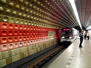
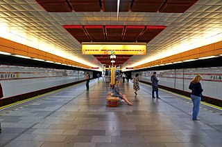
The Prague Metro is the rapid transit network of Prague, Czech Republic. Founded in 1974, the system consists of three lines serving 61 stations, and is 65.2 kilometres (40.5 mi) long. The system served 568 million passengers in 2021.

Wenceslas Square is one of the main city squares and the centre of the business and cultural communities in the New Town of Prague, Czech Republic. Many historical events occurred there, and it is a traditional setting for demonstrations, celebrations, and other public gatherings. It is also the place with the busiest pedestrian traffic in the whole country. The square is named after Saint Wenceslas, the patron saint of Bohemia. It is part of the historic centre of Prague, a World Heritage Site.

The Old Town of Prague is a medieval settlement of Prague, Czech Republic. It was separated from the outside by a semi-circular moat and wall, connected to the Vltava river at both of its ends. The moat is now covered up by the streets Revoluční, Na Příkopě, and Národní—which remain the official boundary of the cadastral community of Old Town. It is now part of Prague 1.
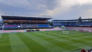
The Letná Stadium, is a football stadium in Prague. It is the home venue of AC Sparta Prague and often hosts the home matches of the Czech Republic national football team. The stadium's capacity is 18,887 seats.
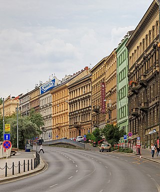
The New Town is a quarter in the city of Prague in the Czech Republic. New Town is the youngest and largest of the five independent towns that today comprise the historic center of modern Prague. New Town was founded in 1348 by Charles IV just outside the city walls to the east and south of the Old Town and encompassed an area of 7.5 km²; about three times the size of the Old Town. The population of Prague in 1378 was well over 40,000, perhaps as much as twice that, making it the 4th most populated city north of the Alps and, by area, the 3rd largest city in Europe. Although New Town can trace its current layout to its construction in the 14th century, only few churches and administrative buildings from this time survive. There are many secular and educational buildings in New Town, but also especially magnificent gothic and baroque churches. These nevertheless are not the main drawing points for tourists. New Town's most famous landmark is Wenceslas Square, which was originally built as a horsemarket and now functions as a center of commerce and tourism. In the 15th century, the Novoměstská radnice, or New Town Hall, was the site of the first of the three defenestrations of Prague.

Prague 1, formally the Prague 1 Municipal District, is a second-tier municipality in Prague. It is co-extensive with the national administrative district of the same name.

The National Museum (NM) is a Czech museum institution intended to systematically establish, prepare, and publicly exhibit natural scientific and historical collections. It was founded in 1818 by Kašpar Maria Šternberg. Historian František Palacký was also strongly involved in the foundation of the museum.
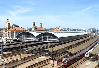
Praha hlavní nádraží is the largest railway station in Prague, Czech Republic.

Můstek is a Prague Metro station that serves as an interchange point between lines A and B, situated under the lower end of Wenceslas Square. Each line has a separate set of platforms which are connected by a series of corridors. After the excavation of the area, a medieval bridge was discovered and the meaning of the area name Můstek was fully understood.
Palmovka is a Prague Metro station on Line B and also a neighborhood and a street in Libeň. The western metro entrance connects the station with the tram lines; the eastern one connects the station to a bus terminal.

The Prague tramway network is the largest tram network in the Czech Republic, consisting of 144 km (89 mi) of track, 882 tram vehicles and 26 daytime routes, 2 historical and 10 night routes with a total route length of 518 km (322 mi). It is operated by Dopravní podnik hlavního města Prahy a.s., a company owned by the city of Prague. The network is a part of Prague Integrated Transport, the city's integrated public transport system.

Fortuna Arena is a football stadium, in Prague-Vršovice, Czech Republic. The stadium has a capacity of 19,370 people and it is the biggest and the most modern football stadium in the Czech Republic.

Postal codes in the Czech Republic are called PSČ. The acronym is commonly pronounced as a word, rather than separate letters. The system was introduced in former Czechoslovakia in 1973 and has remained unchanged. The postal code consists of five digits, usually written with a space in the form XXX XX. The first digit indicates a region :

Strašnice is a cadastral district in Prague. It became part of Prague on 1 January 1922. It lies mostly in the municipal and administrative district of Prague 10 while a small part is in Prague 3. The district is bordered by Vršovice, Vinohrady, Žižkov, Malešice, Hostivař, Záběhlice and Michle.

Náměstí Republiky is a city square in Prague, Czech Republic, lying at the boundary of the Old Town and New Town. On the square, or in the very near vicinity, are these significant buildings: Kotva Department Store, Municipal House, Powder Tower, Czech National Bank and Palladium shopping mall. From the square leads Na příkopě street, the most expensive street among the all states of the V4, connecting it with the Wenceslas Square.
Komořany is a former village which is now a cadastral subdivision of the municipal district of Prague 12.

Bílá labuť is a department store on Na Poříčí Street in central Prague, Czech Republic. It is considered to be one of the finest examples of interwar avant-garde architecture. It is recognised by the Prague Municipality as an architecturally valuable building and is protected as a cultural real estate monument. At the time it was opened in 1939, it was the biggest and most modern department store in Central and Eastern Europe. It is currently undergoing extensive renovation.

The following outline is provided as an overview of and topical guide to Prague: