The Marshall Islands, officially the Republic of the Marshall Islands, is an island country west of the International Date Line and north of the equator in the Micronesia region of the Northwestern Pacific Ocean.

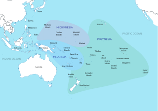
Micronesia is a subregion of Oceania, consisting of approximately 2,000 small islands in the Northwestern Pacific Ocean. It has a close shared cultural history with three other island regions: Maritime Southeast Asia to the west, Polynesia to the east, and Melanesia to the south—as well as with the wider community of Austronesian peoples.

Bikini Atoll, known as Eschscholtz Atoll between the 19th century and 1946, is a coral reef in the Marshall Islands consisting of 23 islands surrounding a 229.4-square-mile (594.1 km2) central lagoon. The atoll is at the northern end of the Ralik Chain, approximately 530 miles (850 km) northwest of the capital Majuro.

Sea monsters are beings from folklore believed to dwell in the sea and are often imagined to be of immense size. Marine monsters can take many forms, including sea dragons, sea serpents, or tentacled beasts. They can be slimy and scaly and are often pictured threatening ships or spouting jets of water. The definition of a "monster" is subjective; further, some sea monsters may have been based on scientifically accepted creatures, such as whales and types of giant and colossal squid.

The Kon-Tiki expedition was a 1947 journey by raft across the Pacific Ocean from South America to the Polynesian islands, led by Norwegian explorer and writer Thor Heyerdahl. The raft was named Kon-Tiki after the Inca god Viracocha, for whom "Kon-Tiki" was said to be an old name. Heyerdal's book on the expedition was entitled The Kon-Tiki Expedition: By Raft Across the South Seas. A 1950 documentary film won the Academy Award for Best Documentary Feature. A 2012 dramatized feature film was nominated for the Academy Award for Best Foreign Language Film.

Tabuaeran, also known as Fanning Island, is an atoll that is part of the Line Islands of the central Pacific Ocean and part of the island nation of Kiribati. The land area is 33.73 square kilometres, and the population in 2015 was 2,315. The maximum elevation is about 3 m (10 ft) above high tide.

Necker Island is a small island in the Northwestern Hawaiian Islands. It is located at 23°34′30″N164°42′01″W in the Pacific Ocean, 430 miles northwest of Honolulu, Hawaii, 155 miles northwest of Nihoa, and 8 miles north of the Tropic of Cancer. It is part of the state of Hawaii in the United States. It contains important prehistoric archaeological sites of the Hawaiian culture and is part of the Hawaiian Islands National Wildlife Refuge within the Papahānaumokuākea Marine National Monument.

Hōkūleʻa is a performance-accurate waʻa kaulua, a Polynesian double-hulled voyaging canoe. Launched on 8 March 1975 by the Polynesian Voyaging Society, it is best known for its 1976 Hawaiʻi to Tahiti voyage completed with exclusively traditional navigation techniques. The primary goal of the voyage was to explore the anthropological theory of the Asiatic origin of native Oceanic people as the result of purposeful trips through the Pacific, as opposed to passive drifting on currents or sailing from the Americas. DNA analysis supports this theory. A secondary project goal was to have the canoe and voyage "serve as vehicles for the cultural revitalization of Hawaiians and other Polynesians."
Hawaiʻiloa is a mythical Hawaiian fisherman and navigator who is said to have discovered the island of Hawaiʻi.

Tikopia is a volcanic island in Temotu Province, in the independent nation of Solomon Islands, southwestern Pacific Ocean. Although most of Solomon Islands is Melanesian, Tikopia is culturally Polynesian. The first Europeans arrived on 22 April 1606 as part of the Spanish expedition of Pedro Fernandes de Queirós.

Pius "Mau" Piailug was a Micronesian navigator from the Carolinian island of Satawal, best known as a teacher of traditional, non-instrument wayfinding methods for open-ocean voyaging. Mau's Carolinian navigation system, which relies on navigational clues using the Sun and stars, winds and clouds, seas and swells, and birds and fish, was acquired through rote learning passed down through teachings in the oral tradition. He earned the title of master navigator (palu) by the age of eighteen, around the time the first American missionaries arrived in Satawal. As he neared middle age, Mau grew concerned that the practice of navigation in Satawal would disappear as his people became acculturated to Western values. In the hope that the navigational tradition would be preserved for future generations, Mau shared his knowledge with the Polynesian Voyaging Society (PVS). With Mau's help, PVS used experimental archaeology to recreate and test lost Hawaiian navigational techniques on the Hōkūleʻa, a modern reconstruction of a double-hulled Hawaiian voyaging canoe.

The Coastwatchers, also known as the Coast Watch Organisation, Combined Field Intelligence Service or Section C, Allied Intelligence Bureau, were Allied military intelligence operatives stationed on remote Pacific islands during World War II to observe enemy movements and rescue stranded Allied personnel. They played a significant role in the Pacific Ocean theatre and South West Pacific theatre, particularly as an early warning network during the Guadalcanal campaign.

Call It Courage is a 1940 children's novel written and illustrated by American author Armstrong Sperry. The novel won the Newbery Medal for excellence in American children's literature in 1941.

Between 1492 and 1504, the Italian navigator and explorer Christopher Columbus led four transatlantic maritime expeditions in the name of the Catholic Monarchs of Spain to the Caribbean and to Central and South America. These voyages led to the widespread knowledge of the New World. This breakthrough inaugurated the period known as the Age of Discovery, which saw the colonization of the Americas, a related biological exchange, and trans-Atlantic trade. These events, the effects and consequences of which persist to the present, are often cited as the beginning of the modern era.

Polynesian navigation or Polynesian wayfinding was used for thousands of years to enable long voyages across thousands of kilometres of the open Pacific Ocean. Polynesians made contact with nearly every island within the vast Polynesian Triangle, using outrigger canoes or double-hulled canoes. The double-hulled canoes were two large hulls, equal in length, and lashed side by side. The space between the paralleled canoes allowed for storage of food, hunting materials, and nets when embarking on long voyages. Polynesian navigators used wayfinding techniques such as the navigation by the stars, and observations of birds, ocean swells, and wind patterns, and relied on a large body of knowledge from oral tradition. This island hopping was a solution to the scarcity of useful resources, such as food, wood, water, and available land, on the small islands in the Pacific Ocean. When an island’s required resources for human survival began to run low, the island's inhabitants used their maritime navigation skills and set sail for new islands. However, as an increasing number of islands in the South Pacific became occupied, and citizenship and national borders became of international importance, this was no longer possible. People thus became trapped on islands with the inability to support them.

Polynesia is a subregion of Oceania, made up of more than 1,000 islands scattered over the central and southern Pacific Ocean. The indigenous people who inhabit the islands of Polynesia are called Polynesians. They have many things in common, including linguistic relations, cultural practices, and traditional beliefs. In centuries past, they had a strong shared tradition of sailing and using stars to navigate at night.

North Carolina Aquariums is a system of three public aquariums located in Kure Beach, Roanoke Island and Pine Knoll Shores. All are operated by the Aquariums Division of the North Carolina Department of Natural and Cultural Resources since 1976 and were accredited by the Association of Zoos and Aquariums. All three aquariums feature dive shows, live animal encounters, and feeding programs.

The Japanese occupation of Nauru was the period of three years during which Nauru, a Pacific island which at that time was under Australian administration, was occupied by the Japanese military as part of its operations in the Pacific War during World War II. With the onset of the war, the islands that flanked Japan's South Seas possessions became of vital concern to Japanese Imperial General Headquarters, and in particular to the Imperial Navy, which was tasked with protecting Japan's outlying Pacific territories.

Wa are traditional sailing outrigger canoes of the Caroline Islands, which also includes Palau and Yap. They have a single outrigger. They are similar to the sakman of the Northern Marianas.

US FWS Charles H. Gilbert was an American fisheries science research vessel in commission from 1952 to 1970 in the fleet of the United States Department of the Interior's Fish and Wildlife Service and from 1970 to 1973 in the fleet of the National Oceanic Atmospheric Administration as NOAAS Charles H. Gilbert. She was among the first U.S. fisheries science vessels to explore the central Pacific Ocean in search of commercially valuable populations of fish.


