Nakadori Island

Last updated

Coordinates: 32°59′N129°05′E / 32.983°N 129.083°E / 32.983; 129.083

Geographic coordinate system Coordinate system

A geographic coordinate system is a coordinate system that enables every location on Earth to be specified by a set of numbers, letters or symbols. The coordinates are often chosen such that one of the numbers represents a vertical position and two or three of the numbers represent a horizontal position; alternatively, a geographic position may be expressed in a combined three-dimensional Cartesian vector. A common choice of coordinates is latitude, longitude and elevation. To specify a location on a plane requires a map projection.

Contents

Nakadōri Island
中通島
Map-GotoRetto-en.png
Location of Nakadōri Island (Nakadōri-jima) in the Gotō Islands
Japan location map with side map of the Ryukyu Islands.svg
Red pog.svg
Nakadōri Island
Geography
Location East China Sea
Archipelago Gotō Islands
Administration
Japan
Prefecture Nagasaki

Nakadōri Island [1] (中通島,Nakadōri-jima) is an island in the Gotō Islands, Japanese islands in the East China Sea, off the western coast of Kyūshū. The islands are a part of Nagasaki Prefecture in Japan.

Gotō Islands Japanese islands

The Gotō Islands are Japanese islands in the East China Sea, off the western coast of Kyūshū. They are part of Nagasaki Prefecture.

East China Sea A marginal sea of the Pacific Ocean between the south of Korea, the south of Kyushu, Japan, the Ryukyu islands and mainland China

The East China Sea is a marginal sea east of China. The East China Sea is a part of the Pacific Ocean and covers an area of roughly 1,249,000 square kilometres (482,000 sq mi). To the east lies the Japanese island of Kyushu and the Ryukyu Islands, to the south, lies the South China Sea, and to the west by the Asian continent. The sea connects with the Sea of Japan through the Korea Strait and opens to the north into the Yellow Sea. The countries which border the sea include Japan, Taiwan and China.

Nagasaki Prefecture Prefecture of Japan

Nagasaki Prefecture is a prefecture of Japan located on the island of Kyushu. The capital is the city of Nagasaki.

Geography

The island is roughly the same shape as a left hand held with the thumb and index finger extended. Thus, it is relatively long, narrow, and very mountainous. The roads are quite narrow and very curvy.

History

The island has been subject to two distinct periods of prosperity. These were the era of active trade with China until the 13th century and a more recent whaling boom that lasted until about fifty years ago[ citation needed ]. Both of these periods made this small rural area quite famous throughout Japan. The island has many interesting artifacts from both of these periods.

China Country in East Asia

China, officially the People's Republic of China (PRC), is a country in East Asia and the world's most populous country, with a population of around 1.404 billion. Covering approximately 9,600,000 square kilometers (3,700,000 sq mi), it is the third- or fourth-largest country by total area. Governed by the Communist Party of China, the state exercises jurisdiction over 22 provinces, five autonomous regions, four direct-controlled municipalities, and the special administrative regions of Hong Kong and Macau.

Whaling hunting of whales

Whaling is the hunting of whales for their usable products such as meat and blubber, which can be turned into a type of oil which became increasingly important in the Industrial Revolution. It was practiced as an organized industry as early as 875 AD. By the 16th century, it had risen to be the principle industry in the coastal regions of Spain and France. The industry spread throughout the world, and became increasingly profitable in terms of trade and resources. Some regions of the world's oceans, along the animals' migration routes, had a particularly dense whale population, and became the targets for large concentrations of whaling ships, and the industry continued to grow well into the 20th century. The depletion of some whale species to near extinction led to the banning of whaling in many countries by 1969, and to a worldwide cessation of whaling as an industry in the late 1980s. The earliest forms of whaling date to at least circa 3000 BC. Coastal communities around the world have long histories of subsistence use of cetaceans, by dolphin drive hunting and by harvesting drift whales. Industrial whaling emerged with organized fleets of whaleships in the 17th century; competitive national whaling industries in the 18th and 19th centuries; and the introduction of factory ships along with the concept of whale harvesting in the first half of the 20th century. By the late 1930s more than 50,000 whales were killed annually. In 1986, the International Whaling Commission (IWC) banned commercial whaling because of the extreme depletion of most of the whale stocks.

In August 2004, the five towns: Kamigotō, Shin-Uonome, Arikawa, Narao, Wakamatsu merged into a new town, appropriately named Shin-Kamigotō (shin means "new").

See also

Sources

Related Research Articles

Dejima former artificial island in Nagasaki

Dejima was a Dutch trading post located in Nagasaki, Japan from 1641 to 1854.

Saga Prefecture Prefecture of Japan

Saga Prefecture is a prefecture in the northwest part of the island of Kyushu, Japan. It touches both the Sea of Japan and the Ariake Sea. The western part of the prefecture is a region famous for producing ceramics and porcelain, particularly the towns of Karatsu, Imari, and Arita. The capital is the city of Saga.

Fukue was a city located in the Gotō Islands of Nagasaki Prefecture, Japan. It was the largest city on the Gotō Islands. The city was founded on April 1, 1954.

Tsushima, Nagasaki City in Kyushu, Japan

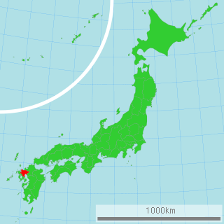
Tsushima is an island city grouped in Nagasaki Prefecture, Japan. It is the only city of Tsushima Subprefecture and it encompasses all of Tsushima Island Archipelago, which lies in the Tsushima Strait north of Nagasaki on the western side of Kyushu, the southernmost mainland island of Japan.

Tsushima Strait eastern channel of the Korea Strait

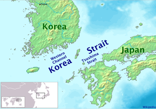
Tsushima Strait or Eastern Channel is a channel of the Korea Strait, which lies between Korea and Japan, connecting the Sea of Japan, the Yellow Sea, and the East China Sea.

Iōjima, Nagasaki human settlement in Japan

Iōjima was a town located in Nishisonogi District, Nagasaki Prefecture, Japan. Iōjima was the only town on the island of Iōjima near Nagasaki City. The island includes beaches and an onsen.

Gotō, Nagasaki City in Kyushu, Japan

Gotō is a city in Nagasaki Prefecture, Japan. It comprises the south-west half of the Gotō Islands plus (uninhabited) Danjo and Hizen Torishima archipelagos in the East China Sea. Although the core islands of the city lay some 100 kilometers from Nagasaki, the other archipelagos lay 60 km further to South-West. The city consists of 11 inhabited and 52 uninhabited islands. The three main islands of the city are Fukue, Hisaka, and Naru.

Hashima Island Abandoned island lying about 15 kilometres (9 miles) from the city of Nagasaki, in southern Japan

Hashima Island, commonly called Gunkanjima, is an abandoned island lying about 15 kilometers (9 miles) from the city of Nagasaki, in southern Japan. It is one of 505 uninhabited islands in Nagasaki Prefecture. The island's most notable features are its abandoned concrete buildings, undisturbed except by nature, and the surrounding sea wall. While the island is a symbol of the rapid industrialization of Japan, it is also a reminder of its history as a site of forced labor prior to and during the Second World War.

Minami-Matsuura District, Nagasaki Japanese district

Minami-Matsuura is a district located in Nagasaki Prefecture, Japan.

Shin-Kamigotō Town in Kyushu, Japan

Shin-Kamigotō is a town located in Minami-Matsuura District, Nagasaki Prefecture, Japan.

Nagasaki Chinatown shopping strip in Nagasaki

Nagasaki Chinatown is an area located in Nagasaki, Nagasaki, Japan. Today this area is a shopping strip covering many blocks.

Fukue Island island in Gotō Islands, Nagasaki, Japan

Fukue Island is the largest and southernmost of the Gotō Islands in Japan. It is part of the city of Gotō in Nagasaki Prefecture. Gotō-Fukue Airport is on this island.

Hisaka Island island in Nagasaki, Japan

Hisaka Island is one of the Gotō Islands in Japan. The island is part of the city of Gotō in the Nagasaki Prefecture.

Naru Island island in Gotō Islands, Nagasaki, Japan

Naru Island is one of the Gotō Islands in Japan. It is part of the city of Gotō in Nagasaki Prefecture.

Wakamatsu Island island in Nagasaki, Japan

Wakamatsu Island is one of the Gotō Islands in Japan. The island is part of the town of Shin-Kamigotō in Nagasaki Prefecture.

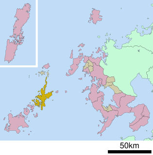
Nagasaki 3rd district is a single-member electoral district for the House of Representatives, the lower house of the National Diet of Japan. It is located in the prefecture of Nagasaki. It covers parts of Nagasaki on the main island of Kyūshū – the city of Ōmura and the towns of Kawatana, Hasami and Higashisonogi, Nagasaki in former Higashi-Sonogi-gun – and several of the prefecture's island municipalities: the cities of Iki, Tsushima and Gotō and the town of Shin-Kamigotō in Minami-Matsuura/"South Matsuura" district. As of September 2011, 211,289 eligible voters were registered in Nagasaki 3rd district, giving it the second highest vote weight in the country.

Kabajima (椛島), also known as Kabashima, is a Japanese island off the southern coast of Nagasaki Prefecture off the island of Kyushu.

References

  1. "Nagasaki, Unzen, Goto Islands, Iki and Tsushima" (PDF). Japan National Tourist Organization. 2007.