Related Research Articles

The Rocky Mountains, also known as the Rockies, are a major mountain range and the largest mountain system in North America. The Rocky Mountains stretch 3,000 mi (4,800 km) in straight-line distance from the northernmost part of western Canada, to New Mexico in the southwestern United States. Depending on differing definitions between Canada and the United States, its northern terminus is located either in northern British Columbia's Terminal Range south of the Liard River and east of the Trench, or in the northeastern foothills of the Brooks Range/British Mountains that face the Beaufort Sea coasts between the Canning River and the Firth River across the Alaska-Yukon border. Its southernmost point is near the Albuquerque area adjacent to the Rio Grande Basin and north of the Sandia–Manzano Mountain Range. Being the easternmost portion of the North American Cordillera, the Rockies are distinct from the tectonically younger Cascade Range and Sierra Nevada, which both lie farther to its west.
Banff National Park is Canada's oldest national park, established in 1885. Located in Alberta's Rocky Mountains, 110–180 kilometres (68–112 mi) west of Calgary, Banff encompasses 6,641 square kilometres (2,564 sq mi) of mountainous terrain, with many glaciers and ice fields, dense coniferous forest, and alpine landscapes. The Icefields Parkway extends from Lake Louise, connecting to Jasper National Park in the north. Provincial forests and Yoho National Park are neighbours to the west, while Kootenay National Park is located to the south and Kananaskis Country to the southeast. The main commercial centre of the park is the town of Banff, in the Bow River valley.

Glacier National Park is an American national park located in northwestern Montana, on the Canada–United States border, adjacent to the Canadian provinces of Alberta and British Columbia. The park encompasses more than 1 million acres (4,000 km2) and includes parts of two mountain ranges, more than 130 named lakes, more than 1,000 different species of plants, and hundreds of species of animals. This vast pristine ecosystem is the centerpiece of what has been referred to as the "Crown of the Continent Ecosystem," a region of protected land encompassing 16,000 square miles (41,000 km2).

Waterton Lakes National Park is a national park located in the southwest corner of Alberta, Canada. It borders Glacier National Park in Montana, United States. Waterton was the fourth Canadian national park, formed in 1895 and named after Waterton Lake, in turn after the Victorian naturalist and conservationist Charles Waterton. Its range is between the Rocky Mountains and prairies. This park contains 505 km2 (195 sq mi) of rugged mountains and wilderness.

The Columbia Icefield is the largest ice field in North America's Rocky Mountains. Located within the Canadian Rocky Mountains astride the Continental Divide along the border of British Columbia and Alberta, Canada, the ice field lies partly in the northwestern tip of Banff National Park and partly in the southern end of Jasper National Park. It is about 325 square kilometres (125 sq mi) in area, 100 metres (330 ft) to 365 metres (1,198 ft) in depth and receives up to 7 metres (280 in) of snowfall per year.

Axel Heiberg Island is an uninhabited island in the Qikiqtaaluk Region, Nunavut, Canada. Located in the Arctic Ocean, it is the 32nd largest island in the world and Canada's seventh largest island. According to Statistics Canada, it has an area of 43,178 km2 (16,671 sq mi). It is named after Axel Heiberg.

Mount Revelstoke National Park is located adjacent to the city of Revelstoke, British Columbia, Canada. The park is relatively small for a national park, covering 260 km2 (100 sq mi). It is located in the Selkirk Mountains and was founded in 1914. Approximately 600,000 visitors enter Mount Revelstoke and nearby Glacier National Park each year.

Glacier National Park is part of a system of 43 parks and park reserves across Canada, and one of seven national parks in British Columbia. Established in 1886, the park encompasses 1,349 km2 (521 sq mi), and includes a portion of the Selkirk Mountains which are part of the larger grouping of mountains, the Columbia Mountains. It also contains the Rogers Pass National Historic Site.

Hamber Provincial Park is a provincial park in British Columbia, Canada, located at the provincial boundary with Alberta, surrounded on three sides by Jasper National Park. When the park was created in 1941, it constituted one of the largest protected wilderness areas in Canada. In the early 1960s, the provincial government reduced its size by 98% due to pressure exerted by the forestry industry, planned hydroelectric developments along the upper Columbia River and the re-routing of the Trans-Canada Highway away from the park.

The Athabasca Glacier is one of the six principal 'toes' of the Columbia Icefield, located in the Canadian Rockies. The glacier currently loses depth at a rate of about 5 metres (16 ft) per year and has receded more than 1.5 km (0.93 mi) and lost over half of its volume in the past 125 years. Easily accessible, it is the most visited glacier in North America. The leading edge of the glacier is within easy walking distance; however, travel onto the glacier is not recommended unless properly equipped. Hidden crevasses have led to the deaths of unprepared tourists.

The Waputik Icefield is located on the Continental divide in the Canadian Rocky Mountains, in the provinces of British Columbia and Alberta. It is developed on the heights of the Waputik Range in the Central Main Ranges.

The Cave and Basin National Historic Site of Canada is located in the town of Banff, Alberta, within the Canadian Rocky Mountains, at the site of natural thermal mineral springs around which Canada's first national park, Banff National Park, was established.

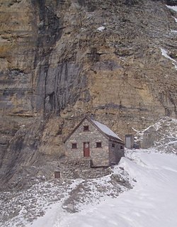
The Arthur O. Wheeler hut is an alpine hut located four km southwest of Rogers Pass in Glacier National Park, British Columbia. Although not truly a backcountry hut, this log cabin is situated conveniently close to the Trans-Canada Highway in the Selkirk Mountains, west of the Rocky Mountains. It is often used as a base for mountaineering, hiking, and ski touring into the Asulkan Range and Illecillewaet Glacier areas south of the highway, and the Hermit Range north of the highway. The hut is maintained by the Alpine Club of Canada (ACC). It is the only ACC hut which can be reached by vehicle.
The Abbot Pass hut is an alpine hut located at an altitude of 2,925 metres (9,596 ft) in Abbot Pass in the Rocky Mountains in Alberta, Canada. It is nestled between Mount Victoria and Mount Lefroy, straddling the continental divide, which, in this region, defines the boundary between Banff National Park in Alberta and Yoho National Park in British Columbia. While close to the border, the hut lies entirely in Banff National Park, and is the second-highest permanently habitable structure in Canada. The hut is maintained by the Alpine Club of Canada.

National Park Service rustic – sometimes colloquially called Parkitecture – is a style of architecture that developed in the early and middle 20th century in the United States National Park Service (NPS) through its efforts to create buildings that harmonized with the natural environment. Since its founding in 1916, the NPS sought to design and build visitor facilities without visually interrupting the natural or historic surroundings. The early results were characterized by intensive use of hand labor and a rejection of the regularity and symmetry of the industrial world, reflecting connections with the Arts and Crafts movement and American Picturesque architecture. Architects, landscape architects and engineers combined native wood and stone with convincingly native styles to create visually appealing structures that seemed to fit naturally within the majestic landscapes. Examples of the style can be found in numerous types of National Park structures, including entrance gateways, hotels and lodges, park roads and bridges, visitor centers, trail shelters, informational kiosks, and even mundane maintenance and support facilities. Many of these buildings are listed on the National Register of Historic Places.

Alberta's Rockies comprise the Canadian Rocky Mountains in Alberta, Canada. On the southwestern part of the province along the British Columbia border, the region covers all but the south of Census Division 15.

The Franklin Glacier Complex is a deeply eroded volcano in the Waddington Range of southwestern British Columbia, Canada. Located about 65 km (40 mi) northeast of Kingcome, this sketchily known complex resides at Franklin Glacier near Mount Waddington. It is over 2,000 m (6,600 ft) in elevation and because of its considerable overall altitude, a large proportion of the complex is covered by glacial ice.

Ainsworth Hot Springs, previously named Ainsworth, is a historic village on Kootenay Lake in British Columbia, Canada and has a population of 20. Founded on May 31, 1883, it is the oldest surviving community on Kootenay Lake. Ainsworth Hot Springs is located on Highway 31, 11 miles (18 km) north of Balfour and 12 miles (19 km) south of Kaslo, British Columbia. Today, Ainsworth Hot Springs and the Cody Caves are a popular destination for tourists and spelunkers.
The Twin Falls Tea House National Historic Site of Canada, located in Yoho National Park, British Columbia as a resting place for hikers and trail riders in the park. The rustic structure is located near Twin Falls in the Little Yoho Valley. The first phase of construction took place about 1908. A separate two-story cabin was built adjoining the original cabin about 1923, and the two structures were linked between 1925 and 1928. Proposed for demolition in 1969, the Tea House was designated a National Historic Site of Canada in 1992, and was extensively renovated in 2005.

The Illecillewaet Glacier is a glacier in British Columbia, Canada. It is located inside Glacier National Park in the Selkirk Mountains, a sub-range of the Columbia Mountains. After the construction of the Canadian Pacific Railway (CPR) near the glacier’s terminus, and the building of a hotel nearby, the glacier became a prominent tourist destination in the Canadian west. Easily accessible by road and railway, it is one of the most-studied glaciers in North America. Its retreat over the last one hundred years has been extensively documented.
References
- 1 2 Morris, Michael. "Nakimu Caves". National Park Feature Articles. Columbia Mountains Institute of Applied Ecology. Retrieved 27 April 2013.
- ↑ Rollins, Jon (2004). Caves of the Canadian Rockies & the Columbian Mountains. Nanoose Bay, BC: Heritage House. pp. 288–289. ISBN 9780921102946.
- ↑ Horne, Greg (September 2005). "Cave Management Guidelines for western mountain national parks of Canada" (PDF).
- ↑ Goodchild, MF; Ford, DC (January 1971). "Analysis of Scallop Patterns by Simulation Under Controlled Conditions". Journal of Geology. 79 (1): 52–62. doi:10.1086/627586. S2CID 129432271.