Naldurg

Last updated

Naldurg
town
HulmukhDarwaza1.jpg
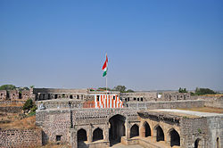
Hulmukh Darwaza, Naldurg fort
India Maharashtra location map.svg
Red pog.svg
Naldurg
Location in Maharashtra, India
Coordinates: 17°49′N76°18′E / 17.82°N 76.3°E / 17.82; 76.3
CountryFlag of India.svg  India
State Maharashtra
District dharashiv
Elevation
566 m (1,857 ft)
Population
 (2011)
  Total18,341 [1]
Languages
  Official Marathi
Time zone UTC+5:30 (IST)
Sex ratio 52%/48% /

Naldurg is a town and a municipal council in Dharashiv district in the Indian state of Maharashtra.

Contents

Geography

Naldurg is located at 17°49′N76°18′E / 17.82°N 76.3°E / 17.82; 76.3 , 438 km from Mumbai.50 km from Solapur city [2] It has an area of 7550 km2 and average elevation of 566 metres (1856 feet). The temperature ranges from 10.1 °C to 43.1 °C, and the average yearly rainfall is 760mm.

Demographics

As of 2011 India census, [3] Naldurg had a population of 18,341. Males constitute 52% of the population and females 48%. Naldurg has an average literacy rate of 84.10%, higher than the state average of 82.34%. Male literacy is 90%, and female literacy is 78%. In Naldurg, 15% of the population is under 6 years of age. [1] Schedule Caste (SC) constitutes 11.61% while Schedule Tribe (ST) were 0.95% of total population in Naldurg. [1]

See also

Related Research Articles

Barwani or Badwani is a municipal town in Barwani district of Madhya Pradesh, India, that is situated near the left bank of the Narmada River. It is the administrative headquarters of Barwani district and has also served as the capital of the former princely state of Barwani. Barwani is only accessible by road.

<span class="mw-page-title-main">Nongpoh</span> Town in Meghalaya, India

Nongpoh is the administrative centre of Ri-Bhoi district in the Indian state of Meghalaya in the Republic of India. Nongpoh is located on National Highway 40, fifty-two kilometers from the state capital Shillong and forty-eight kilometers from Guwahati in the state of Assam.

Khagaria is a town in Indian state of Bihar and the administrative headquarters of Khagaria district. Khagaria is a part of Munger division. It is located at 25.5°N 86.48°E and has an average elevation of 36 metres (118 feet). The Khagaria Junction railway station serves the town.It is situated about 25 km north of Munger.

<span class="mw-page-title-main">Gyanpur</span> City in Uttar Pradesh, India

Gyanpur is a town and a nagar panchayat in Bhadohi district in the Indian state of Uttar Pradesh.

Hamirpur is a town and a municipal board in Hamirpur district in the Indian state of Uttar Pradesh. Located just above the confluence of the Yamuna and Betwa rivers, it is the administrative headquarters of Hamirpur district.

<span class="mw-page-title-main">Baran district</span> District in Rajasthan, India

Baran district is a district in the Indian state of Rajasthan. The headquarters of the district are located at the city of Baran.

Tuljapur is a town with a municipal council in Dharashiv district in the Indian state of Maharashtra. It is the administrative seat of Tuljapur taluka.

<span class="mw-page-title-main">Bhongir</span> City in Telangana, India

Bhongir, officially known as Bhuvanagiri, is a city and a district headquarters of the Yadadri Bhuvanagiri district and part of the Hyderabad Metropolitan Region of the Indian state of Telangana.

Basna is a town in Mahasamund district in the Chhattisgarh state of India.

Etmadpur is a town (tehsil) in Agra district in the state of Uttar Pradesh, India. It is located eastward 19 km from Agra. It is 274 km far from state capital Lucknow.

Kachhwa is a town and a nagar panchayat in Mirzapur district in the Indian state of Uttar Pradesh.

<span class="mw-page-title-main">Kadipur</span> Town in Uttar Pradesh, India

Kadipur is a town, tehsil and a nagar panchayat in Sultanpur district in the Indian state of Uttar Pradesh. It is located a short distance from the bank of the Gomti River, at a crossroads between two roads heading from Sultanpur to Surapur and from Pratapgarh to Dostpur and then on to Akbarpur. On the north side of town is a stream with a steep ravine that drains the surrounding area. The road to Sultanpur crosses over this stream on a bridge. The lands surrounding Kadipur are average quality for agricultural purposes. As of 2011, Kadipur has a population of 8,010 people, in 1,216 households.

Kiraoli is a town and a nagar panchayat in Agra district in the Indian state of Uttar Pradesh.

Kishangarh Bas is a census town in Alwar district in the Indian state of Rajasthan. The Fort was built by Maharaja Surajmal. Kishan Singh who was an officer of Maharaja Surajmal of Bharatpur built the Kisheneshwar Temple inside the Fort.

Machalpur is a town and a nagar parishad in Rajgarh district in the Indian state of Madhya Pradesh.

Mhowgaon is a Nagar Panchayat under Sub Division Dr. Ambedkar Nagar (Mhow) in Indore district in the Indian state of Madhya Pradesh. The total geographical area of Mhowgaon nagar panchayat is 13.5 km2 and it is the smallest city by area in the sub district. The population density of the city is 2309 persons per km2. Mhowgaon is divided into 15 wards for which elections are held every 5 years. Among them, Mhowgaon Ward No. 2 is the most populous ward with a population of 3440 and Mhowgaon Ward No. 15 is the least populous ward with a population of 957. Mhowgaon Nagar Panchayat has total administration over 6,373 houses to which it supplies basic amenities like water and sewerage. It is also authorized to build roads within Nagar Panchayat limits and impose taxes on properties coming under its jurisdiction.

Sarjamda is a census town in the Golmuri-cum-Jugsalai CD block in the Dhalbhum subdivision of the Purbi Singhbhum district in the Indian state of Jharkhand.

<span class="mw-page-title-main">Usilampatti</span> Town in Tamil Nadu, India

Usilampatti is a town and a second grade municipality in the Indian state of Tamil Nadu. It is also a designated taluk and revenue division.

<span class="mw-page-title-main">Dewa, India</span> Town in Uttar Pradesh, India

Dewa Sharif or Dewa is a town and a nagar panchayat in Barabanki district in the state of Uttar Pradesh, India. It is famous for the shrine of Haji Waris Ali Shah. This town is also known by the name of Dewa Sharif in respect for the shrine. It is about 26 km north-east of the capital Lucknow.

<span class="mw-page-title-main">Yachenahalli</span> Village in Karnataka, India

Yachenahalli is a panchayat town in Mysore district in the state of Karnataka, India. It is located 35 km from Mysore and 17 km from Mandya. The nearest city is Bannur with 10 km distance.

References

  1. 1 2 3 "Naldurg City Population". census 2011. Retrieved 19 July 2015.
  2. Falling Rain Genomics, Inc – Naldurg
  3. "Census of India 2001: Data from the 2001 Census, including cities, villages and towns (Provisional)". Census Commission of India. Archived from the original on 16 June 2004. Retrieved 1 November 2008.