Nam Tok Sai Yok Noi

Last updated • 1 min readFrom Wikipedia, The Free Encyclopedia
Nam Tok Sai Yok Noi
น้ำตกไทรโยคน้อย
Tarsoa
Small town
Nam Tok Sai Yok Noi Railway Station.JPG
Thailand adm location map.svg
Red pog.svg
Nam Tok Sai Yok Noi
Location in Thailand
Coordinates: 14°14′14″N99°4′2″E / 14.23722°N 99.06722°E / 14.23722; 99.06722
CountryThailand
Province Kanchanaburi Province
District Sai Yok District
Area
  Total4.4 km2 (1.7 sq mi)
Population
 (2012) [1]
  Total3,675
  Density840/km2 (2,200/sq mi)
Time zone UTC+7 (ICT)

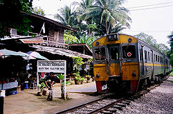
Nam Tok Sai Yok Noi (Thai : น้ำตกไทรโยคน้อย, lit. 'small Sai Yok waterfall') is a small town ( thesaban tambon ) in Sai Yok District, Kanchanaburi Province, Thailand, along the route of the Death Railway linking Thailand with Burma. It is named after Sai Yok Noi Waterfall of Sai Yok National Park. During World War II, the small town was known as Tarsoa or Tarsau. [2]

Contents

History

The sanitary district ( sukhaphiban ) was created in 1971. [3] It was upgraded to a township ( thesaban tambon ) in May 1999, when all of the sanitary districts were upgraded. As of 2012, the town had a population of 3,675, [1] and covered an area of 4.4 km2 of subdistrict ( tambon ) Tha Sao.

Camp Tarsoa

Camp Tarsoa was a large Japanese prisoner of war camp constructed during World War II. It consisted of a transit camp, a work camp and a hospital camp, and was founded on 24 January 1943. [4] The work camp originally contained 400 prisoners, but was enlarged to 800 prisoners. [5] The hospital had a very bad reputation and hardly any medical supplies. [6] There were three large cemeteries near the camp, one of which was for deaths from cholera. [5] The camps closed in April 1944. [4]

Australian prisoners of war veterans erected a memorial at Hellfire Pass, and each year on 25 April, there is a memorial ceremony. [7] Hellfire Pass is located 27 kilometres (17 mi) from Nam Tok. [8]

Related Research Articles

<span class="mw-page-title-main">Hellfire Pass</span> War memorial in Thailand

Hellfire Pass is the name of a railway cutting on the former Burma Railway in Thailand which was built with forced labour during the Second World War. More than 250,000 Southeast Asian civilians and 12,000 Allied soldiers built the railway line, including Hellfire Pass. The pass is noted for the harsh conditions and heavy loss of life suffered by its labourers during construction. It was called Hellfire Pass because the sight of emaciated prisoners labouring by burning torchlight resembled a scene from Hell.

<span class="mw-page-title-main">Kanchanaburi province</span> Province of Thailand

Kanchanaburi is the largest of the western provinces (changwat) of Thailand. The neighboring provinces are Tak, Uthai Thani, Suphan Buri, Nakhon Pathom, and Ratchaburi. In the west it borders Kayin State, Mon State, and the Tanintharyi Region of Myanmar.

<span class="mw-page-title-main">Samut Sakhon province</span> Province of Thailand

Samut Sakhon is one of the central provinces (changwat) of Thailand, located along the coast of the Gulf of Thailand. In 2019, it had a population of 584,703, and an area of 872 km², making it the 33rd most populated province whilst being the 4th smallest. Neighboring provinces are Samut Songkhram, Ratchaburi, Nakhon Pathom, and Bangkok. Samut Sakhon is part of the Bangkok Metropolitan Region.

<span class="mw-page-title-main">Sai Noi district</span> District in Nonthaburi, Thailand

Sai Noi is the northwesternmost district (amphoe) of Nonthaburi province, central Thailand.

<span class="mw-page-title-main">Sai Yok district</span> District in Kanchanaburi, Thailand

Sai Yok is a district (amphoe) in Kanchanaburi province in western Thailand.

<span class="mw-page-title-main">Na Wa district</span> District in Nakhon Phanom province, northeast Thailand

Na Wa is a district (amphoe) in Nakhon Phanom province, northeast Thailand.

<span class="mw-page-title-main">Ban Pong district</span> District in Ratchaburi, Thailand

Ban Pong is a district (amphoe) of Ratchaburi province, Thailand. It is in the northeast of the province.

<span class="mw-page-title-main">Phutthamonthon district</span> District in Nakhon Pathom, Thailand

Phutthamonthon is a district (amphoe) in the east of Nakhon Pathom province, central Thailand.

<span class="mw-page-title-main">Tha Chang district, Sing Buri</span> Amphoe in Sing Buri, Thailand

Tha Chang is a district (amphoe) in the southern part of Sing Buri province, central Thailand.

<span class="mw-page-title-main">Bang Saphan Noi district</span> District in Prachuap Khiri Khan, Thailand

Bang Saphan Noi is the southernmost district (amphoe) of Prachuap Khiri Khan province, central Thailand.

<span class="mw-page-title-main">Thong Pha Phum district</span> District in Kanchanaburi, Thailand

Thong Pha Phum is a district (amphoe) in the northern part of Kanchanaburi province, central Thailand.

<span class="mw-page-title-main">Pho Sai district</span> District in Ubon Ratchathani, Thailand

Pho Sai is a district (amphoe) in the northeastern part of Ubon Ratchathani province, northeastern Thailand.

<span class="mw-page-title-main">Mueang Kanchanaburi district</span> District in Kanchanaburi, Thailand

Mueang Kanchanaburi is the capital district of Kanchanaburi province, central Thailand.

<span class="mw-page-title-main">Erawan National Park</span> Park in western Thailand

Erawan National Park is a protected area in Western Thailand, in the Tenasserim Hills of Kanchanaburi Province. Founded in 1975, it was the 12th national park of Thailand.

<span class="mw-page-title-main">Ban Khok district</span> District in Uttaradit, Thailand

Ban Khok is the northeasternmost district (amphoe) of Uttaradit province, northern Thailand.

<span class="mw-page-title-main">Na Muen district</span> District in Nan, Thailand

Na Muean is a district (amphoe) in the southern part of Nan province, northern Thailand.

<span class="mw-page-title-main">Mueang Chiang Rai district</span> District in Chiang Rai, Thailand

Mueang Chiang Rai is the capital district of Chiang Rai province, northern Thailand.

<span class="mw-page-title-main">Pa Sang district</span> District in Lamphun, Thailand

Pa Sang is a district (amphoe) of Lamphun province, northern Thailand.

<span class="mw-page-title-main">Soem Ngam district</span> District in Lampang, Thailand

Soem Ngam is a district (amphoe) in the western part of Lampang province, northern Thailand.

<span class="mw-page-title-main">Wang Sam Mo district</span> District in Udon Thani, Thailand

Wang Sam Mo is a district (amphoe) in southeastern Udon Thani province, northeastern Thailand.
References

  1. 1 2 "รายงานสถิติจำนวนประชากร และบ้าน รายจังหวัด รายอำเภอ และรายตำบลณ เดือน ธันวาคม พ.ศ. 2555". Department of Provincial Administration (in Thai). Retrieved 28 January 2022. Ignore bad certificate warning
  2. "Tarsau, Thailand. c. October 1945. St Luke's cemetery, containing 613 graves". Australian War Memorial. Retrieved 28 January 2022.
  3. ประกาศกระทรวงมหาดไทย เรื่อง จัดตั้งสุขาภิบาลน้ำตกไทรโยคน้อย อำเภอไทรโยค จังหวัดกาญจนบุรี (PDF). Royal Gazette (in Thai). 88 (123 ง): 3213–3214. November 16, 1971. Archived from the original (PDF) on March 9, 2012.
  4. 1 2 "Tarsao - 130". Japanse Krijgsgevangenkampen (in Dutch). Retrieved 28 January 2022.
  5. 1 2 "Tarsao Hospital". Far East POW Family. Retrieved 28 January 2022.
  6. "Tarsau, Tha Sao 125.00km - Thailand". 2/4th Machine Gun Battalion. Retrieved 28 January 2022.
  7. "25th of April, the ANZAC Day". Hintok River Camp. 17 December 2019. Retrieved 28 January 2022.
  8. "Section 2b". Far East POW Family. Retrieved 28 January 2022.