
Verran is a municipality in Trøndelag county, Norway. It is part of the Innherred region. The administrative centre of the municipality is the village of Malm. Other villages in Verran include Follafoss, Sela, Verrabotn, and Verrastranda.

Fosnes is a municipality in Trøndelag county, Norway. It is part of the Namdalen region. The administrative centre of the municipality is the village of Dun on the island of Jøa. Other villages include Salsnes and Nufsfjord.

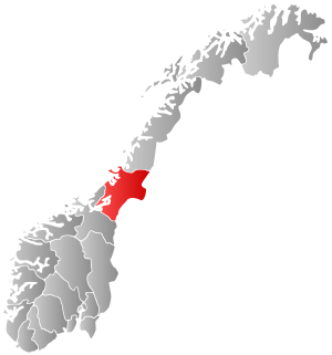
Innherred or Innherad is a traditional district in Trøndelag county in the central part of Norway. It consists of the areas around the inner part of the Trondheimsfjord in the central-east part of the county. The district includes the municipalities of Levanger, Frosta, Steinkjer, Verdal, Inderøy, and Verran. Sometimes, the municipalities of Snåsa and Namdalseid are also included in the Innherred district. The area encompasses about 7,913 square kilometres (3,055 sq mi) and about 68,062 residents (2004). There are several larger towns/cities in Innherred including Steinkjer, Levanger, and Verdalsøra.

Verdalsøra is a town in the municipality of Verdal in Trøndelag county, Norway. The town is the administrative center of the municipality. It is located along the Trondheimsfjord at the mouth of the river Verdalselva. The village of Vinne lies 4 kilometres (2.5 mi) to the southeast, Trones lies about 5 kilometres (3.1 mi) to the north, the villages of Forbregd/Lein lie about 4 kilometres (2.5 mi) to the northeast, and the village of Stiklestad lies about 3 kilometres (1.9 mi) to the east. In 1998, the municipal council of Verdal voted to grant the urban area of Verdalsøra town status under the laws of Norway.
Malm (help·info) is the administrative centre of the municipality of Verran in Trøndelag county, Norway. The village of Malm is located along the Breistadsundet strait which flows into the Trondheimsfjorden. The village of Bartnes lies across the strait from Malm. The village lies about a 32 kilometres (20 mi) drive northwest of the town of Steinkjer, about 12 kilometres (7.5 mi) northwest of the village of Follafoss, and about 20 kilometres (12 mi) south of the village of Namdalseid. The Norwegian County Road 720 runs through the village.
Mære is a village in the municipality of Steinkjer in Trøndelag county, Norway. It is located along European route E6 and the Nordlandsbanen railway line, about 10 kilometres (6.2 mi) south of the town of Steinkjer. The village of Sparbu lies about 2.5 kilometres (1.6 mi) south of Mære. Mære Church is located in this village as well.
Velle is a village in the municipality of Steinkjer in Trøndelag county, Norway. The village sits at the end of one of the innermost parts of the Trondheimsfjord, west of the village of Følling and northeast of the villages of Beitstad and Bartnes. The village sits along Norwegian County Road 17 about 20 kilometres (12 mi) northwest of the town of Steinkjer.

Vuku is a village in the municipality of Verdal in Trøndelag county, Norway. It is located at the confluence of the rivers Helgåa and Inna where they become the Verdalselva river. The village is about 40 kilometres (25 mi) west of the village of Vera and about 15 kilometres (9.3 mi) east of the town of Verdalsøra. Vuku is also a parish covering the central part of Verdal municipality, with Vuku Church located in this village.
Finnvollvatnet is a lake in the municipality of Namdalseid in Trøndelag county, Norway. The 2.97-square-kilometre (1.15 sq mi) lake lies in the western part of the municipality, southwest of the village of Sverkmoen, and only about 3 kilometres (1.9 mi) from the border with the neighboring municipality of Osen. The lake flows out into the Sverka river which eventually ends up in the Namsenfjorden.
Gilten is a lake in the municipality of Steinkjer in Trøndelag county, Norway. The 31.62-square-kilometre (12.21 sq mi) lake lies in the northern part of Steinkjer, about 8 kilometres (5.0 mi) northeast of the village of Kvam, about 1.5 kilometres (0.93 mi) north of the village of Følling, and about 14 kilometres (8.7 mi) east of the village of Namdalseid. The lake is only accessible by road from Namdalseid, even though most of the 31.62-square-kilometre (12.21 sq mi) lake lies in Steinkjer. The lake Bangsjøan lies to the northeast and the lake Snåsavatnet lies to the south.
Otterøy is a former municipality in the old Nord-Trøndelag county, Norway. The 272-square-kilometre (105 sq mi) municipality existed from 1913 until its dissolution in 1964. It was located in the what is now the municipalities of Namsos and Namdalseid in Trøndelag county. The former municipality included most of the island of Otterøya, the island of Hoddøya, the southwestern part of the island of Elvalandet, and some of the mainland southwest of Otterøya and Hoddøya. The area contains good farmland and also good salmon fishing. The main church for the area is Otterøy Church.
Skage or Hunn is a village in the municipality of Overhalla in Trøndelag county, Norway. It is located on the northern shore of the river Namsen, about 10 kilometres (6.2 mi) west of the municipal center, Ranemsletta, and about 15 kilometres (9.3 mi) east of the town of Namsos.

Ekne is a village in the municipality of Levanger in Trøndelag county, Norway. It is located 8 kilometres (5.0 mi) west of the village of Skogn and about 15 kilometres (9.3 mi) southwest of the town of Levanger. The lakes Sønningen and Byavatnet lie south of the village. Ekne Church is located in this village. The World War II-era Falstad concentration camp was also located here.

Sparbu is a village in the municipality of Steinkjer in Trøndelag county, Norway. The village is located about 12 kilometres (7.5 mi) south of the town of Steinkjer. The European route E6 highway runs through the village as does the Nordlandsbanen railway line which stops at the Sparbu Station. The village of Mære lies about 2 kilometres (1.2 mi) to the north, the village of Røra lies about 8 kilometres (5.0 mi) to the south, and the lake Leksdalsvatnet lies about 8 kilometres (5.0 mi) to the east.
Spillum is a village in the municipality of Namsos in Trøndelag county, Norway. The village is located along the south side of the Namsen river about 5 kilometres (3.1 mi) directly south of the centre of the town of Namsos and about 4 kilometres (2.5 mi) north of the village of Klinga. The Norwegian Sawmill Museum is located in the village of Spillum.
Lysthaugen is a village in the municipality of Verdal in Trøndelag county, Norway. It is located on the southern side of the river Verdalselva, about 10 kilometres (6.2 mi) east of the town of Verdalsøra and about 7 kilometres (4.3 mi) southwest of the village of Vuku. The mountain Skitholvola lies about 8 kilometres (5.0 mi) south of the village.
Statland is a village in the northern part of the municipality of Namdalseid in Trøndelag county, Norway. The village lies along the Namsenfjorden, about 10 kilometres (6.2 mi) north of the village of Tøttdalen. The village has a school and Statland Church. The island of Otterøya lies across the fjord from Statland.
The Namsenfjorden or Namsfjorden is a fjord in Trøndelag county, Norway. The 35-kilometre (22 mi) long fjord flows along the border between the municipalities of Namsos, Namdalseid, and Flatanger. It runs southeast from the Folda firth, between the mainland in the south and the island of Otterøya in the north, past the island of Hoddøya, to the Namsen river estuary in the town of Namsos. The banks of the fjord are mostly wooded and not very high. Near the town of Namsos, the Løgnin fjord arm branches to the south all the way to the village of Sjøåsen in Namdalseid. Other villages along the fjord include Statland, Tøttdalen, Skomsvoll, Bangsund, and Spillum.
Beitstad is a former municipality in what was Nord-Trøndelag county, Norway. The 201-square-kilometre (78 sq mi) municipality existed from 1838 until its dissolution in 1964. The municipality encompassed what is now the northeastern part of the municipality of Steinkjer in Trøndelag county. Beitstad was originally quite large, but by 1964, it included the areas east of the Beitstadsundet and Hjellbotn bay and north of the inner-most parts of the Trondheimsfjorden. The administrative centre was the village of Beitstad where Beitstad Church is located.


