
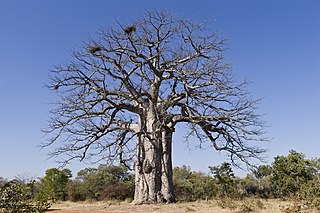
The Namib is a coastal desert in Southern Africa. According to the broadest definition, the Namib stretches for more than 2,000 kilometres (1,200 mi) along the Atlantic coasts of Angola, Namibia, and northwest South Africa, extending southward from the Carunjamba River in Angola, through Namibia and to the Olifants River in Western Cape, South Africa. The Namib's northernmost portion, which extends 450 kilometres (280 mi) from the Angola-Namibia border, is known as Moçâmedes Desert, while its southern portion approaches the neighboring Kalahari Desert. From the Atlantic coast eastward, the Namib gradually ascends in elevation, reaching up to 200 kilometres (120 mi) inland to the foot of the Great Escarpment. Annual precipitation ranges from 2 millimetres (0.079 in) in the aridest regions to 200 millimetres (7.9 in) at the escarpment, making the Namib the only true desert in southern Africa. Having endured arid or semi-arid conditions for roughly 55–80 million years, the Namib may be the oldest desert in the world and contains some of the world's driest regions, with only western South America's Atacama Desert to challenge it for age and aridity benchmarks.

Moçâmedes is a city in southwestern Angola, capital of Namibe Province. The city's current population is 255,000. Founded in 1840 by the Portuguese colonial administration, the city was named Namibe between 1985 and 2016. Moçâmedes has a cool dry climate and desert vegetation, because it is near the Namib Desert.

Namibe Province is a province of Angola. Under Portuguese rule it was the Moçâmedes District. It has an area of 57,091 km2 and had a 2014 census population of 495,326. The port and city of Moçâmedes is the capital of the province with a population of 250,000 in 2014. Iona National Park lies within the province.

A transboundary protected area (TBPA) is an ecological protected area that spans boundaries of more than one country or sub-national entity. Such areas are also known as transfrontier conservation areas (TFCAs) or peace parks.

The Skeleton Coast is the northern part of the Atlantic coast of Namibia. Immediately south of Angola, it stretches from the Kunene River to the Swakop River, although the name is sometimes used to describe the entire Namib Desert coast. The indigenous San people, of the Namibian interior called the region "The Land God Made in Anger", while Portuguese sailors once referred to it as "The Gates of Hell".

The Kaokoveld Desert is a coastal desert of northern Namibia and southern Angola.
Iona National Park is the largest and oldest national park in Angola. It is situated in the Southwestern corner of the country, in Namibe Province. It is roughly bound by the Atlantic Ocean to the West, an escarpment to the East that marks the beginning of the interior plateau, the Curoca River to the North, and the Cunene River to the South. It is about 200 kilometres (120 mi) south of the city of Namibe and covers 5,850 square miles (15,200 km2) sq. miles.

Sioma Ngwezi National Park is a 5,000-square-kilometre park in the south west corner of Zambia. It is undeveloped and rarely visited, lacking roads and being off the usual tourist tracks, but this may change in the future.

Tômbua, formerly known as Porto Alexandre, is a city and municipality in Angola, in Namibe Province. The municipality has a population of 55,494 and the city has a population of 46,573 in 2014. It is located on the shore of Porto Alexandre, an important harbor on the South Atlantic Ocean for oil production and fishing.

The tourism industry in Angola is based on the country's natural environment, including its rivers, waterfalls and coastline. Angola's tourism industry is relatively new, as much of the country was ravaged during the post-colonial civil war which ended in 2002.
Angolan miombo woodlands cover most of central Angola and extend into the Democratic Republic of Congo. They are part of the larger miombo ecosystem that covers much of eastern and southern Africa.
Skeleton Coast National Park is a national park located in northwest Namibia, and has the most inaccessible shores, dotted with shipwrecks. The park was established in 1971 and has a size of 16,845 km2 (6,504 sq mi). The park is divided into a northern and southern section, the southern section is open to those with 4-wheel drive vehicles, they are allowed to go up (north) as far as the Ugab River Gate. The northern section can only be reached by a fly-in safari, and the area is off-limits to all vehicles.

The Iona–Skeleton Coast Transfrontier Conservation Area is a transfrontier conservation area. It encompasses Iona National Park and Namibe Partial Reserve in Angola and Skeleton Coast National Park in Namibia, making it one of the largest in the world. The two countries share a common boundary along the Cunene River, which is where Iona and Skeleton Coast also meet. The Namibe Partial Reserve is north of Iona and shares a border along the Curoca River.
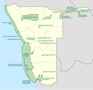
The protected areas of Namibia include its national parks and reserves. With the 2010 declaration of Dorob National Park, Namibia became the first and only country to have its entire coastline protected through a national parks network. Protected areas are subdivided into game reserves and/or nature reserves, such as special protected area, wilderness areas, natural areas, and development areas. There are also recreation reserves. Facilities in the national parks are operated by Namibia Wildlife Resorts. Over 19% of Namibia is protected, an area of some 130,000 square kilometres. However, the Ministry of Environment & Tourism auctions limited hunting rights within its protected areas. The Namibia Nature Foundation, an NGO, was established in 1987 to raise and administer funds for the conservation of wildlife and protected area management. Communal Wildlife Conservancies in Namibia help promote sustainable natural resource management by giving local communities rights to wildlife management and tourism.
The Curoca is an intermittent river in Namibe Province, southern Angola which has residual lagoons in dry seasons. It is one of only two rivers in Iona National Park, which also includes moving sand dunes of the Namib Desert. The Curoca forms part of the northern border of the park and also runs through the Lagoa dos Arcos and the Regional Natural Park of Namibe. Its mouth is at the Atlantic Ocean, north of the community of Tômbwa. The lagoons support plants including bamboo and thorn trees and animals such as springbok and oryx. Lagoa dos Arcos oasis is noted as a tourist destination. The seasonal flooding of the river supports the limited agriculture and grazing conducted in the area.
The Peace Park Foundation, founded in 1997 by Dr Anton Rupert, President Nelson Mandela and Prince Bernhard of the Netherlands, is an organisation that aims to re-establish, renew and conserve large ecosystems in Africa, transcending man-made boundaries by creating regionally integrated and sustainably managed networks of Transfrontier Conservation Areas (TFCAs). Peace Parks Foundation has been involved in the establishment and development of ten of the 18 TFCAs found throughout southern Africa, all of which are in various stages of development. The establishment of each TFCA, or peace park, is complex and far-reaching, and involves several phases of activity, which can take many years to achieve.
Baía de Namibe or Little Fish Bay is a bay in Angola. It is located in the Namibe Province.
Crassothonna agaatbergensis is a species of the genus Crassothonna in the family Asteraceae, and is found only in the northern part of the Skeleton Coast in the Kaokoveld Centre of Endemism, northwestern Namibia.

