Lüderitz is a town in the ǁKaras Region of southern Namibia. It lies on one of the least hospitable coasts in Africa. It is a port developed around Robert Harbour and Shark Island.
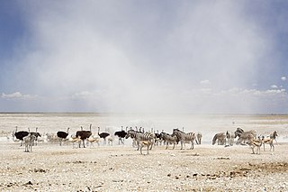
Etosha National Park is a national park in northwestern Namibia and one of the largest national parks in Africa. It was proclaimed a game reserve in March 1907 in Ordinance 88 by the Governor of German South West Africa, Friedrich von Lindequist. It was designated as Wildschutzgebiet in 1958, and was awarded the status of national park in 1967, by an act of parliament of the Republic of South Africa. It spans an area of 22,270 km2 (8,600 sq mi) and was named after the large Etosha pan which is almost entirely within the park. With an area of 4,760 km2 (1,840 sq mi), the Etosha pan covers 23% of the total area of the national park. The area is home to hundreds of species of mammals, birds and reptiles, including several threatened and endangered species such as the black rhinoceros. Sixty-one black rhinoceros were killed during poaching in Namibia during 2022, 46 of which were killed in Etosha.

The Popular Democratic Movement (PDM) is an amalgamation of political parties in Namibia, registered as one singular party for representation purposes. In coalition with the United Democratic Front, it formed the official opposition in Parliament until the parliamentary elections in 2009. The party currently holds 16 seats in the Namibian National Assembly and one seat in the Namibian National Council and is the official opposition. McHenry Venaani is president of the PDM.
Okahandja is a city of 45,159 inhabitants in Otjozondjupa Region, central Namibia, and the district capital of the Okahandja electoral constituency. It is known as the Garden Town of Namibia. It is located 70 km north of Windhoek on the B1 road. It was founded around 1800, by two local groups, the Herero and the Nama.

Okaukuejo is the administrative center for the Etosha National Park in Namibia. It is located approximately 650 km from the capital Windhoek. An average annual rainfall of around 350 millimetres (14 in) is received, although in the 2010/2011 rainy season 676 millimetres (26.6 in) were measured.
The South West Party was a political party in South West Africa, today Namibia. Initially the party was known as Union Party. The party was founded in Windhoek in September 1924 by F. van der Heever, A.P. Olivier, and Andries de Wet. It took the name SWP in 1926.

Luhonono, until 2013 Schuckmannsburg, is a settlement in the Caprivi Strip in northeastern Namibia with a population of about 800. It belongs to the Kabbe North electoral constituency of the Zambezi Region. During the time of German colonialism, it was the capital of the Caprivi Strip.
Otjimbingwe is a settlement in the Erongo Region of central Namibia. Otjimbingwe has approximately 8,000 inhabitants and belongs to the Karibib electoral constituency.

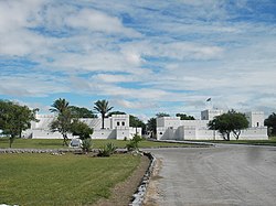
Heroes' Acre is an official war memorial of the Republic of Namibia. Built into the uninhabited hills 10 kilometres (6 mi) south of the city centre of Windhoek, Heroes' Acre opened on 26 August 2002. It was created to "foster a spirit of patriotism and nationalism, and to pass [this] to the future generations of Namibia".
Karl Otto Ludwig Klaus Dierks was a German-born Namibian deputy government minister, a transport planner and civil engineer in Namibia.

The Red Line, also referred to as the veterinary cordon fence, is a pest-exclusion fence separating northern Namibia from the central and southern regions. It encases several northern regions: Oshana Region, Kavango East Region, Omusati Region, Zambezi Region, Omaheke Region, Kunene Region, and parts of the Khomas and Oshikoto Regions. Most of these farms are fenced in and are accessible by constructed farm roads. South of the fence today are commercial farms where the farmers, many of whom are white, own the land. North of the line, on the other hand, all farm land is communal and operated mostly by black farmers. Livestock is not constrained by fences and often ventures onto roads. The red line is a highly guarded line which has roadblocks to check every vehicle which passes. The red line is the reason for Namibia's unique status to export meat across the European Union.

ǁKhauxaǃnas is an uninhabited village with a ruined fortress in south-eastern Namibia, east of the Great Karas Mountains. It is the oldest systematically designed and built structure in Namibia, pre-dating all buildings erected by Europeans. Built at the end of the 18th century, most likely between 1796 and 1798 by Klaas Afrikaner and his two sons Jager and Titus, ǁKhauxaǃnas served as a hidden retreat and a fortress to fend off possible pursuits by Cape authorities. The Orlam Afrikaner tribe left the place in the 1820s but it continued to be inhabited by the Veldschoendragers (ǁHawoben) tribe until the mid-19th century.

Franz Heinrich Kleinschmidt (1812–1864) was a German missionary and linguist who worked in southern Africa, now in the region of Namibia. He founded the missionary station and town of Rehoboth and together with Carl Hugo Hahn set up the first Rhenish mission station to the Herero people in Gross Barmen. Kleinschmidt is known for his scientific work on the Nama language.
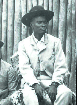
Nehale lya Mpingana was Omukwaniilwa of Ondonga, a subtribe of the Owambo, in German South West Africa. Their tribal area is situated around Namutoni on the eastern edge of Etosha pan in today's northern Namibia. He reigned over the eastern part of the Ondonga area from 1884 until his death; Kambonde II kaMpingana was chief of the western part.

Epukiro is a cluster of small settlements in the remote eastern part of the Omaheke Region of Namibia, situated about 120 kilometres (75 mi) northeast of the regional capital Gobabis. The centre of the populated area is the Catholic mission station. Epukiro had about 3,200 inhabitants in 1997, predominantly ethnic Tswana.

Aminuis is a cluster of small settlements in the remote eastern part of the Omaheke Region of Namibia, located about 500 km east of Windhoek. It is the district capital of the Aminuis electoral constituency.
Namutoni Airport is an airfield serving Namutoni and the Etosha National Park in Namibia. Namutoni is an entrance gate located to the east of the park.
Neudamm is a farm and settlement in the Khomas Region of central Namibia, situated c. 30 kilometres (19 mi) east of Windhoek on the B6 to Gobabis, close to Windhoek's international airport. The entire area is today a campus of the University of Namibia for agricultural education and experimental farming.
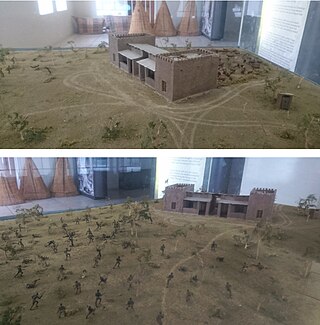
The Battle of Namutoni fought between the militaries of the Ondonga kingdoms and German South West Africa on 28 January 1904 was part of an uprising against German Colonial expansion catalysed by the Herero Uprising to the south that started a few weeks earlier. It was fought at the site of Fort Namutoni in northern Namibia.
The C38 is a secondary route in central Namibia. It is 335 kilometres (208 mi) long, leading from Otjiwarongo via Outjo to Oshivelo. It leads through the Etosha National Park; Drivers need a permit for this section.