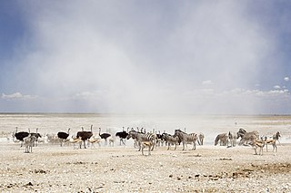
Etosha National Park is a national park in northwestern Namibia and one of the largest national parks in Africa. It was proclaimed a game reserve in March 1907 in Ordinance 88 by the Governor of German South West Africa, Friedrich von Lindequist. It was designated as Wildschutzgebiet in 1958, and was awarded the status of national park in 1967, by an act of parliament of the Republic of South Africa. It spans an area of 22,270 km2 (8,600 sq mi) and was named after the large Etosha pan which is almost entirely within the park. With an area of 4,760 km2 (1,840 sq mi), the Etosha pan covers 23% of the total area of the national park. The area is home to hundreds of species of mammals, birds and reptiles, including several threatened and endangered species such as the black rhinoceros. Sixty-one black rhinoceros were killed during poaching in Namibia during 2022, 46 of which were killed in Etosha.
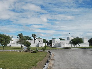
Namutoni is a restcamp on the eastern edge of the Etosha pan in the Oshikoto Region in northern Namibia. The adjoining Von Lindequist Gate about 10km east is one of the entrance gates to the Etosha National Park.

The Grootfontein Air Force Base is an air base of the Namibian Air Force in Grootfontein, a town in the Otjozondjupa Region of Namibia. The air base is about 4 km (2 mi) south of the center of Grootfontein.
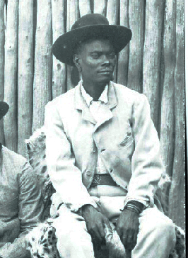
Nehale lya Mpingana was Omukwaniilwa of Ondonga, a subtribe of the Owambo, in German South West Africa. Their tribal area is situated around Namutoni on the eastern edge of Etosha pan in today's northern Namibia. He reigned over the eastern part of the Ondonga area from 1884 until his death; Kambonde II kaMpingana was chief of the western part.
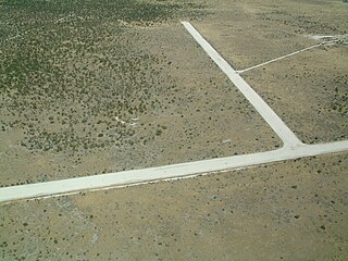
Halali Airport is an airport serving the resort of Halali, in the Oshikoto Region of Namibia. The resort is near some of the waterholes of the Etosha National Park, and has elevated viewing platforms for observing native wildlife like elephants, rhinoceros, and leopards.
Kamanjab Airport is an airport serving the village of Kamanjab in the Kunene Region of Namibia. The runways are 11 kilometres (6.8 mi) north of the settlement.
Karasburg Airport is an airport serving the town of Karasburg in ǁKaras Region, Namibia. The runways are 1 kilometre (0.62 mi) southwest of the town.
Mariental Airport is an airport serving the town of Mariental, in the Hardap Region of Namibia.

Mokuti Lodge Airport is an airport serving Mokuti Lodge resort and the Etosha National Park in Namibia.
Mount Etjo Airport is an airport serving Mount Etjo Safari Lodge and the Okonjati Game Reserve in Namibia.
Okaukuejo Airport is an airport in the Oshana Region of Namibia, serving the Etosha National Park and its administrative center, Okaukuejo. The runways are 3 kilometres (1.9 mi) north of the village.
Omega Airport is a former military airport serving the village of Omega in the Kavango East Region of Namibia.
Opuwo Airport is an airport serving Opuwo, Namibia.
Oshakati Airport was an airport serving Oshakati in the Oshana Region of Namibia.
Otjiwarongo Airport is an airport serving Otjiwarongo, in the Otjozondjupa Region of Namibia.
Outjo Airport is an airport serving Outjo, in the Kunene Region of Namibia.

913 Battalion was part of 91 South West African Brigade.
Ruacana Airport is an airport serving Ruacana and the Ruacana hydroelectric power station in the Omusati Region of Namibia.
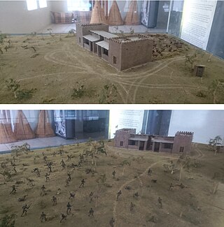
The Battle of Namutoni fought between the militaries of the Ondonga kingdoms and German South West Africa on 28 January 1904 was part of an uprising against German Colonial expansion catalysed by the Herero Uprising to the south that started a few weeks earlier. It was fought at the site of Fort Namutoni in northern Namibia.
The C38 is a secondary route in central Namibia. It is 335 kilometres (208 mi) long, leading from Otjiwarongo via Outjo to Oshivelo. It leads through the Etosha National Park; Drivers need a permit for this section.


