Air Namibia (Pty) Limited, which traded as Air Namibia, was the national airline of Namibia, headquartered in the country's capital, Windhoek. It operated scheduled domestic, regional, and international passenger and cargo services, having its international hub in Windhoek Hosea Kutako International Airport and a domestic hub at the smaller Windhoek Eros Airport. As of December 2013, the carrier was wholly owned by the Namibian government. Air Namibia was a member of both the International Air Transport Association and the African Airlines Association.

Erongo is one of the 14 regions of Namibia. The capital is Swakopmund. It is named after Mount Erongo, a well-known landmark in Namibia and in this area. Erongo contains the municipalities of Walvis Bay, Swakopmund, Henties Bay and Omaruru, as well as the towns Arandis, Karibib and Usakos. All the main centres within this region are connected by paved roads.

Swakopmund is a city on the coast of western Namibia, 352 km (219 mi) west of the Namibian capital Windhoek via the B2 main road. It is the capital of the Erongo administrative district. It has 75,921 inhabitants.

Otjiwarongo is a city of 49,000 inhabitants in the Otjozondjupa Region of Namibia. It is the district capital of the Otjiwarongo electoral constituency and also the capital of Otjozondjupa.

Eros Airport or Windhoek Eros Airport is an airport serving Windhoek, the capital and largest city of Namibia. It is located in the Khomas Region, about 5 km (3 mi) south of Windhoek's central business district, and has been a secondary hub for Air Namibia.

Maun Airport is an international airport serving the town of Maun in the North-West District of Botswana. It is on the north side of the town and is accessible by shuttle bus or taxi.

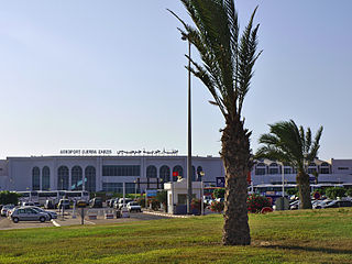
Djerba–Zarzis International Airport is an international airport serving the island of Djerba in Tunisia. The airport was enlarged and named Djerba Zarzis International Airport in 1970. However, the airport dates to 1950. Today, it is an important destination for seasonal leisure flights.

Wilderness Air, formerly known as Sefofane Air Charter, is an air charter company headquartered in Botswana, Africa.

Tourism in Namibia is a major industry, contributing N$7.2 billion to the country's gross domestic product. Annually, over one million travelers visit Namibia, with roughly one in three coming from South Africa, then Germany and finally the United Kingdom, Italy and France. The country is among the prime destinations in Africa and is known for ecotourism which features Namibia's extensive wildlife.

The Namibia Cricket Board, known commercially as Cricket Namibia, is the official governing body of the sport of cricket in Namibia. Its current headquarters is in Windhoek, which is the capital and largest city of Namibia. Cricket Namibia is Namibia's representative at the International Cricket Council and has been an Associate Member of that body since 1992. It is also a Member of the African Cricket Association.

Windhoek railway station is a railway station serving the city of Windhoek, the capital of Namibia. It is an important station in the Namibian rail network, and it is run by TransNamib.
C28 is an secondary road in central Namibia. It is 319 kilometres (198 mi) long and connects Windhoek to Swakopmund via the Bosua Pass. The C28 rises up to an altitude of 1,924 metres (6,312 ft) above sea level and crosses the Namib Desert and the Namib-Naukluft National Park.

Swakopmund railway station is a railway station serving the town of Swakopmund in Namibia. It is part of the TransNamib railway network. Its IATA code is ZSZ.

The Grootfontein Air Force Base is an air base of the Namibian Air Force in Grootfontein, a town in the Otjozondjupa Region of Namibia. The air base is about 4 km (2 mi) south of the center of Grootfontein.

Swakopmund constituency is a constituency in the Erongo Region of Namibia. The constituency had a population of 44,725 in 2011, up from 26,310 in 2001. It covers 196.3 square kilometres (75.8 sq mi) of land. Its district capital is the city of Swakopmund. As of 2020 the constituency had 35,668 registered voters.

Westair Aviation Limited is a Namibian aviation service provider and airline offering scheduled passenger services under the FlyNamibia brand as well as cargo and Aircraft, Crew, Maintenance and Insurance (ACMI) services based at Eros Airport in Windhoek.

The A1 is a national highway in Namibia. The 76 kilometres (47 mi) stretch of road between Windhoek and Okahandja is the only A-rated road in Namibia. Consisting of freeway for its entire length, it came into existence in 2017 when freeway sections of the B1 were redesignated A1 in accordance with new standards of the Roads Authority Namibia. The entirety of the A1 forms part of the Trans-Kalahari Corridor and, together with the B1, also forms part of the Tripoli-Cape Town Highway.


