
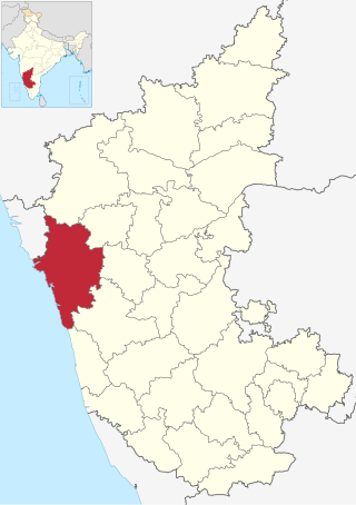
Uttara Kannada is a district in the Indian state of Karnataka. It is a major coastal district of Karnataka, and is the third largest district in Karnataka. It is bordered by the state of Goa and Belagavi districts to the north, Dharwad District and Haveri District to the east, Shivamogga District, and Udupi District to the south, and the Laccadive Sea to the west.

Kanara or Canara, also known as Karavali is the historically significant stretch of land situated by the southwestern coast of India, alongside the Arabian Sea in the present-day Indian state of Karnataka. The subregion comprises three civil districts, namely: Uttara Kannada, Udupi, and Dakshina Kannada. Kassergode was included prior to the States Reorganisation Act.
Torke is a small village in Kumta taluk of Uttara Kannada district, Karnataka, India. This village is about a few square kilometres in extent. Torke traditionally is the amalgamation of Hoskatt, Naranapur, Toregazani, Torke, Devarabhavi, Hallergudi, Devana and Gonehalli. It has a Gram Panchayat.

Karwar is a seaside city, taluka, and administrative headquarters of Uttara Kannada district lying at the mouth of the Kali river on the Kanara coast of Karnataka state, India.
Idagunji is a small village in Honnavar Taluk, in the Uttara Kannada district of Karnataka state, India.
Dandeli is a taluk in Uttara Kannada district of Karnataka, India, in the Malenadu region.

Sirsi is a city and a taluk headquarter in Uttara Kannada district of Karnataka state in India. It was also known as Kalyana Pattana during the Sonda Dynasty. It is a tourist destination with evergreen forest and waterfalls and is also a commercial centre. The main businesses around the city are mostly subsistence and agriculture-based. Areca nut or betel nut, locally known as Adike, is the primary crop grown in the nearby villages, making it one of the major trading centres for areca nut. The region is also known for spices such as cardamom, pepper, betel leaves, and vanilla. The major food crop is paddy. This city is about 72.2 km away from the city of Sagara and 144.4 km away from Shimoga.
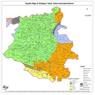
Siddapur Taluk is the destination of world famous Jog Falls. It is a part of Uttara Kannada district, Karnataka, India and is located in the midst of forest areas of Western Ghats and it is also a part of Malenadu. The taluk is full of greenery, hills and arecanut gardens developed in the valleys’. The taluk headquarters is Siddapur. Sirsi is the nearest city,

Karnataka, the sixth largest state in India, has been ranked as the third most popular state in the country for tourism in 2014. It is home to 507 of the 3600 centrally protected monuments in India, second only to Uttar Pradesh. The State Directorate of Archaeology and Museums protects an additional 752 monuments and another 25,000 monuments are yet to receive protection.
Ulavi is a village in the Uttara Kannada district in the Indian state of Karnataka. Ulavi is a village about 75 kilometres (47 mi) from Karwar in Karnataka state, India.
Karnataka's coastline called Karavali stretches 300 km between Mangalore in Dakshina Kannada district and Karwar in Uttara Kannada district. The coastline of Karnataka has been along the eastern shore of Arabian Sea. Karnataka has one major and ten minor ports in this coastal belt. Kali, Belekeri, Gangavali, Aghanashini Sharavathi, Sharabi, Kollur, Gangolli, Sitanadi, Gurpur and Netravati are the important rivers in this belt which empty into the Arabian sea. Sea erosion, migration of river mouths, siltation of ports and harbours are some of the problems common to this belt.
Joida is a town located in the Uttara Kannada district in the Indian state of Karnataka. The town is the headquarters of the eponymous taluk. Earlier it was known as Supa taluka but as Supa village got submerged due to dam built across river Kali, Joida taluka came into existence. Joida town has a Post office, branch of nationalised banks and a Police station.

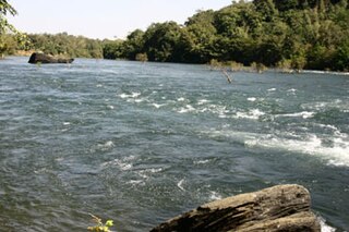
The Kali River or Kaali Nadi is a river flowing through Uttara Kannada district of Karnataka state in India. The river rises near Kushavali, a small village in Uttar Kannada district. The river is the lifeline to some 400,000 people in the Uttara Kannada district and supports the livelihoods of tens of thousands of people including fishermen on the coast of Karwar. There are many dams built across this river for the generation of electricity. One of the important dams build across Kali river is the Supa Dam at Ganeshgudi. The river runs 184 kilometers before joining Arabian Sea.
Majali is a hamlet in the Uttar Kannada district of Karnataka, India. It is situated in a coastal region called Kanara at the Goa-Karnataka border. The language spoken there are Konkani and Kannada.
Ajjibal is a village in the southern state of Karnataka, India. It is located in the Sirsi taluk of Uttara Kannada district in Karnataka.

Sadashivgad is a village located in Karwar, Uttara Kannada district, in the state of Karnataka in India. Significant and picturesque, it is now a popular tourist destination located by the Kali river bridge, which has been built at the confluence of the river and the Arabian Sea.
Asnoti is a village in Karwar Taluka, Uttara Kannada district, Karnataka, India. It is close to the historic fort of Sadashivgad located on Kali river. Konkani is spoken as a local language.
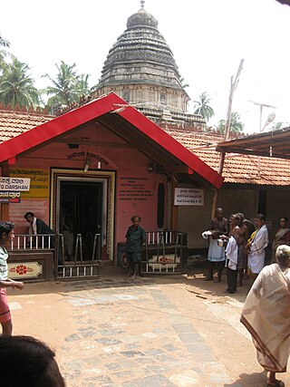
The Mahabaleshwar Temple, Gokarna is a 4th-century CE Hindu temple located in Gokarna, Uttara Kannada district, Karnataka state, India which is built in the classical Dravidian architectural style. It is a site of religious pilgrimage. The temple faces the Gokarna beach on the Arabian Sea. The temple deifies the Pranalinga also called Atmalinga or Shiva Linga In legend, it is said that the deity of the temple will bestow immense blessings to devotees, even to those who only glimpse it. Currently the administrative charge of the temple is with an Overseeing Committee under the Chairmanship of Justice BN Srikrishna, a Retired Justice of the Hon'ble Supreme Court of India. It is one of the 275 paadal petra sthalams expounded in the Tevaram, a sacred Tamil Shaivite text written during the 6th and 7th centuries by 63 saints called Nayanars.
Mudgeri is a village in Karwar Taluka, Uttara Kannada district, Karnataka, India. It is close to the historic fort of Sadashivgad located on Kali river. Konkani is spoken as a local language.

Apsarkonda is an emerging tourist village near Honnavar, in the district of Uttara Kannada, Karnataka, India. It is situated 8 km from the Honnavar bus stand.


