Aral Nani is known for its landscape, geography, ecosystems, wildlife and culture as well as being known as a religious place.
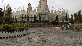
About 4 kilometres (2.5mi) away is a temple on the hill known as Dhinodhar Hills. Dinodhar is a pilgrimage spot and now many tourist comes here to enjoy taste of fresh air. It's actually an inactive volcano with 386 meters elevation. From Dinodhar hill there are views of Great Rann of Kutch and Chari-Dhand Wetland Conservation Reserve. Dating 325 BCE, Alexander the Great was aware of this part of Gujarat.
The village of Aral Nani also includes a 3-star hotel "Infinity Rann Of Kutch" located in Khatau Wadi region of this village. Aral Nani is located in a small band of land, just inland from the coast, where four distinct ecosystems (desert, coastal, grassland and upland) exists within a span of 100km. Huge wetlands are created in a good monsoon year providing habitats for resident and migratory birds, including the Flamingo City, which is the largest and the only known breeding ground of greater and lesser flamingos in India. The area together with the Banni grasslands and other smaller wetlands like Chari-Dhand Wetland Conservation Reserve is one of the best areas to see rare bird species like the grey hypocolius, Eurasian eagle-owl, common crane, Dalmatian pelican, houbara bustard, curlew sandpiper, sociable plover, cream-coloured courser and Indian skimmer.
Nani Aral has a primary school up till 7th standard. For higher education students need to go to Nakhatrana or Bhuj.
Popular For
This village is known for a tropical fruit i.e., the Pilu, also referred as Pilu is grown only in this part of the world.[citation needed]
Aral Nani is at 12km by road north of the town of Nakhatrana and 64km by road northwest of Bhuj.
Demographics
In the 2001 census, the village of Aral Nani had 1,215 inhabitants, with 639 males (52.6%) and 576 females (47.4%), for a gender ratio of 901 females per thousand males.[4]
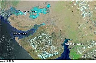
The Great Rann of Kutch is a salt marsh in the Thar Desert in the Kutch District of Gujarat, India. It is about 7500 km2 in area and is reputed to be one of the largest salt deserts in the world. This area has been inhabited by the Kutchi people.
Kutch district, officially spelled Kachchh, is a district of Gujarat state in western India, with its headquarters (capital) at Bhuj. Covering an area of 45,674 km2, it is the largest district of India. The area of Kutch District is larger than the entire area of states like Haryana (44,212 km2) and Kerala (38,863 km2). The population of Kutch is about 2,092,371. It has 10 talukas, 939 villages and 6 municipalities. The Kutch district is home to the Kutchi people who speak the Kutchi language.
The 2001 Gujarat earthquake, also known as the Bhuj earthquake, occurred on 26 January at 08:46 am IST. The epicentre was about 9 km south-southwest of the village of Chobari in Bhachau Taluka of Kutch (Kachchh) District of Gujarat, India.
Nakhatrana is a panchayat village and headquarters for a taluka in the middle of Kutch (kachchh), Gujarat, in India.
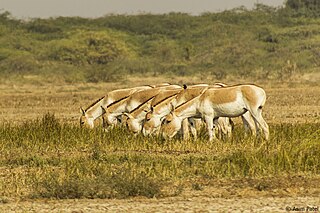
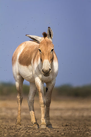
Indian Wild Ass Sanctuary also known as the Wild Ass Wildlife Sanctuary is located in the Little Rann of Kutch in the Gujarat state of India. It is spread over an area of 4954 km².
The Indian wild ass, also called the Indian onager or, in the local Gujarati language, Ghudkhur and Khur, is a subspecies of the onager native to South Asia.
Banni Grasslands Reserve or Banni grasslands form a belt of arid grassland ecosystem on the outer southern edge of the desert of the marshy salt flats of Rann of Kutch in Kutch District, Gujarat State, India. They are known for rich wildlife and biodiversity and are spread across an area of 3,847 square kilometres. They are currently legally protected under the status as a protected or reserve forest in India. Though declared a protected forest more than half a century ago Gujarat state's forest department has recently proposed a special plan to restore and manage this ecosystem in the most efficient way. Wildlife Institute of India (WII) has identified this grassland reserve as one of the last remaining habitats of the cheetah in India and a possible reintroduction site for the species.
The Chari-Dhand wetland conservation reserve is located on the edge of arid Banni grasslands and the marshy salt flats of the Rann of Kutch in Kutch district, Gujarat State in India. It is currently legally protected under the status as a Protected or Reserve Forest in India. Chari means salt affected and Dhand means shallow wetland, Dhand is a Sindhi word for a shallow saucer shaped depression. This is a seasonal desert wetland and only gets swampy during a good monsoon, receiving water from the north flowing rivers as well as from the huge catchment areas of many surrounding big hills. It is spread over an area of 80 km2. It is in Nakhtrana Taluka, 80 km south west to the city of Bhuj, about 7 or 8 km from Fulary village and 30 km from Nakhtrana town. It is home to nearly two lakh birds with migratory and endangered species of birds flocking into the area in thousands during monsoon and winters.
The Rann of Kutch is a large area of salt marshes that span the border between India and Pakistan. It is located mostly in the Kutch district of the Indian state of Gujarat, with a minor portion extending into the Sindh province of Pakistan. It is divided into the Great Rann and Little Rann.
The Kutch Desert Wildlife Sanctuary is situated in the Great Rann of Kutch, Kutch district, Gujarat, India. It was declared a sanctuary in February 1986. It is the largest Wildlife Sanctuary in India regarding its size.
Kutch Bustard Sanctuary or Kachchh Great Indian Bustard Sanctuary, also known as Lala–Parjan Sanctuary, is located near Jakhau village in Taluka Abdasa, Gujarat, India. This sanctuary is one of the two great Indian bustard sanctuaries in Gujarat; the other one is in Jamnagar. It was declared as a sanctuary in July 1992, specifically for the conservation of the great Indian bustard, the heaviest flying bird belonging to the avian family of Otididae. However, the sanctuary presently legally covers a protected area of about 2 square kilometres (0.77 sq mi) of area (202.86 hectares of fenced land only and is the smallest sanctuary in the country. Several suggestions have been made to vastly increase the size of this sanctuary as it is a breeding ground of the endangered great Indian bustard. The reason is that its ecological zone is much larger on account of anthropogenic and cattle population pressure that are considered as a ‘biotic threat’ to this omnivorous species.
Dhinodhar Hills are located near Nani Aral village, in Nakhatrana Taluka, Kutch District, Gujarat, in India. Dhinodhar Hill is a tourist and pilgrimage spot.
Naliya is a town, which is also the taluka headquarters of Abdasa Taluka of Kutch District (kachchh), Gujarat, India. It is located on the western end of Kutch 19 km by road from ancient port of Jakhau.
Tera is a historic village in the Kutch District of the Indian state of Gujarat. It is in Abdasa Taluka, located 13 kilometres (8.1 mi) from the taluka headquarters, Naliya, and 84 kilometres (52 mi) from the district headquarters, Bhuj.
Netra is a panchayat village in Gujarat, India. Administratively it is under Nakhatrana Taluka in Kutch District, Gujarat.
Nakhatrana Taluka is a taluka in Kutch District, Gujarat, India. Its administrative centre is the village of Nakhatrana. The taluka covers 2,135.14 square kilometres (824 sq mi).
Fulay is a small village in Gujarat, India. Administratively it is under Kotay Gram Panchayat, Bhuj Taluka, Kutch District, Gujarat. Much of the village has been abandoned. Fulay is 1.5 km by road east of the village of Kotay, and 30 km by road northeast of the city of Bhuj.
Mothala is a panchayat village in Gujarat, India. Administratively it is under Abdasa Taluka, Kutch District, Gujarat. Mothala is 23 km by road northeast of the village of Kothara, and 33 km by road southwest of the village of Nakhatrana. Mothala is located on the rail line from Bhuj to Naliya; formerly military only, it now carries commercial freight and passengers, and is scheduled to be upgraded from metre to 5 ft 6 in broad gauge.
Dumara is a panchayat village in Gujarat, India. Administratively it is under Abdasa Taluka, Kutch District, Gujarat. The village of Dumara sits on the left (west) bank of the Chok River, an intermittent stream. It is 20 km (12 mi) by road southeast of the village of Kothara along National Highway 8A, and 38 km (24 mi) along the same road northwest of the town of Mandvi.
Vighodi (Vigodi) is a panchayat village in Gujarat, India. Administratively it is under Nakhatrana Taluka, Kutch District, Gujarat. Vighodi lies along Gujarat State Highway 42 between the villages of Rawapur to the northwest and Ratadiya to the east-southeast.
This page is based on this Wikipedia article Text is available under the CC BY-SA 4.0 license; additional terms may apply. Images, videos and audio are available under their respective licenses.