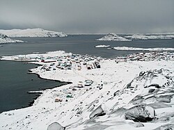
Nanortalik, formerly Nennortalik, is a town in Nanortalik Island, Kujalleq municipality, southern Greenland. With 1,185 inhabitants as of 2020, it is the eleventh-largest town in the country. The name Nanortalik means "Place of Polar Bears" or "Place Where the Polar Bears Go". It is the southernmost town in Greenland with a population of over 1,000.

Alluitsup Paa is a village in the Kujalleq municipality in southern Greenland. Alluitsup Paa had 202 residents in 2020. Presently, the community's religious activities take place in Qaqortoq.

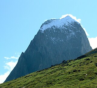
Aappilattoq is a village in the Kujalleq municipality in southern Greenland. The name means "red", after the red mountain rising above the settlement in the Greenlandic language. The settlement had 100 inhabitants in 2020.
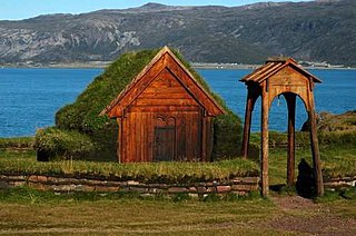
Qassiarsuk is a settlement in the Kujalleq municipality, in southern Greenland. Its population was 39 in 2020.

Eqalugaarsuit is a settlement in the Kujalleq municipality in southern Greenland, located southeast of Qaqortoq and northwest of Alluitsup Paa. Its population was 49 in 2020.

Tasiusaq is a settlement in the Kujalleq municipality in southern Greenland, founded in 1933. It is located at the Tasermiut Fjord, east of Nanortalik. Its population was 53 in 2020. In the Greenlandic language, the name of the settlement means "like a lake", referring to the lake-looking bay it situated on. The inhabitants call it "Tasiisaq", which is the local dialect.
Narsarmijit, also known as Narsaq Kujalleq, formerly Frederiksdal, is a settlement in southern Greenland. It is located in the Kujalleq municipality near Cape Thorvaldsen. Its population was 66 in 2020. There has been a slow but steady pattern of emigration since the late 1950s.

Ammassivik is a settlement in the Kujalleq municipality in southern Greenland. The modern name is the Kalaallisut for "where you catch ammassaat (capelin)". Its population was 74 in 2010 and 32 in 2020.

Saarloq is a settlement in the Kujalleq municipality in southern Greenland. Its population was 21 in 2020. It is located on a small island with the same name off the Labrador Sea coast, at the mouth of the Qaqortoq Fjord, west of Alluitsup Paa and 20 km south of Qaqortoq.

Qassimiut is a settlement in the Kujalleq municipality in southern Greenland. The settlement was founded in 1835 as a trading station. With a population of 20 in 2020, it is the smallest organized, permanent settlement in Greenland.
Greenland is divided into five municipalities – Avannaata, Kujalleq, Qeqertalik, Qeqqata, and Sermersooq – as well as the large Northeast Greenland National Park which is unincorporated. The Thule Air Base is administered by the United States Air Force and operates as an unincorporated enclave surrounded by territory of Avannaata.
Qorlortorsuaq is a village in the Nanortalik district, in the Kujalleq municipality in southern Greenland, located at the site of the largest waterfall in the country; the waterfall also goes by the name of Qorlortorsuaq. In 2020, the town had only 4 inhabitants. The population consists mostly of farmers. Qorlortorsuaq also houses the only trout farm in the country

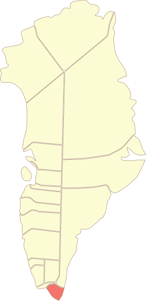
Kujalleq is a municipality on the southern tip of Greenland, operational from 1 January 2009. The administrative center of the municipality is in Qaqortoq. The municipality consists of the former municipalities of southern Greenland, each named after the biggest settlement:
Nanortalik Heliport is a heliport in the eastern part of Nanortalik, a town in the Kujalleq municipality in southern Greenland.
Aappilattoq Heliport is a heliport in Aappilattoq, a village in the Kujalleq municipality in southern Greenland. The heliport is considered a helistop, and is served by Air Greenland as part of a government contract.
Ammassivik Heliport is a heliport in Ammassivik, a village in the Kujalleq municipality in southern Greenland. The heliport is considered a helistop, and is served by Air Greenland as part of government contract.
Narsaq Kujalleq Heliport or Narsarmijit Heliport is a heliport in Narsaq Kujalleq, a village in the Kujalleq municipality in southern Greenland. The heliport is considered a helistop, and is served by Air Greenland as part of a government contract.
Tasiusaq Heliport is a heliport in Tasiusaq, a village in the Kujalleq municipality in southern Greenland. The heliport is considered a helistop, and is served by Air Greenland as part of a government contract.

Narsaq Municipality was a municipality in south Greenland until 31 December 2008. The municipality consisted of Narsaq, and the settlements Qassiarsuk, Igaliku, and Narsarsuaq. Its administrative center was the town of Narsaq. It was incorporated into the new Kujalleq municipality on 1 January 2009, when the municipalities of Narsaq, Nanortalik, and Qaqortoq ceased to exist as administrative entities.
The Ketil is a 2,010 m–high mountain in southern Greenland, in the Kujalleq municipality.